The National Weather Service in Eureka, CA has published a fire weather watch in effect from 3:17 PM Thursday, Aug 8, 2013. The following is the alert (The alert has been modified slightly from all uppercase to lowercase letters, etc.) The agency is warning of thunderstorms with “abundant lightning today and possibly again on Friday.”
An upper low moving towards northwest California will bring a threat of thunderstorms to areas of Trinity, northeast Humboldt, northeast Mendocino, and eastern Del Norte counties this evening through Saturday. The greatest threat are those areas bordering Siskiyou County with a lesser threat over Mendocino county. The activity will start this afternoon and continue into the evening.
Thunderstorms may be accompanied by heavy rain, possible hail, and locally gusty winds. Scattered shower activity will likely occur again on Friday but there is still uncertainty regarding the amount of thunderstorms. Only a few storms will be possible Saturday mainly over the higher terrain bordering Siskiyou County.
There is a Red Flag warning for—
areas of the Upper Smith, inland Portion of the Smith River drainage within the Six Rivers National Forest, lower middle Klamath, inland portion of the Klamath River drainage within the Six Rivers National Forest and the Ukonom district of the Klamath National Forest, Hupa, the Hoopa Indian Reservation and the lower portion of the Trinity River drainage within the Six Rivers National Forest, Trinity, the western portion of the Shasta Trinity National Forest, there is a Red Flag warning from alert in affect from 3:17 PM Thursday, Aug 8, 2013.
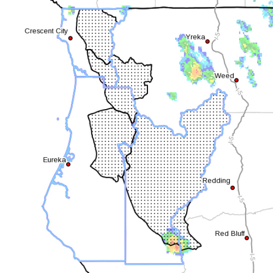
The Red Flag warning now in effect until 11 AM PDT Friday for thunderstorms for fire weather zones 203…204…211…212…277 and 283. The fire weather watch now in effect from Friday morning through Friday evening for thunderstorms for fire weather zones 203…204…211…212…277 and 283.
*Affected area…Fire Weather zones 203…204…211 and 283.
*.Thunderstorm activity is expected this evening and tonight. Possibly lasting into Friday morning. The highest threat will be near the border with Siskiyou County this afternoon. Later tonight into Friday morning there is a chance for more thunderstorms. Additional thunderstorms are possible Friday afternoon.
* outflow winds and hail…Collapsing Thunderstorms may produce gusts over 40 mph. Otherwise winds will remain generally light and terrain driven. Hail up to quarter size will be possible with the strongest storms.
* Impacts: Dry fuels along with the potential for abundant lightning may result in new fire starts.
…A fire weather watch means that critical fire weather conditions are forecast to occur. Listen for later forecasts and possible red flag warnings.
A red flag warning means that critical fire weather conditions are either occurring now or will shortly. A combination of strong winds, low relative humidity and warm temperatures can contribute to extreme fire behavior.
CLICK TO MANAGE