Good news for our parched watersheds: “Significant rainfall” is expected through Saturday in Humboldt, Del Norte and western Trinity counties, according to the National Weather Service.
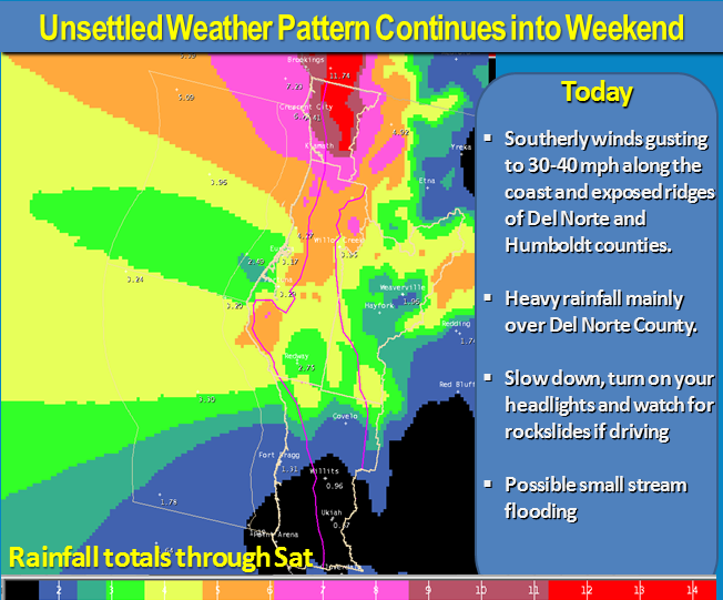
But there’s also a warning in the forecast: The NWS has issued a “Hazardous Weather Outlook” for northwest California due to wind gusts up to 40 miles per hour along the coast and heavy rainfall. The expected impacts are as follows:
- Main stem rivers will have rapid rises and increased flow.
- Main stem rivers are expected to remain below monitor stage, though Smith, Mad and Van Duzen Rivers may get within 4 feet of monitor stage.
- Small streams and tributaries will also have rapid rises and increased flow and during the period Thursday through Saturdaymay occasionally exceed their banks.
- Localized street flooding is possible during periods of moderate rain.
- Rock and mudslides along highways and county roads in mountainous terrain.
And here are the projected rainfall amounts:
- Smith River Basin…………………….10 to 12 inches
- Lower Klamath River Basin……….. 8 to 9 inches
- Redwood Creek…………………………. 8 to 9 inches
- Eel River Basin………………………….. 4 to 5 inches
- South Fork Eel River………………………. 4 to 5 inches
- Mad River Basin…………………………..5 to 6 inches
- Van Duzen River Basin………………. 5 to 6 inches
- Trinity River Basin………………………. 3 to 4 inches
- Upper Russian River Basin…………1 to 2 inches
- Navarro River Basin……………………. 1 to 2 inches
Stay safe out there, folks.
CLICK TO MANAGE