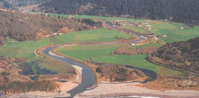
The mouth of Redwood Creek, lined by levees.
Back in 2009, some parts of the county received unwelcome news from the Federal Emergency Management Agency. Land owners in Orick, Blue Lake and the Jacobs Avenue area of Eureka were told that the levees holding back rivers and sloughs from inundating their properties could no longer be certified to do their job in the event of a truly major storm. Therefore, FEMA said, it would soon be altering its flood maps to show that the land behind those levees was at risk of flood. Residents and business owners in those areas would soon be required to buy flood insurance.
The proposed augmentation of the FEMA flood maps – which happened all around the country, as the agency regrouped after the Hurricane Katrina disaster – never quite took effect in Humboldt County. (See Times-Standard and North Coast Journal coverage from that era.) There was a great hue and cry from the affected citizens, county government protested the decision, and somehow the proposal never went forward. FEMA’s proposed change to its Humboldt County flood insurance map has remained just that – “proposed” – for nearly six years, while property owners were left in limbo.
But local government and affected land owners have been working behind the scenes with FEMA all this time, and some of the first fruit of those talks was published in the Federal Register this morning. There, FEMA officially announced that has formally dropped at least some of the changes it proposed back in 2009.
FEMA’s published decision this morning appears to affect only the levees around Orick, which wall the final stretch of Redwood Creek off from the town. However, Hank Seemann, the county’s deputy director of public works and the person who has been heading up the county’s efforts on this project, told the Outpost that he expects the agency to drop both Orick and the affected part of Blue Lake from the changes FEMA proposed in 2009. If so, that means the areas in question – the entirety of downtown Orick and a stretch of Blue Lake that includes its industrial park – will no longer be threatened with mandatory insurance premiums to cover potential floods.
“That would have been a huge socioeconomic impact on a town like Orick, especially,” Seemann said today.
Though FEMA’s notice today appears on its face to reverse the six-year-old proposed map change, that isn’t exactly the case, Seemann said. What the county and FEMA have together been working toward is moving Orick and Blue Lake into a separate bureaucratic category of flood risk known, in the FEMA jargon, as “seclusion.” Flood-risk areas with uncertified levees are eligible for seclusion designation if the levees meet certain standards, and if “significant changes are being made to the flood hazards.” Seemann expects that after withdrawing the 2009 proposed changes for Blue Lake and Orick, FEMA will soon resubmit them as seclusion maps. For landowners, the end results will be the same, as far as flood insurance is concerned. They will no longer have to worry about mandatory enrollment in such a program.
Such is not the case for the other major area proposed to be added to the flood zone in 2009: The Jacobs Avenue industrial/commercial area on the east side of Eureka. Seemann said that this is largely because the levees holding back the Mad River and Redwood Creek (in Blue Lake and Orick, respectively) were constructed by the Army Corps of Engineers, are in public ownership, and are in relatively good repair. The levee holding the waters back from Jacobs Avenue are privately held and were constructed willy-nilly over the years. (The problems with the Jacobs Avenue levee were discussed at length in this memorable Heidi Walters article from 2011.)
Reached at work this morning, Ronald Barlow, president of the Orick Community Services District hailed the news of the official death of the 2009 proposal.
“It’s a good thing that it’s not being mapped as a flood plain,” he said. “Now you can just have the flood insurance if you feel you need it, but it’s not required.” He said that the flood insurance on his own home amounted to $300 per year, but that insurance takes only the home into account – not his barn, fences or livestock. It would cost much more to insure those things, and in a poor community such as Orick every dollar matters.
Up in Blue Lake, City Manager John Berchtold of Blue Lake said that he had not heard of this morning’s notice. He did, however, say that the city has devoted considerable work to the issue since 2009, and that he had already been planning to submit a brief report on the matter to his council at its next meeting. An overview of efforts to date should be posted on the city’s website tomorrow afternoon, he said.
Final matter to note: The impending “seclusion” decision might give some impetus to the longstanding plan to improve Redwood Creek’s long outmoded levees, which may hold the water back relatively well, but are very poorly designed so far as salmonid habitat is concerned. The county will be promising improvements to flood containment infrastructure to qualify for the seclusion program, and those improvements could help habitat restoration along. The county just published an omnibus overview of the Redwood Creek levees and estuary at the end of last year that explicitly links the two things.
DOCUMENTS
CLICK TO MANAGE