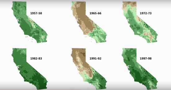
Rainfall during every ‘strong’ El Niño year since 1950, as compared to average rainfall. Green is wetter than average, brown is drier.
The Lost Coast Outpost bets that you are celebrating this year’s El Niño weather pattern. You’re thinking: “Finally, some relief from this godawful four-year drought that has brought us rationing and turned our forests to tinder and prompted folks to steal water from schools and generally freaked out everyone in the state so much that we have to re-fight old battles with SoCal ag interests and the like.”
We bet you thought that this year’s El Niño meant that water would soon literally fall out of the sky in sufficient quantity to ease some of this suffering somewhat. We bet you thought that, because that is what we thought too.
But it is not necessarily so.
Yes, this is looking to be a powerful El Niño year. The National Oceanic and Atmospheric Administration released its newest “diagnostic discussion” yesterday, and it confirms that the current El Niño pattern is one of the strongest ever recorded at this time of year, with sea temperatures in the bellwether zone — the eastern Pacific Ocean, at the tropics — at 2 degrees Celsius above normal. NOAA now gives the current El Niño a 95 percent chance of sticking around through the winter.
But while that is a pretty good guarantee of a rainy winter in southern California, there’s really no telling what it will bring us here up north. Take a look at the graphic above: In three of the past “strong” El Niño years, Humboldt County has ended up with below-average rainfall totals.
Reg Kennedy, a meteorologist with the National Weather Service’s Woodley Island office, said yesterday that the common rule of thumb during El Niño years is to divide California in two: Everything above Interstate 80, and everything below it. The jet stream blows continuously over the south, soaking the land beneath it. It is near-certain that this will happen again this year.
Since the territory north of I-80 won’t have that direct connection with jet stream winds, it’s a bit more difficult to forecast what this unusual winter will hold for us. There are, however, a couple of things Kennedy and his colleagues can say, based on their study of past El Niño years.
For one: Regardless of the amount of precipitation we end up with this winter, rainfall is most likely to peak later than it usually does. Our rainiest weeks will come in 2016 — January through March, rather than October through December. (See these historical maps of early winter and late winter average precipitation levels.)
Secondly, it will be a warmer winter than usual, rain or no rain. This is important because higher temperatures aren’t much help if you’re hoping that the state can recover some of the state’s snowpack, which essentially fell to zero last year. The less snow there is, the drier rivers are in the late summer. Reservoirs are unable to recharge themselves with spring and summer melts.
Since we don’t know how much rain El Niño is going to bring us this year, up in our part of the state, California as a whole doesn’t really know how much drought relief it’s going to get. The state’s most important reservoirs are fed by rain and snow up here in our neck of the woods. Los Angeles could drown in flash floods this winter, but that doesn’t mean its residents will have tap water in July.
Here’s a little video explaining it all from the urban point of view.
CLICK TO MANAGE