File photo.
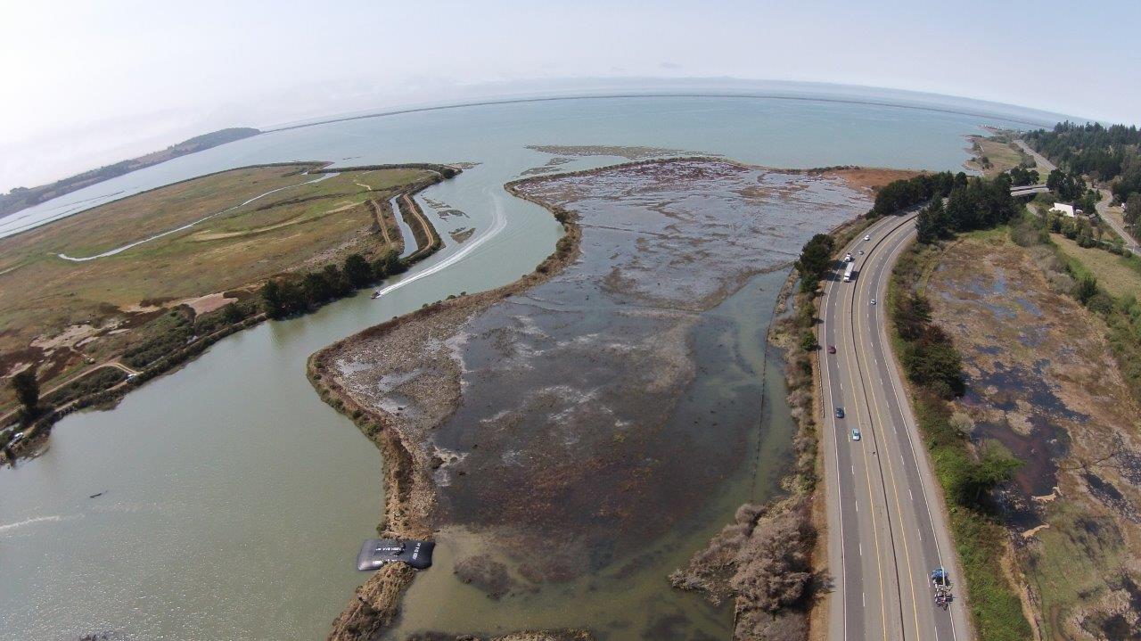
Remember last year when that levee blew out near College of the Redwoods? Water from an extra-high tide rushed in, flooding a 50-acre parcel known as White Slough. It was repaired — quite impressively — with a massive water bag from Scotia-based company Aqua Dam, Inc. (Review all the badass photos from Aqua Dam VP Matthew Wennerholm here.)
That land is owned by the Humboldt Bay National Wildlife Refuge, which had long been aware of the sorry state of the levees on the property. In a press release the refuge folks said, “Other dike sections are severely eroded and expected to fail in the near future.”
The plan, as explained last year by the refuge’s deputy manager, Ken Griggs, has been to launch a full-on restoration project. The idea is to reestablish a “mosaic of tidal, brackish, and salt marsh habitats.”
That project is getting underway tomorrow. Denise Seeger with the National Wildlife Refuge gave the heads-up earlier today in an email saying, in part, “There will be large dump trucks traveling in and out of the area for the next several weeks. For everyone’s safety, please allow extra time and use caution while commuting through the area.”
The project is also aimed at protecting Hwy. 101 and other infrastructure from the rising seas — a problem exacerbated locally by subsidence of the land. A number of agencies — the U.S. Fish & Wildlife Service), Humboldt County Resource Conservation District, State Coastal Conservancy and CalTrans — consulted on the plan, which entails building a “living shoreline,” in part by dumping up to 200,000 cubic yards of fill material in that area by the freeway.
Here’s a press release from the Humboldt Bay National Wildlife Refuge explaining more about the project:
The White Slough Restoration Project will begin construction in South Humboldt Bay in fall 2015 to restore tidal marsh and provide protection of important infrastructure from sea level rise. The White Slough Unit (WSU) of the Humboldt Bay National Wildlife Refuge (Refuge) provides a unique opportunity to regain lost salt marsh around Humboldt Bay.
The WSU currently includes approximately ten acres of un-diked wetlands, 65 acres of diked wetlands – (former salt marsh) which now consists primarily of degraded brackish marsh (60 acres), as well as small areas of freshwater marsh.
The WSU is divided into the West Unit, North Unit, and East Unit. The Project is focused on the West Unit, which consists of approximately 40 acres of diked brackish marsh that has subsided and is currently approximately three feet below sea level.
The dikes were in poor condition when the lands were acquired by US Fish and Wildlife Service (USFWS) in 1989 and restoration to salt marsh has been a goal since a comprehensive management plan was done by the refuge in 2009.
A portion of the dike protecting the West Unit from tidal inundation failed on August 16, 2014. A temporary dam consisting of a heavy duty geotextile woven polypropylene tube filled with water (Aqua Dam) was installed in the breach. Other dike sections are severely eroded and expected to fail in the near future.
Because the area has subsided, dike failure would result in a conversion of brackish marsh to mudflat, and could expose a portion of Highway 101 to increased threat of tidal inundation. The threat of dike failure is also exacerbated by ongoing sea level rise over the past year.
Representatives of the U.S. Fish & Wildlife Service (USFWS), Humboldt County Resource Conservation District, State Coastal Conservancy (SCC), and CalTrans have engaged in discussions about existing conditions and examined potential options to restore and create a larger mosaic of tidal, brackish, and salt marsh habitats.
An important purpose of the project is to create a “living shoreline” which will also protect the Highway 101 road shoulder from erosion by wave fetch and sea level rise. In order to “build” the shoreline, current land surface elevations will need to be raised several feet by placing up to 200,000 cubic yards of clean fill material in the subsided area between the bay and the freeway, and then grade the material to appropriate elevations.
The initial phase (Phase I) will involve the placement of approximately 30-40,000 cubic yards of clean fill to construct a tidal ridge which will divide the project area into separate drainage cells.
Additional fill material will be placed in Phase II of the project and graded to create a mosaic of tidal marsh with salinities ranging from salt to fresh. The tidal marsh will include a network of tidal channels and two depressions with wetlands/ponds fed by a small creek which comes under the freeway. Initial funding for the project has been provided by USFWS and SCC.
This fall the project will be bringing in fill material from both the Bear River Rancheria and the Salt River Restoration Project. This will require significant truck traffic. Community members traveling south to the College of the Redwoods Campus should be aware of increased cross traffic under the Tompkins Hill Overpass.
For further information, visit www.fws.gov/refuge/humboldt_bay/ or call 707-733-5406
Humboldt Bay National Wildlife Refuge Complex, 1020 Ranch Road, P.O. Box 576, Loleta, CA 95551

The Aqua Dam.
CLICK TO MANAGE