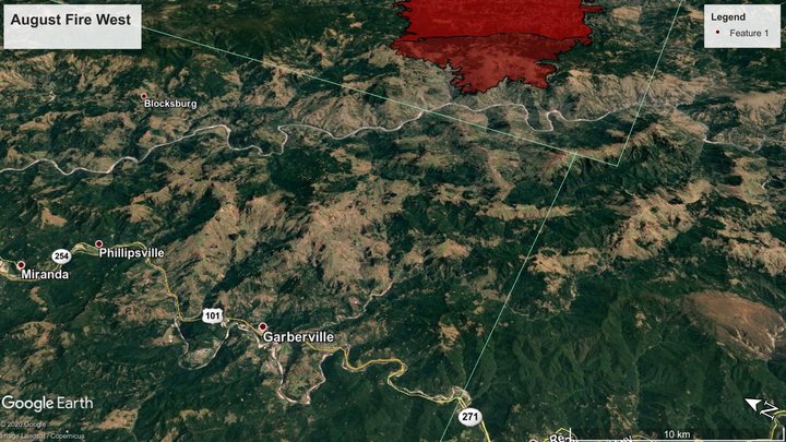
August Complex West. Screenshots from Google Earth, using this morning’s fire boundaries.
As far as Humboldt County is concerned, the news is good from the largest and most threatening of the fires ravaging the region — the August Complex, which is still held to the east side of the Eel River. Evacuation orders have been lifted in Humboldt County.
The complex as a whole stands at around 839,000 acres, with 30 percent containment. The West zone is in the neighborhood of 42,000 acres.
From incident management:
CAL FIRE’S unified team and the U.S. Forest Service are engaged in a coordinated response to take suppressive action on the August Complex, which has been split into three zones to effectively provide a response for the communities at risk. The complexity of four teams managing one fire resulted in some acres being counted twice. Reconciliation of the acreage calculations puts the current acreage of the August Complex West Zone at 42,171 acres. Resources from across the state of California as well as Montana, Utah, Texas, and New Jersey have been assigned to assist on the August Complex West Zone. The fire remained active last night, with moderate fire behavior and isolated torching observed within the fire perimeter. The fire continues to make uphill slope-driven runs when in alignment with topography. A low-pressure system sitting off the west coast will make little progress toward the fire today, resulting in similar weather for tomorrow. Relative humidity will remain low with poor overnight recoveries for the upper slopes and ridge, allowing the fire to remain active through the night.
Follow the August Complex West at Calfire’s incident page.
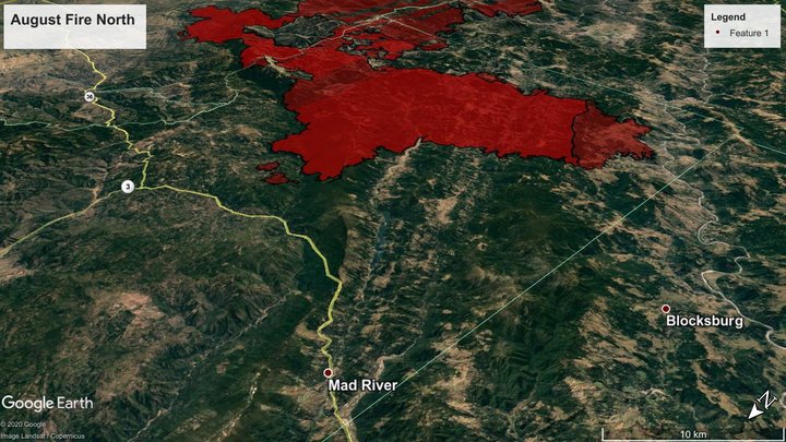
August Complex North.
The news is not quite so good in the August Complex’s North zone, which continues to expand. There have been new evacuation orders in Trinity Pines and Post Mountain areas, both in Trinity County, and — as seen above — the fire continues to perch above Ruth Lake.
From this morning’s briefing:
A cold front will move through the area bringing a slight chance of light showers this evening and tomorrow. Priorities remain on structure defense, indirect line construction (away from the fire’s edge), direct line construction and tactical firing operations (applying fire on the ground to remove vegetation and widen containment lines).
Structure defense continues in Ruth Valley and structure preparation is ongoing in the communities of Hettenshaw and Kettenpom Valleys, Forest Glen and Trinity Pines/Post Mountain. The public is reminded to stay aware of current fire conditions. Please follow all Evacuation Orders and Warnings when they are issued.
The fire spotted to the north of Rattlesnake Ridge and it is a priority to stop the progress north toward Forest Glen, and Trinity Pines/Post Mountain. Line construction continues from Ruth Valley west to the Middle Fork of the Eel River.
Firefighters continue to construct indirect line to Horse Ridge and direct line to the Middle Fork of the Eel River. Direct and indirect control lines from Ruth Lake Road to Mad River Ridge are also being worked on.
On the northeast perimeter (Shasta-Trinity National Forest), good progress has been made and crews continue to reinforce the containment line along the 35 Road using tactical firing operations. Established containment lines in this area are being actively monitored.
Smoke has been preventing the use of aircraft, however yesterday air operations were able to occur on the west side of the fire.
In the Yolla Bolly-Middle Eel Wilderness along Wrights Ridge, the August Complex North and South Zones continue to merge, therefore it is not safe to put firefighters in the area.
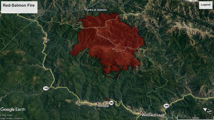
Red Salmon Fire.
The oldest of the currently active fires in the region, the Red-Salmon Complex, was mapped at just over 100,000 acres for the first time, and stands at 19 percent containment. Firefighters are working the southwest corner of the fire to protect Hoopa, Willow Creek and Denny, and on the northeast corner to keep the flames away from the Forks of Salmon community.
From a morning the fire management team’s morning briefing:
Current Situation: Though infrared flights show the Red Salmon Complex growing past 100,000 acres, the gain is largely due to burnout operations in the southwest and northeast corners of the fire. “We’re not letting down our guard,” said Deputy Incident Commander Steve Watkins, “but we’re in a good place. We’re accomplishing our goal of protecting the Hoopa Valley Reservation, Forks of Salmon, and other communities around the complex. We’re getting later in the fire season and hopeful the weather brings relief.” Fireline on the west flank of the complex is in patrol and mop up status. Crews and equipment have been shifted to the southwest of the complex to secure containment around the corner and east. Crews and structure protection remain in Denny and to the northeast in and around Forks of Salmon. A number of hunters on their way to set up camp before the start of the season have been turned away at road closures and other locations. All National Forests in California are closed. Entry is not permitted. Should the statewide closure not be renewed when it expires September 21st, the area closures on the Klamath, Six Rivers, and Shasta-Trinity National Forests remain until further notice.
…
Firefighters have contained the northwest flank of the fire from Red Cap area north along the 10N02 Road along Pack Saddle Ridge and over to Black Mountain area then east toward Whiteys Peak. Along the southwestern and southern flanks, firefighters improved roads and other natural features to create defensive lines to protect the Hoopa Valley Reservation and the communities of Willow Creek and Denny. Our current emphasis in the northeast includes point protection in the area of Forks of Salmon. The focus has been on hand crews, dozers, and water tenders, with smoke, inversions and air turbulence limiting the utility of firefighting aircraft.
Follow the fire on Inciweb here.
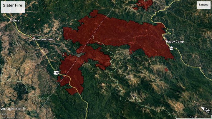
Slater Fire.
Highway 199 is still closed between Panther Flat, north of Gasquet, and the Oregon town of O’Brian, due to the fast-burning Slater Fire, which has burned 143,000 acres between Happy Camp and Cave Junction, and west toward Del Norte County. It is 10 percent contained.
There will be an interactive meeting on the fire’s Facebook page this afternoon at 3 p.m.
Morning update from the incident management team:
NORTH ZONE: Near Gasquet, firelines are holding along Knopki Road, despite limited available resources there. Equipment operators are using bulldozers to establish control lines along Monkey Ridge to prevent the fire from crossing Highway 199.
The Oregon State Fire Marshal’s Office has mobilized 10 task forces of structural fire engines, six from Oregon, three from Utah, and one from Washington State. Today, operations continued to implement direct and indirect fire strategies.
The heavy smoke inversion lifted late afternoon yesterday over the North Zone of the Slater Fire, causing increased fire activity, but fire personnel were able to maintain control lines in and around Illinois Valley. Note to Level 3 evacuees: We are working hard to get you back into your homes. Thank you for your patience as we work to ensure your safety. Northern Rockies Team 2 continues to work with the Oregon State Fire Marshal, Oregon Department of Forestry and other local and federal agencies to contain the northern spread of the Slater Fire.
SOUTH ZONE: A low-pressure system crossed over the Slater Fire area from west to east, clearing smoke out and increasing fire activity yesterday afternoon into last night. Firefighters were able to contain several spot fires on the west side of the Thompson Creek drainage yesterday. Air quality is expected to improve around Happy Camp today, although smoke levels are predicted to remain unhealthy.
Priorities for the Slater Fire South Zone today include preventing rolling material from crossing control lines along Highway 96 and protecting life and property in the Thompson Creek drainage, where fire is backing towards homes. Meanwhile, work continues to build direct and indirect fireline around Seiad to contain the Devil Fire, which spread to the west and northeast yesterday.
CLICK TO MANAGE