PREVIOUSLY:
###
The rubber is meeting the road for the state’s Citizens’ Redistricting Commission, which is charged with drawing up the state’s Congressional and legislative maps. As you’ll recall, every 10 years, after the US Census, state and local governments must redraw the borders of the various political districts they comprise, so as to ensure equal representation.
It’s the job of the Citizens Redistricting Commission — a nonpartisan state body — to draw the lines that make up California’s state Senate and state Assembly districts (there are 40 and 80 of them, respectively) and the districts by which we elected our Congressional representatives (52 this year, down one from the last decade).
Earlier this week, the commission released a series of “visualizations” of the kinds of districts they’re mulling over, and whoo! Those visualizations show that the commission is seriously considering a realignment that has long been feared up here on the North Coast, but never quite realized: The joining of Humboldt County to its beet-red neighbors to the East, rather than the calming blue counties to our south.
Here’s one of the visualizations it has published for a new Congressional lines:
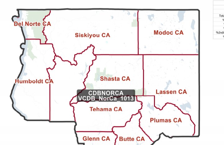
If this becomes the new Congressional district, then we would no longer have Jared Huffman as our representative in the House, as Huffman lives in Napa Marin. It’s unknown who we’d have after the 2022 election for the House, as it’d be a whole new ball game, but currently the Shasta area is represented by something like Huffman’s polar opposite: Rep. Doug LaMalfa, a climate-change denier and a person who refused to certify President Joe Biden’s victory.
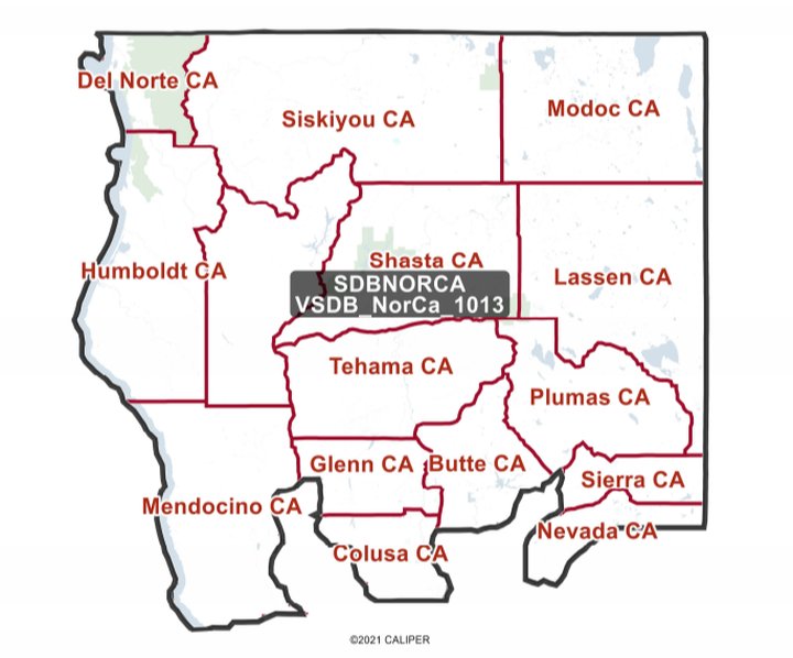
A couple of other visualizations show similar new alignments for our state Senate and Assembly seats. Here’s one of the commission’s Senate visualizations:
And here’s one of its Assembly visualizations:
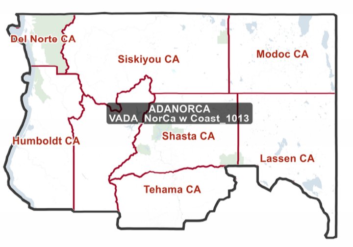
The results here are the same. We would no longer be represented in the state Senate by Sen. Mike McGuire, nor in the assembly by Assm. Jim Wood, as the two of them live in the Santa Rosa area.
These “visualizations” are far from final maps, and the Commission is keen to hear feedback from people in the area. There’s a feedback form at this link — if you want to provide your thoughts, use the name of the maps that are overlaid — “CDBNORCA,” “SDBNORCA” and “ADANORCA,” respectively.
The Commission is also meeting by Zoom to hear feedback from residents of the North Coast and adjacent areas this Friday — Oct. 15 — from 9:30 a.m. to 4:30 p.m. There’s an agenda at this link.
The visualizations we’ve published here are the only ones that specifically include Humboldt County in them, but it’s clear from the entire pack — check them all out in PDF form at this link — of them that a Humboldt-Shasta alliance is not the only possibility on the Commission’s table. Other draft visualizations have Shasta extending farther south rather than west, which would seem to indicate that in those scenarios Humboldt and its southern neighbors would stay intact.
Which would have to be how most Humboldters prefer it. In August, the Humboldt County Board of Supervisors voted unanimously to send a letter to the Citizens’ Redistricting Commission urging it to keep us north-south aligned.
“It is important to distinguish that though we are friends with and have close connections to other northern California counties, we are different from Shasta, Siskiyou, Tehama and other inland counties,” the board wrote. “We ask that this distinctness be recognized In future redistricting maps.” (Read the full letter here.)
Agree? Disagree? If you feel strongly either way, you’d better go ahead and register your thoughts. The Citizens’ Redistricting Commission’s whole purpose is to draw maps that represent the community, and public testimony plays a bigger role than you might imagine.
CLICK TO MANAGE