Ol’ Mr. Sun. Photo by Rajiv Bajaj on Unsplash
###
Rain is a wonderful thing for the plants and animals of the forest, especially after three straight years of drought, but it can be tough down here on the human level. Maybe your experience differs, but in this reporter’s circles people’s behaviors are more and more resembling Jack Nicholson’s, about two-thirds of the way through The Shining.
Here we are nearing the end of April — about halfway through the October-September rain calendar — and we’re sitting pretty at 40 inches of rainfall in Eureka, the first time in ages and ages that we’re actually well ahead of what we used to think of as a “normal” amount of precipitation.
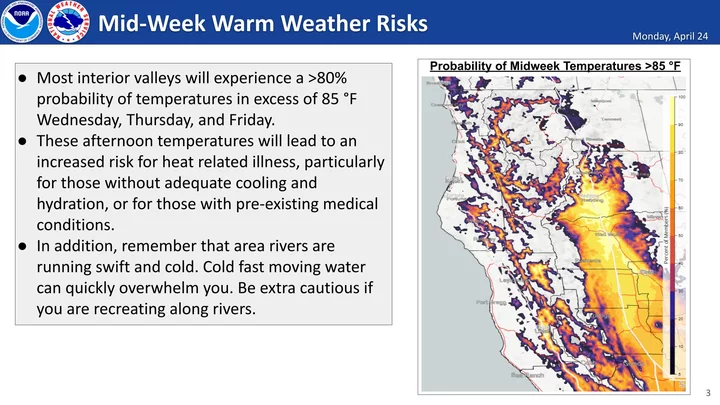
So this is a great time for a little break, and it looks like we’re going to get it! The sun is forecast to shine brightly throughout the next seven days, and we’re even due for a little mini-heatwave on Wednesday, Thursday and Friday. Temperatures on the coast are gonna climb into the 70s, and in the inland areas they could spike all the way into the 90s!
After that: More sun, but chillier.
Here’s how our friends at the National Weather Service office on Woodley Island phrase it, in this morning’s Area Forecast Discussion:
SYNOPSIS…A warming trend will occur across Northwest California through mid week, with interior valley high temperatures climbing into the 80s and ranging to the 60s and 70s along the immediate coast. Thereafter, cooler temperatures along with showers and thunderstorms will become more probable this weekend into early next week.
Eat, drink, be merry. Enjoy the sunshine while it lasts.
Graphic: National Weather Service, Eureka.


CLICK TO MANAGE