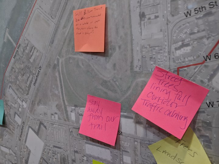
Organizers asked attendees at last night’s public outreach session at the Wharfinger to place sticky notes with suggestions on blown-up maps of the Broadway corridor.
###
PREVIOUSLY:
###
Last night, the multiagency coalition that’s looking to create a master plan for traffic improvements in the south end of Eureka made clear to a crowd at the Wharfinger Building that it’s still considering a long-thought-dead scheme to build a whole new road through the city’s waterfront greenbelt in order to relieve traffic congestion on Broadway.
That plan – which had been known as the “Waterfront Drive Extension Project” — was last considered by the Eureka City Council in 2012, but had been burbling about government for many years before that. It would involve major road construction near or through the Palco Marsh and the city-owned “Parcel Four,” behind the Bayshore Mall, creating a north-south thoroughfare between Broadway and what is now the Waterfront Trail.
Many have been under the impression that strong opposition from the state Coastal Commission, and also from many local residents, had killed the project years ago. But last night, at the first public meeting of the new grant-funded coalition between the city, Caltrans and the Humboldt County Association of Governments to tackle Eureka’s Broadway Problem, it was back on the table – at least for argument’s sake.
Humboldt Baykeeper had gotten word that this was the case and had put out an action alert to its members, who evidently had responded. At the opening of the two-hour meeting, during which organizers mostly hoped to solicit public input that will guide the development of a new Broadway corridor master plan, one of the emcees – Kendall Flint of Regional Government Services – addressed the controversy.
“I just wanted to make sure everybody’s clear – some folks have said, ‘Hey, I thought we’ve already decided against this, or for this, or whatever,’” Flint told the dozens of people who gathered at the Wharfinger. ”So I just want to make sure we’re on the same page. For tonight’s meeting, nothing has been set. There’s nothing that is solid, there’s nothing that’s off the table or on the table.”
The current phase of the current project is the time for blue-sky thinking to address Broadway woes. As Jim Damkowitch, a project manager for the engineering firm GHD attached to the project, told attendants that they’re looking to come up with a master vision about the problems on the Broadway corridor and a list of complementary, interlocking projects that together will together make up the solution to those problems. A master plan with specific proposals is expected to be released in about six months.
But last night’s meeting was for public outreach, and that took two forms. Attendees were asked to stick color-coded Post-it notes to large maps depicting various stretches of the Broadway corridor, noting particular problem areas or places of concern. Then they were invited to participate in live polling on a variety of questions.
Most of those questions had to do with traffic and congestion on various stretches of Broadway, and most of those questions were broken up into four subcategories — vehicle transportation, pedestrian walkability and bikeability, and public transit. There was broad consensus on these questions in the room: Broadway is too congested, there aren’t enough pedestrian crossings, and it’s too dangerous to bike (and why would you, anyway, with the bike trail available on the waterfront?)
But attendees at the meeting often interrupted polling to give voice to concerns that weren’t included in the questions being polled. Several people said that the biggest problem with Broadway is blight, or just general ugliness.
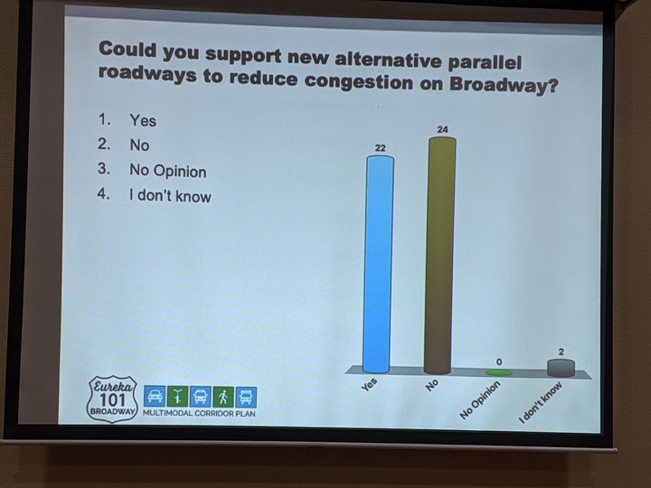
The last phase of the polling session gauged attendees’ reaction to specific solutions. One of the questions was “Could you support new alternative parallel roadways to reduce congestion on Broadway?” Reaction was evenly split:
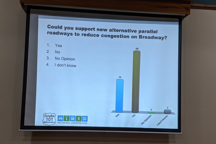
However, after the vote was taken several people asked for clarification — were organizers asking specifically about new roads through the waterfront greenbelt, to the west of Broadway? Organizers confirmed that yes, that is specifically what the question was intended to ask. When the audience protested, they agreed to poll the question again, and got different results:
Again: It’ll be half a year or so before a new master plan for the corridor — with specific proposals — is released.
In the meantime: If you didn’t make the meeting last night, there’s still time to tell the project coordinators about your own issues and concerns with the Broadway Corridor. Click here for the “Eureka Broadway 101 Multimodal Corridor Plan” website, then look for the “Interactive Map Tool” link. (It’s here.) Once you’re on the map, you can drop pins on particular locations to describe problem locations on the Broadway Corridor, traffic-related or otherwise.
CLICK TO MANAGE