A white cross once perched atop the cliffs above Centerville Beach, but it had to be rescued in 2017 as erosion threatened to topple it. | File photo by Penny Powers.
###
It’s called the Lost Coast for a reason.
The steep and crumbly oceanfront cliffs of the King Range repelled the builders of California’s Pacific Coast Highway, forcing a retreat to firmer ground inland — thereby ensuring that the region would remain isolated and remote. A new study confirms that this decision was a good call, since the Lost Coast contains the most rapidly eroding stretch of coastline in the state.
The study and a corresponding map, created by researchers at UC San Diego’s Scripps Institution of Oceanography, were completed using high-resolution LiDAR datasets to measure erosion along 538 miles of California’s coastal cliffs between 2009 and 2016.
The highest erosion rates were observed along the North Coast, with “erosional hotspots” pinpointed in Mendocino, Humboldt and Del Norte Counties. Nowhere in the state showed a higher erosion rate than Centerville Beach, five miles west of Ferndale.
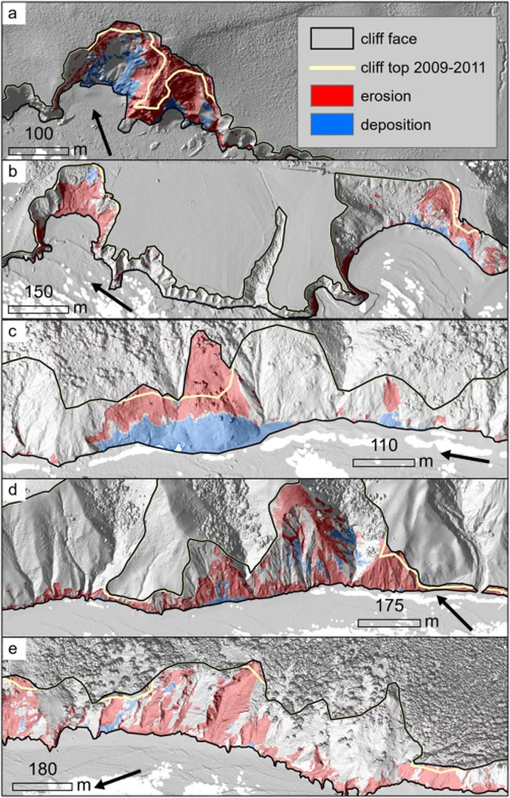
Examples of change detection near a) Point Arguello, b) Martin’s Beach, c) Usal Beach, d) King Range, and e) Centerville Beach area. | Creative Commons License.
###
“It’s probably the largest high-resolution cliff erosion study ever conducted, and provides the first detailed erosion rates for several parts of the state,” said coastal geomorphologist Adam Young of Scripps Institution of Oceanography at UC San Diego. The study was published in the journal Geomorphology, and the results were turned into a searchable website.
Longtime readers of the Outpost may recall some of our prior coverage of the crumbling cliffs above Centerville Beach, including the successful 2017 effort to rescue a historic cross from the precipice and the time in 2019 when major cliffside collapses renewed concerns about the integrity of the county road above.
PREVIOUSLY:
- (VIDEO, PHOTOS) Recent Erosion Leaves the Centerville Beach Cross Teetering on the Edge of a Cliff
- (VIDEO, PHOTOS) Hallelujah! Centerville Cross Rescued from Cliff’s Edge
- (VIDEO) Slides Continue to Wallop Centerville Beach, Threatening the Roadway Above
###
The L.A. Times reported on the study’s findings earlier today, noting:
The consequences of cliff erosion have already proven to be severe on major roads, railways and other critical infrastructure, and coastal officials have increasingly turned to scientists for help. A recent cliff collapse that killed three women has also intensified the pressure to better understand this hazard looming over much of the California coast.
Like hurricane forecasting, projecting when and how much a cliff will erode — especially in the face of sea level rise — is in high demand. But coastal cliffs are infamously difficult to study, and the data that scientists need to feed into these forecasting models have been few and far between.
Image from the Coastal Cliff Erosion Viewer from UC San Diego.
###
What makes our local coastline so unstable? Adam Young, a coastal geomorphologist who oversaw the study, told the L.A. Times that the reasons aren’t fully known, but the North Coast tends to have heavier rains and bigger waves while Southern California’s coastline is more urbanized and armored with seawalls and other structures to prevent erosion.
You can access the whole study via this link. And you can relive some of the erosion of Centerville Beach’s cliffs in the 2019 video embedded below.


CLICK TO MANAGE