
(PHOTOS) The Stranding and the Rescue of the Fishing Vessel Miss Jessie, Which Grounded Itself on the South Spit Friday Morning
Hank Sims / Monday, July 28, 2025 @ 11:34 a.m. / Emergencies

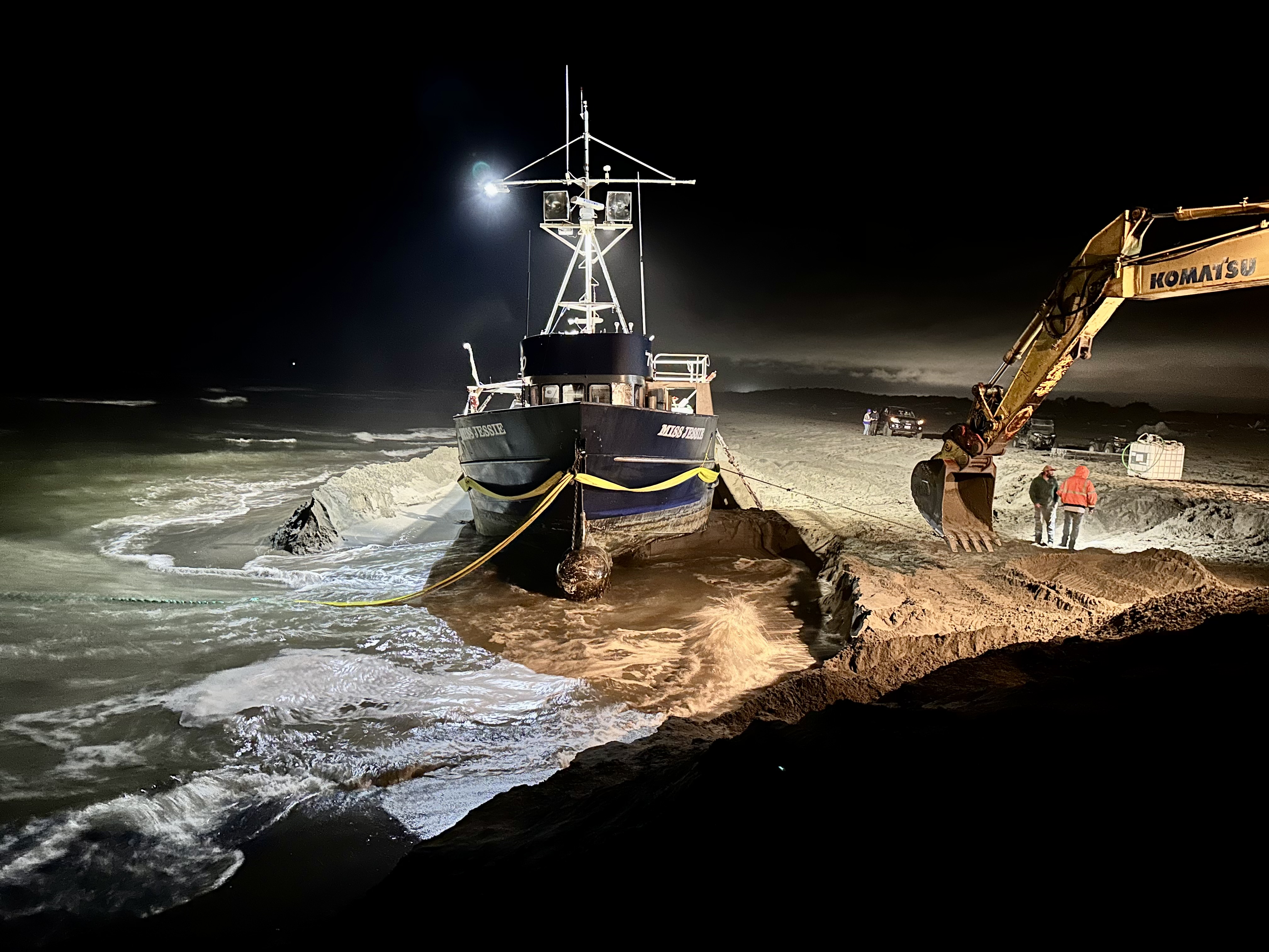
High and dry. Photo: US Coast Guard.
Oh were it mine with sacred Maro’s art
To wake to sympathy the feeling heart,
Then might I, with unrivaled strains deplore
Th’ impervious horrors of a leeward shore.
— William Falconer, The Shipwreck
We don’t feel the impervious horrors of the leeward shore as once we did, now that we have diesel engines and metal hulls, but still it’s no fun to run aground, even on the soft, soft sand of the South Spit.
The U.S. Coast Guard was called in the wee hours of Friday morning to pluck five folks off the stranded hulk of the Miss Jessie, which had beached itself like a dying humpback for reasons unspecified.
This is what the Coast Guard had to say about that, but stick around after the jump for what happened after.
Press release from the United States Coast Guard Southwest District:
The Coast Guard rescued five people aboard the 37-foot commercial fishing vessel “Miss Jessie” after it ran aground south of Humboldt Bay near Eureka, California, Friday morning.
Coast Guard Sector Humboldt Bay watchstanders received the report at 12:02 a.m. via VHF-FM channel 16 from a crew member aboard the fishing vessel, requesting assistance after the vessel became disabled in the surf and ran aground.
Watchstanders issued an urgent marine information broadcast and coordinated the launches of an Air Station Humboldt Bay MH-65 Dolphin helicopter aircrew and a Station Humboldt Bay 47-foot Motor Lifeboat crew.
The helicopter aircrew arrived on scene at 1:27 a.m., hoisted all five people off the vessel and transported them to the Samoa Field Airport over two separate trips.
The vessel’s fuel tanks have a maximum capacity of 7,000 gallons, and there is an estimated 800 gallons of diesel onboard.
No injuries or pollution have been reported.
###
Rescuing the mariners was relatively easy. The Miss Jessie herself? Not so much. According to an informant on the scene who wishes to remain anonymous, and who sent the pictures below, a team assembled to work round-the-clock to float the boat again.
This team included personnel from Figas Construction, Corbet Diving and Zerlang & Zerlang Marine Service, and it had to put together a whole land-sea plan to coax the Miss Jessie back into open water. This involved carving a huge ditch into the sand, waiting for the tide to come in, then pulling like hell with an offshore tugboat.
“Good example of decades combined experience, and roughneck elbow grease at work to do something really cool, and return the beached boat to its owners,” our informant says. Agreed!
Enjoy his photos of the operation below.



BOOKED
Today: 10 felonies, 12 misdemeanors, 0 infractions
JUDGED
Humboldt County Superior Court Calendar: Today
CHP REPORTS
1656 Union St (HM office): Missing Indigenous
ELSEWHERE
County of Humboldt Meetings: Behavioral Health Board - SUD/Dual Recovery Committee - Sept. 10, 2026
County of Humboldt Meetings: Behavioral Health Board Executive Committee Meeting - July 1, 2026
RHBB: Judge Overturns Search Warrant in Student Activist Case: Devices Ordered Returned
RHBB: Multi-Vehicle Crash Closes South Fortuna Boulevard Near Strongs Creek Plaza
FIRE UPDATE: Butler Fire Hits 21,000 Acres; 38 Percent Contained
LoCO Staff / Monday, July 28, 2025 @ 9:52 a.m. / Fire
###
Press release from Six Rivers National Forest:
Orleans Complex Incident Update
Size: 21,070
Percent Contained: 38%
Personnel: 1,880
CURRENT SITUATION:
YESTERDAY – Predicted thunderstorms did not materialize yesterday as predicted, and crews reinforced control lines throughout the fire area. In the northern area from Orleans Mountain to Pollack Gulch remained quiet as crews added more depth to current containment lines and added additional containment around Salmon River Road and Quail Ridge. In the southeastern area near Cecilville, crews continue to experience large amounts of debris in the roadways and are assessing methods to remove hazards in effort to ensure safe travel. Control line has been extended west of Knownothing Creek to the 10N07 Road along the highpoint ridge. Westward in the areas of Lunch Creek and Horn Creek, crews coordinated waterdrops to lower the fire intensity of interior fuels within the containment lines.
TODAY – Crews will remain on high alert for new starts and increased fire activity due to predicted dryer conditions and thunderstorms over the fire area today. Firefighters will be scouting containment options west of Lunch Creek while continuing suppression actions towards Nordheimer, the wilderness boundary, and previously burned Red Salmon Fire area. In the east, crews will continue to brush roads to open access on the 39 and 39N30 roads east of Cecilville Road near Godfrey Ranch.
Debris (falling rock and hazard trees) on road systems remains of heightened concern, creating hazards to emergency response personnel, visitors, and residents. Reopening Sawyer’s Bar and Salmon River Roads remains a top priority for incident managers, and crews will continue to focus their efforts to reopen those roads by conducting hazard tree and debris removal activities.
WEATHER – A slight warming trend begins today with temperatures climbing the daily maximum a few degrees each day, beginning at an expected 90-93 degrees today. Very low relative humidities in the teens will cause substantial drying and create a high probability of ignition of new starts. Similar winds are expected in the valleys, upslope 3-5 mph, up-valley 5-10 mph out of the northwest with potential gusting up to 18 mph. The predicted path of storms now covers the Butler Fire area, as well as the Etna base camp, beginning early in the afternoon. These predicted storms could bring lightning and erratic winds, causing fire behavior to increase.
EVACUATIONS: There are evacuation orders and warnings in the immediate vicinity of the fire. For current evacuation status, visit www.facebook.com/SiskiyouCountySheriff and www.facebook.com/SiskiyouCountyOES. Additional evacuation information and a map can be found on the Genasys site at https://protect.genasys.com/search?z=14…
CLOSURES: An official forest closure around the Orleans Complex went into effect on July 16th. Hikers are not permitted and will be asked to leave the area. For details and a map of the closure area, please visit https://www.fs.usda.gov/…/SRF%2010-25-09%20KNF%2025-05.
FIRE RESTRICTIONS: Forest fire restrictions are currently in effect. Please visit the local forest pages for more information: Klamath National Forest: https://www.fs.usda.gov/r05/klamath/alerts and Six Rivers National Forest: https://www.fs.usda.gov/r05/sixrivers/alerts.
###
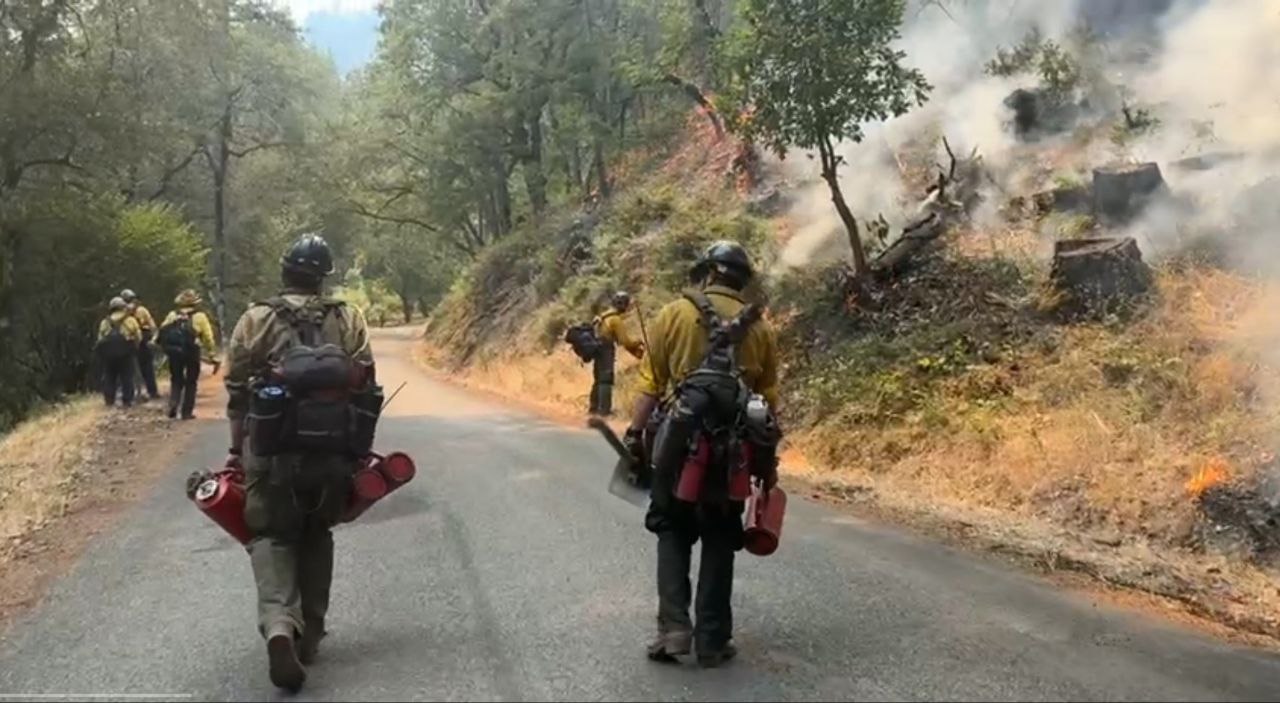
Engine crews conducting strategic firing operations along Cecilville Road. | Photo: Six Rivers National
As Trump Takes on Education, Candidates Line Up for State’s Top Schools Job
Carolyn Jones / Monday, July 28, 2025 @ 7 a.m. / Sacramento

Former speaker of the Assembly Anthony Rendon at the dais on May 31, 2022. Photo by Miguel Gutierrez Jr., CalMatters
###
This story was originally published by CalMatters. Sign up for their newsletters.
###
As California intensifies its fight with the Trump Administration, the race for the state’s top schools job is becoming ever more crowded.
Today, former Assembly Speaker Anthony Rendon formally entered the race to succeed Tony Thurmond as State Superintendent of Public Instruction. He joins a host of other state lawmakers and local school board members vying to replace Thurmond, who terms out in 2026 after eight years on the job.
The next state superintendent faces daunting challenges. The most urgent priority may be responding to President Donald Trump’s funding cuts and policy shifts, including the dismantling of the U.S. Department of Education and increased immigration enforcement. Those policies will have a deep impact on thousands of California’s 5.8 million K-12 students, at least 20% of whom have at least one parent who lacks legal status, according to the Children’s Partnership, a policy and advocacy nonprofit.
“There’s no question the Trump administration is going to continue to weaponize K-12 education,” said Morgan Polikoff, an education professor at the University of Southern California. “The state superintendent can serve as a buffer, helping districts navigate funding cuts and policy changes while continuing to push against the Trump administration. It’s important that California keeps fighting.”
From the classroom to the Legislature
Rendon, a Democrat from Lakewood, spent 12 years in the Legislature, the last eight as speaker. While he was speaker, the state nearly doubled its K-12 funding and introduced a new grade, transitional kindergarten – a particular priority for Rendon, who started his career as an early education administrator.
A former UC regent, Rendon said he’d try to protect California schools from Trump’s policies, particularly those related to immigration, but also work at the state level to advocate for more funding and accountability.
“California has the best public universities in the world,” Rendon said. “We need to have the best K-12 schools in the world, too.”
Vague job duties
California has a murky hierarchy when it comes to schools. The governor, Legislature, State Board of Education and superintendent all share duties, but the superintendent has the least amount of power. The superintendent oversees the California Department of Education, but California also has a system of local control, which means local school boards have plenty of latitude over day-to-day operations. Superintendents often find themselves balancing the needs of at least a dozen stakeholders, with not much power themselves.
In 2023, a bill by former Assemblymember Kevin McCarty would have banned state superintendent elections altogether, turning the position into a governor-appointed role, like it is in 41 other states.
Still, despite very limited authority, state superintendent can be an important job, said Julie Marsh, a professor at USC and executive faculty director for Policy Analysis for California Education, a research center. Despite the obstacles, the state superintendent oversees the largest, most complex school system in the U.S. and has a wide platform to “do something good.”
“They can’t create policy, but they can help set the agenda. They can use their bully pulpit to defend the policies and values that Californians overwhelmingly support,” Marsh said.
Muratsuchi jumps in
Assemblymember Al Muratsuchi, chair of the Assembly education committee, is also running for superintendent. An adjunct professor at El Camino Community College and former school board president at Torrance Unified, Muratsuchi has a long history of advocating for schools.
He’s authored numerous school bills, including AB 49, which would make it harder for immigration agents to enter schools, and AB 477, which would increase state education funding and raise salaries for teachers and other school staff. He was also the lead author of Proposition 2, a $10 billion school facilities bond that passed last year.
As state superintendent, Muratsushi said he’d continue to push for more funding while standing up to the Trump administration.
“As California’s top elected education leader, the state superintendent should have a strong record of fighting Trump’s attacks on public education and our most vulnerable students,” said Muratsuchi, a Democrat from Torrance. “I believe I’m that person.”
Newman enters race
Muratuchi’s former counterpart in the state Senate is also running for superintendent. Josh Newman, a Democrat from Fullerton who served as chair of the Senate education committee from 2023-24, said that in addition to fighting Trump he’d focus on students’ physical and mental health, boosting civics education and revitalizing the Department of Education.
Accountability and compliance should be a priority, he said.
“We’ve increased funding substantially in California for 20 years, yet we haven’t seen a corresponding increase in test scores or a narrowing of the achievement gap,” Newman said.
“That points to a systemic issue where the superintendent and Department of Education must play a bigger role.”
Shaw looks beyond Chino
Sonja Shaw, president of the Chino Valley school board, made national headlines for her attempts to require school staff to notify parents if a student identifies as transgender. Thurmond actually attended a Chino Valley board meeting to oppose the measure, and she had police escort him out.
Now, Shaw is running for Thurmond’s job, saying she wants to take her fight statewide.
“Parents want schools to focus on reading, writing and math, not social justice and LGBTQ ideology,” said Shaw, a Republican. “I feel like we can take this fight beyond Chino.”
Several other candidates have also filed initial paperwork with the Secretary of State, including two members of the Los Angeles Community College District: Nichelle Henderson and Andra Hoffman.
The state superintendent position pays $194,587 annually.
OBITUARY: Donald Eugene Schmitter, 1944-2025
LoCO Staff / Monday, July 28, 2025 @ 6:56 a.m. / Obits

Donald
Eugene Schmitter
April
3, 1944 - April 16, 2025
Donald Eugene Schmitter, age 81, passed away peacefully on April 16, 2025. He was a resident of Rio Dell, California, since 2021. He was born on April 3, 1944, in Kansas City, Missouri, to Dorothy Lorene (Anderson) Smay and Norman Schmitter. He was lovingly raised by his father, Noel Eugene Smay, who raised him as his own son.
Donald was preceded in death by his parents; his sister, Sandra (Schmitter) Kerr; and his beloved daughter, Rebekka Schmitter. He is survived by his loving wife, Ruth Schmitter, whom he credited with “saving his life.” He also leaves behind his sister Terry (Smay) Cuadras; brother Gary Smay and his wife Dorothy; and sister Toni (Smay) Habets and her husband Keith.
Don was the quintessential “free spirit” who approached life with his whole heart and sometimes with little regard for common sense. He was a true lover of animals, especially his cherished little dog Tilly, who preceded him in death. Tilly’s ashes will be spread with his, a testament to their special bond.
Donald was an incredible artist, particularly gifted in pen and ink, creating works that reflected his unique perspective on the world. Throughout his battle with cancer, Don’s deep faith in God provided him strength and comfort.
Don was someone who, once you met him, you would never forget. He will be remembered dearly as a devoted husband and beloved big brother whose free spirit and generous heart touched all who knew him.
###
The obituary above was submitted on behalf of Donald Schmitter’s loved ones. The Lost Coast Outpost runs obituaries of Humboldt County residents at no charge. See guidelines here.
OBITUARY: Patricia Ann Fales, 1969-2025
LoCO Staff / Monday, July 28, 2025 @ 6:56 a.m. / Obits

Patricia Ann Fales
December 22, 1969 - May 25, 2025
Tricia came into this world with an extra portion of exuberance. She was energetic, curious, and found joy everywhere.
She loved all life, especially her dogs, most recently Paladin.
She was kind and helpful. She believed deeply in the power of gratitude and generosity and live her convictions daily. She was known for her cards and tokens of thanks throughout the community.
Tricia lived most of her life in Ferndale, where she was a beloved member of the community.
She was taken abruptly. She is finally pain-free.
She is preceded in death by her numerous dogs and her mother, Susan Fales. She is survived by her father, Bill Fales, her sister, Barbara Fales, and her niece, Rachael Fales. She is also survived by her chosen grandchildren, Zaia, Forrest, Kamaile and Weston Ziganti.
Services will be held at Our Savior’s Lutheran Church in Ferndale at 10:30 a.m. on August 16, 2025 with light lunch following.
A Celebration of her life will also take place in Fortuna at Miranda’s Rescue at 2 p.m.
Donations can be made in Tricia’s honor to:
Catherine Ponder’s Unity Church Worldwide
Ferndale Museum
Miranda’s Rescue
###
The obituary above was submitted on behalf of Patricia Fales’ loved ones. The Lost Coast Outpost runs obituaries of Humboldt County residents at no charge. See guidelines here.
Wanted Felon Shot Dead Near Blue Lake in Standoff With Humboldt County Sheriff’s Deputies, Agency Reports
LoCO Staff / Sunday, July 27, 2025 @ 9 a.m. / Crime

Photo by Gena Bernabe.
###
Press release from the Humboldt County Sheriff’s Office:
Humboldt County, CA– On July 26, 2025, at approximately 8:00 p.m., Humboldt County Sheriff’s deputies responded to the 1300 block of Glendale Avenue near Blue Lake to serve an arrest warrant on a suspect wanted for felon in possession of a firearm. The suspect was also wanted in connection with a brandishing of a firearm incident that had occurred earlier in the day.
While deputies were staging in a private parking lot near the location, they observed the suspect walk into the roadway in front of them. Deputies pursued the suspect on foot eastbound, where he fled into nearby bushes on the north side of the street. Deputies surrounded the suspect and gave commands for him to surrender.
At that time, an officer-involved shooting occurred. Multiple deputies discharged their service weapons at the suspect. Following a brief standoff, deputies approached, secured the suspect and his firearm, and immediately began rendering life-saving aid. Emergency medical personnel arrived on scene and continued life-saving efforts. The suspect was transported by ambulance to a local hospital, where he was pronounced deceased. The suspect’s name is being withheld pending notification of next of kin.
Per Humboldt County protocol, the County Critical Incident Response Team (CIRT) has been activated to investigate this incident. The Humboldt County District Attorney’s Office will lead the investigation with the Humboldt County Sheriff’s office, with assistance from investigators representing multiple allied law enforcement agencies. The 1300 block of Glendale will be shut down for several hours while evidence technicians process the crime scene.
This remains an active and ongoing investigation, and only limited details are available at this time. Additional information will be released as it becomes available and as the investigation moves forward.
Anyone with information related to this incident is asked to contact the Humboldt County Sheriff’s Office at (707) 445-7251 or the Sheriff’s Office Crime Tip Line at (707) 268-2539.
SPRINTING ACROSS AMERICA: Week 13! An Interlude at the National Parks of the Great Mountain West
Tom Trepiak / Sunday, July 27, 2025 @ 7 a.m. / Sprinting Across America
Seattle is just on the horizon for the final ballpark of the tour! Between Game #29 and Game #30, however, we managed to visit five national parks and a national memorial. (There are more national park reviews in Week Two.)

Not so bad. All photos: Trepiaks.
National Park #6: Badlands in South Dakota
Rattlesnakes. Prairie dogs. Bighorn sheep. Bison. If you want it, here it is, come and get it! Badlands National Park is more than just rugged terrain with unusual rock formations. Explore the Badlands Wilderness Area and you find wildlife. Some of which you would rather not! “BEWARE Rattlesnakes!” greets you at each trailhead. The visitors center gives a brief lecture on what to do if you come across rattlesnakes. The answer: It depends! Stomp your feet if you aren’t close enough for them to strike you. Rattlesnakes feel vibrations in the ground and will scurry off when they feel it. Unless they feel threatened, in which case they will strike.
PREVIOUSLY:
All dispatches from the Sprint can be found at this link.
Fortunately, we did not come across any rattlesnakes. We did see prairie dogs and barely saw bighorn sheep. The sheep blend in with the rocks. If you don’t see a profile emerging above the rocks, you might miss them entirely.
“This place is pretty awesome,” said Joe Livingston from Iowa. “It’s a destination for those of us in the Midwest. This is where my folks came for their honeymoon. We’ve always heard about the Badlands. It’s beautiful with the layers and ruggedness.” He was last here in 2002 when a hike to the bottom revealed temperatures 20 to 30 degrees hotter than the overlook. There is a 60-mile-long wall of carved hill that divides the upper from the lower prairie. Is there anybody out there? The Wall is the geologic feature around which park boundaries were drawn.

In case you forgot to beware for one second.
There are many hiking trails (BEWARE Rattlesnakes!), but a 30-mile drive will take you to a variety of overlooks to catch the striking beauty and the dichotomy of grassy fields and rugged rocky terrain. We used a self-guided tour on the National Parks (NP) App that took us to four overlooks and a short hike. The Yellow Mounds Overlook is the most colorful place in the park, with purple, yellow, greens and striped reddish beds. My wife was bemused with sunflowers sprouting out in odd places. “Sunflowers are growing out of rocks,” she said. “You’d think I could grow them in my garden.”
BADLANDS STATS: It is 382 square miles. In 2024 there was an average of 2,998 visitors a day.

Rock-for-brains.
National Memorial: Mount Rushmore in South Dakota
The last time I was at Mount Rushmore, things were much different. There was a viewing platform thousands of feet from the presidential heads of stone. The presidents looked far away. Tiny, even. Fast forward from 1978 to today, and now George, Tom, Teddy and Abe are up close and personal, just 1000 feet away from the Grand View Terrace. And all the related memorial infrastructure that has been built since – parking garages, visitors centers, an amphitheater and more – is also raised up. You are closer east to west, and you are at a higher elevation. Why these four presidents? The Mount Rushmore literature says Washington represents the nation’s founding, Jefferson its expansion, Lincoln its development, and Roosevelt its preservation. The heads are 60-feet high and took 14 years to complete.
I posed the following question to a few random folks on the Grand View Terrace. If you had the power to remove one president and add a different president, who would you take off and who would you add and why?
Ryan Kotopka of Florida was the first to weigh in. “I’d take off Teddy. He’s the one most people wouldn’t know. I would add JFK. He’s one of the most known. Everyone knows where they were when he was assassinated. If he was able to complete two terms, he’d already be up there.”
Hannah Worby of New Jersey had an entirely different take. “Take off Jefferson. For all the wonderful things he did, there are some abominable things he did. We don’t talk about his slave ownership and all that it entails. I would add FDR. He set a standard for how we should care for one another in terms of social support. He showed how government can do good for its citizens.”
Seven-year-old Huxley from South Dakota doesn’t like that Lincoln wore “a really big hat.” It did not concern him that Lincoln’s depiction on Mount Rushmore does not include a hat.
Rachel & Michael Ludwig from Michigan finished each other’s sentences, so we will include their comments together as one. “Take off Roosevelt. He’s the least of the monumental; not as ground-breaking. Put Barack Obama up there. He did important things for our country. History will value the memorable things he did.”
MOUNT RUSHMORE STATS: It is located in the Black Hills of South Dakota. The memorial park is two square miles. In 2024 there was an average of 5,069 visitors a day. It will cost you $10 to park there ($5 for seniors). National Park passes are not valid at the memorial.
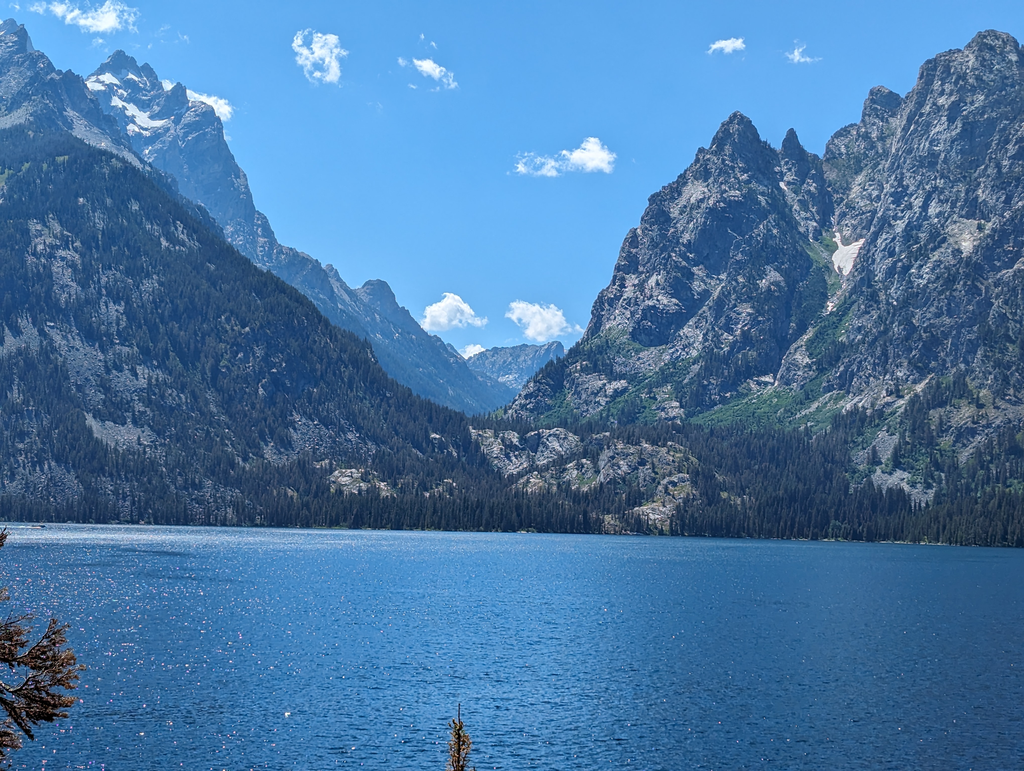
Jenny Lake in the Grand Tetons.
National Park #7: Grand Teton in Northwest Wyoming
If you go to Yellowstone, treat yourself to a visit to Grand Teton National Park which borders Yellowstone to the south. The Teton Range is stunning, still with snow decorating its highest elevations on a mid-July day. A road – the John D. Rockefeller Jr. Memorial Parkway – cuts through the park, providing many opportunities for overlooks, turnouts and walkabouts to breathe in the beauty. Our favorite stop was the Jenny Lake Overlook. Jenny Lake is at the base of the Teton Range in the Cascade Canyon, and the colors are striking with the aqua blue water of the lake and the backdrop of the blue sky over the stately mountains dabbled in snow. There must have been 8,675,309 shades of blue.
“For years I watched a lot of YouTubers and TikTokers post about Grand Teton,” said Samantha Stephenson, a college student from Duluth, Minnesota. “It’s even more beautiful in person. I love it. It’s larger than life.” Stephenson has been to Yellowstone twice before, but this was her first visit to Grand Teton.

Schwabacher Landing.
We also recommend the Schwabacher Landing (not to be confused with the Schwarber Landing in the right field bleachers at the All-Star Game earlier this month in Atlanta) where you can take a short hike to find the mountains reflected in a crystal-clear channel of the Snake River, outlined with wildflowers. And if you time it right (dawn or dusk), you might see beavers at work building dams in the river.
GRAND TETON STATS: It is 484 square miles. In 2024 there was an average of 9,940 visitors a day. Grand Teton is the highest mountain of the Teton Range at 13,775 feet.
National Park #8: Yellowstone in Wyoming (and a little bit of Montana and Idaho)
The National Park of national parks. So diverse. So large. So little time! If you come here, plan on spending days to see what Yellowstone has to offer. We spent four nights and saw a lot, but there was so much more. You can learn from our mistakes. Yellowstone has almost 100 miles of road from top to bottom and another 100 miles of road from side to side. Our No. 1 tip: Reserve campgrounds in different parts of the park for each night of your stay. That way you won’t be doubling back to your campground after driving 40 miles in one day, like we did.
Camping at Bridge Bay or the RV Park in nearby Fishing Bridge in the southeast part of the park is probably worthy of a two-night stay. Abundant wildlife and Yellowstone Lake are the primary draws to this area. Camp in the southwest area for your geyser visit, including Old Faithful. Camp in the northwest area for a visit to Mammoth Hot Springs, then another night of camping in the northeast to see the Grand Canyon of the Yellowstone and to participate in a Wild West Adventure (more on that later). If you only have four nights, use a day trip from the southeast side to visit the canyon.
Yellowstone is smartly laid out with what they call villages throughout the park. Each village has a general store and a gas station (some with diesel!). Six of the 10 villages include a visitor’s center. There is limited cell phone service and very limited Wi-Fi. Grant Village and Lake Village (both in the southeast) have the best cell phone coverage. Mammoth Hot Sprints visitor’s center in the northwest and some of the hotels have Wi-Fi. The general stores and visitor centers all sell bear spray at about $60 a can. Or you can rent a can of bear spray for the afternoon at various locations for $16.
The roads through the park are mostly 45 mph and have plenty of turnouts, lookout points and strategically located restrooms. Prepare for a wide range of temperature in the summer. Days are in the low 80s and nights are high 30s. Yellowstone’s elevation near Yellowstone Lake is more than 7,700 feet, so be prepared for possible elevation sickness. The good news is that it wears off after about 24 hours. The bad news is your first night is likely to be a rough one if you are susceptible to this. If you aren’t sure, the most telling sign is that you just don’t think you’re getting enough oxygen and you feel like you might pass out if you lay down flat.
First on our agenda was to see some wildlife. We thought rising early would be an advantage but found out this was not necessary. You will have a close encounter of a buffalo kind just driving around the southeast area. Hayden Valley is a good spot to see large herds of buffalo but you can spot solo males just about anywhere. On a hillside. In a parking lot. In the middle of the road. As we were driving back from Hayden Valley, we encountered a true Yellowstone traffic jam. One buffalo walking right down the middle of the road on the broken yellow center line. Cars stopped on both sides of the road. Occasionally he would go to one side of the road, allowing cars to drive by on the other side. But he seemed most content straddling the yellow line.


Acts like he owns the place.
It begged the age-old question: Why WOULDN’T the buffalo cross the road? Some possible answers: 1. If you’re the size of a buffalo, you get to choose if or when you cross the road; 2. There was no chicken to follow; or 3) The buffalo may be thinking, “There’s something happening here. But what it is ain’t exactly clear.”
We learned at our ranger talk by Lisa Davenport that the males are the ones wandering solo and the females are in the herd with the babies and yearlings. Males weight about 2,000 pounds, or about the same as a Mitsubishi Mirage automobile. Both males and females have horns – not antlers. Buffalo have one calf per year. They live 15 to 20 years. Ranger Lisa also shared mathematical equations (Buffalo = Bison), jokes (What did the momma buffalo say when you son went off to college? Bye, son.), quotes (Teddy Roosevelt: “The wildlife and its habitat cannot care for themselves, so we must and we will.”), and promises (“You’ll see some amazing things here at Yellowstone.”).
Yellowstone, the first national park, was established in 1872 but there were no laws against hunting in the park until the Lacy Act was passed in 1894. The buffalo population in the United States went from more than 30 million in 1800 to about 1,000 a hundred years later. At the time of the Lacy Act, Yellowstone had just 23 buffalo remaining, most of them females. Another 21 buffalo, most of them males, were brought in from nearby ranches, and today there are about 5,000 buffalo at Yellowstone.
The southeast area of Yellowstone also features Yellowstone Lake and the Yellowstone River. The lake is the largest lake at high elevation (7,733 feet) in North America. It has 141 miles of shoreline. It’s too cold to swim in but visitors enjoy boating, kayaking and fishing. Or there are people like us who just sit by the lake. Which is what Lisa was doing when an elk wandered by. We were all alone with the elk at first, but many saw us taking pictures of something, so they had to stop to investigate. Soon, dozens of cars were nearby. We got in our Sprinter to depart, and the elk crossed over to us, apparently to bid us farewell. Lisa got a video of the elk walking by as I was taking pictures from the driver’s seat.

The river is the longest undammed river in the contiguous United States. The LeHardys Rapids was one of my favorite places with the sounds and sights of the crystal-clear water rushing by. Spring would be an even better time to visit the river because that’s when you might be able to see Yellowstone cutthroat trout leaping out of the water on their journey to spawn upstream.
We also visited the Mud Volcano and West Thumb on the southeast side. Mud Volcano is a trail just under a mile that winds through stinky, pungent, holes of sulfur in the ground. Or, as the Yellowstone signage says, “seething, muddy hydrothermal wonders.” Across the road is the Sulphur Caldron, one of the most acidic springs in Yellowstone. Bring your facemask or scarf to these places to help ward off the smell. West Thumb is about 30 miles south of Mud Volcano. It features pools of many colors. Alluring, tropical-looking, deadly, hydrothermal pools of 160 degrees. West Thumb is an easy, boardwalk-trail through a geyser basin of colorful hot springs and dormant lakeshore geysers. It’s just over a half-mile long. The NP App tells me that some of these pools are hot springs where the superheated water cools as it reaches the surface, sinks, and is replaced by hotter water from below. This circulation prevents water from reaching the temperature needed to set off an eruption. The colors of these pools are sharper and deeper than any paint pallet or crayon box – cerulean blue, lime-sherbet green, burnt orange, ice blue, mustard yellow and forest green. The geysers here have vents that are typically underwater in the summer when the water level of Yellowstone Lake is higher due to snowmelt. To get geyser eruptions, you need to travel to the west side of the park, away from Yellowstone Lake.

Ol’ Faithful.
On the west side, Old Faithful has its own city built around it with an Inn, Lodge Cabins, a Snow Lodge, an education center, a medical clinic, two gas stations, two general stores, three gift shops, a bookstore, and a US Post Office. Old Faithful erupts about every 90 minutes and, when we went, there were at least 1,000 people to watch. It’s not as regular as it used to be. Apparently, an earthquake in 1983 threw off its rhythm. It used to be almost every hour on the hour. Now it’s every 90 minutes, give or take 10 minutes. We had to give 13 minutes, but it was worth the extra wait. The eruption lasted about five minutes. There are six geysers in the NP App where predictions are listed for when the next eruption will take place for each: Old Faithful, Daisy Geyser, Grand Geyser, Castle Geyser, Riverside Geyser and Great Fountain Geyser. Old Faithful is located in the Upper Geyser Basin where a loop made up of boardwalks and paved trails will take you to many geysers, pools and springs – including the Daisy, Grand, Castle and Riverside geysers.

The other Grand Canyon.
Do not pass up a chance to see the Grand Canyon of Yellowstone. It’s a combination of Grand Canyon and Niagara Falls, although on a smaller scale. The canyon is about 20 miles long and more than 1,000 feet deep. There are several viewing options for the Upper Falls. Take them all! South Rim Drive will take you to Upper Falls Viewpoints and Artist Point. The Upper Falls drop 109 feet over a lip of volcanic rock. The Viewpoints stop has two close sight-lines to the falls. Artist Point is almost a mile from the falls and offers a beautiful view of the falls and the canyon. Brink of the Upper Falls is a short access road from the main road that puts you right on top of the Upper Falls. Exhilarating! North Rim Drive provides easy-access views from Lookout Point, Grand View and Inspiration Point. There is also a not-so-easy-access view to the Brink of Lower Falls which is accessed via a three-quarter mile switchback trek with a vertical drop of 600 feet.
My wife summed up Yellowstone nicely: “Everywhere you look is incredible.”
We signed up for one of the Wild West Adventures from Roosevelt Corral, located north of the canyon and 18 miles east of Mammoth Hot Springs. It was an old west dinner cookout. We know you all wanted at least one cuisine review this week! There were three ways to travel to the cookout site: by horseback, by covered wagon and by stagecoach. About 240 people were on the trip, and we traveled by covered wagon. It was a fun time of traveling, hearing stories, listening to music, and of course, eating an old west cookout-dinner.

It’s a cowboy’s life for me.
The Texas Rangers should take note of the Cowboy Plate: NY Strip steak cooked to order, baked beans with pulled pork and slices of sausage, slaw, potato salad, corn bread muffins, corn, watermelon and apple crisp. The star of the show was the steak, with Calgary Steak Seasoning (pepper, sea salt and garlic) as the rub. I love layered flavors, so I found a scoop that included baked beans, potato salad and corn to be quite satisfying. The potato salad was particularly impressive – creamy, not salty. The baked beans were another triumph. Everything was fresh. How do you cook 240 steaks to order in a hurry? Hire good people. Brie Murray was one of three cooks for the experience. She is a caterer and personal chef in St. Augustine, Fla. “This is my first summer coming to Wyoming and Montana to learn Western cuisine,” she said. “It’s research and development for me.” Murray usually works in the world of classic French, Italian and Mediterranean with a Florida farm-to-table element. Add the Cowboy Plate and maybe huckleberries to the menu options!
The cookout experience had the fingerprints of Steven “The Steve of All Trades” Heim all over it. Greeter, parking attendant, expedition leader, wagoner, story teller, singer, and timekeeper. Heim has been working this gig for eight years. What keeps him coming back? “A lot of it is that the place is special,” he said. “Another part is that I had trouble making friends as a kid, and the friends I have made here have been life-changing. It’s also a great way for me to use the degree that I have.” That degree is music technology which comes into play when he is the one-man band who entertains during the cookout. Ain’t no two ways about it, he carries a large load and does it gracefully.
A few things we learned from Steven and others during the cookout experience: Kentucky Blue Grass is like candy for elk; wolves are red-green colorblind which protects the buffalo calves which are born with a red-orange coat; in Yellowstone’s Pleasant Valley the most prevalent bear is the black bear, not the grizzly; it may or may not be true that Chuckwagon coffee ingredients are water, coffee and horseshoe boiled over a hot fire and you know the coffee is ready when the horseshoe floats; and the most dangerous animal in the park is the badger which is afraid of nothing and won’t hesitate to bite if they feel threatened or if you look at them sideways.
YELLOWSTONE STATS: It is 3,472 square miles (roughly 54-miles wide and 63-miles deep). In 2024 there was an average of 12,998 visitors a day.

Entry road to Many Glacier.
National Park #9: Glacier in Montana
Maybe we were spoiled by Yellowstone. Not by the magnificence – Glacier has an abundance of that – but by the infrastructure. Where Yellowstone has large parking areas with overlooks, Glacier has overlooks with only pullouts. It makes for a crowded single-lane road with no place to park. The National Park Service has attempted to mitigate this by making some parts of the park only accessible with reservations or by shuttle.
The heart of Glacier is the Going-to-the-Sun-Road which connects West Glacier to East Glacier. It is 50 miles long and parts of the road are closed in the winter. Typically, it is fully open by early July. There are two key points if you are planning on driving the road. First, there is a timed entry when you come from the west between 7 a.m. and 3 p.m. You will need to visit recreation.gov to schedule and purchase your timed entry. Second, there are oversized-vehicle restrictions. The middle portion of the road is off limits if your vehicle is longer than 21 feet, wider than 8 feet, or taller than 10 feet. Unfortunately, we fall under the last category so we did not experience the road between Avalanche Creek and Logan Pass.

McDonald Creek.
The west and east sides are a tale of two parks. The west side’s signature feature is Lake McDonald and the creeks that flow into it. McDonald Creek and Avalanche Creek feature many crystal-clear rushing rapids and waterfalls, surrounded by forests and mountains. Our favorite spot was the Sacred Dancing Cascade rapids of McDonald Creek. The McDonald Creek Trail offers a hike that follows the creek’s path – just one trail of many in the park that add up to more than 700 miles of trails. Just be wary of the grizzly and black bears that call Glacier home. McDonald Creek is about 25 miles long. At 10 miles long, Lake McDonald is the largest lake in Glacier. Like the creeks, it features crystal-clear waters and has an array of colorful rocks on the bottom. We saw boats and kayaks on the lake.
The east side is where you will need to log in to schedule your shuttle reservation. You can’t even get into the Many Glacier entrance to the park without a hiker’s shuttle reservation or a campsite reservation. The Going-to-the-Sun-Road east entrance at St. Mary is another place where a shuttle will be less frustrating. The shuttles look like little firetrucks, and there is special parking for them all along the road. You can board one at Rising Sun, about six miles from the St. Mary entrance. Otherwise, parking is difficult to get at any of the overviews. It’s still a nice drive, even without being able to park, but you can’t take in the full beauty of the park unless you have the ability to stand still.

The mountains of East Glacier.
If you shuttle in or make a camping reservation, you will see massive mountains and active glaciers at Many Glacier. We recommend making a camping reservation here to ensure you have access. Going-to-the-Sun-Road will take you to Jackson Glacier Overlook for a fabulous view of one of the park’s glaciers, and to Logan Pass, the highest elevation point on the road. A visitor’s center at Logan Pass is one of the places to hop on a shuttle to either side of the park. There also several hikes that start at the visitor’s center. But get there early to make sure you have a place to park.
GLACIER STATS: It is 1,584 square miles. In 2024 there was an average of 8,791 visitors a day.
National Park #10: Banff in Alberta, Canada
Our trip to Banff, specifically Lake Louise, began on the day of the deadline for this story. We will add details about Lake Louise in the final Sprint report of Week 15.
###
Tom Trepiak is the former sports information director at Humboldt State and a member of the Cal Poly Humboldt Athletics Hall of Fame.


