Tammy Rochelle Reid May 10, 1959 to April 20, 2025
Born to parents Dave and Echo Loughland in Roseburg, Oregon, she is survived by her sister Kelly and niece Kacie of Las Vegas; and children Duffy, Amanda and Brian. Also, best friend Margaret Lindholm; special friend Paul McEwen, and care worker and friend Dejah Barley. Along with many good friends too numerous to mention.
Tammy had resided in Loleta for the past 23 years. She was an extremely kind person. Always giving food, clothing, a place to stay, and however else she could help. A very hard worker she would show up with her white Ford F-150 “Jimmy” and get the job done. A very devout Christian, her main goal in life was to “meet Jesus and see his face.” She attended the Loleta Community Church in downtown Loleta.
Tammy was a strong, beautiful free spirit. She was an avid reader, lover of music and movies, and loved nature, having built a cabin on an island on the Eel River. It was her favorite place for many years.
Even though she lost her battle with cancer, she achieved her life goal of seeing the Lord.
A celebration of life will be held at the Loleta Community Church in downtown Loleta at 2 p.m. on Saturday, May 10 — Tammy’s 66th birthday.
###
The obituary above was submitted on behalf of Tammy Reid’s loved ones. The Lost Coast Outpost runs obituaries of Humboldt County residents at no charge. See guidelines here. Email news@lostcoastoutpost.com.
Screenshot of Tuesday’s Humboldt County Board of Supervisors meeting.
###
As the Humboldt County Board of Supervisors prepares for another round of budget negotiations next month, staff convened a special meeting today to discuss the state of the General Fund balance, which is projected to run dry in the next two years due to an ongoing structural deficit.
Deputy County Administrative Officer Jessica Maciel presented the board with key findings of the 2025 General Fund Financial Forecast, a five-year overview of the county’s finances based on current conditions. “The main takeaway from the financial forecast … is expenditures will continue to outpace revenues at an increasing rate, and the General Fund is anticipated to go negative during fiscal year 2026-27,” she said. “This culminates in the final year of the forecast period — fiscal year 2029-30 — at negative $77 million.”
Screenshot
One year ago, staff told the board that the General Fund was expected to dry up before the end of the 2025-26 fiscal year, one year earlier than the current prediction. While the board and staff have made progress in reducing the county’s structural budget deficit from $18.4 million to $15.1 million through various cost-cutting strategies, it’s “not enough to make the correction needed by fiscal year 2026-27,” Maciel said, adding that the board cannot adopt a budget if the General Fund is in the negative.
Staff largely attribute the current budget deficit to the simultaneous loss of Measure S tax funds and unprecedented raises in fiscal year 2021-22, the General Fund Financial Forecast states. “If any number of these factors change for the better, such as improvements in property or sales tax revenue, forecast figures would need to be revised and the fund balance issue would not portray such a bleak picture.”
For example, Maciel said a one percent change in property tax values could generate roughly $590,000 in revenue for the General Fund. Still, there are various other external factors at play, including federal funding cuts, which were not taken into account in the financial forecast.
While it remains unclear how some of the federal funding cuts will impact local programs, the Department of Health and Human Services (DHHS) is bracing for a significant hit.
“If we just focus on Medicaid, the proposed federal cuts result in cost shifts to states, counties, hospitals, clinics, and community-based organizations,” said DHHS Director Connie Beck. Numerous other Public Health services will suffer, she said, including substance use disorder prevention programs, HIV services and immunizations. “These cuts will destabilize the health care system for all patients with all insurance types. We probably will see a loss of health care jobs and, as a result, see an increase in morbidity and mortality.”
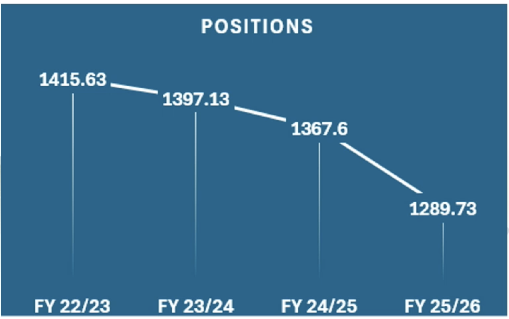
DHHS has taken numerous steps to reduce county spending. Since 2023, the department has deallocated 119 positions and consolidated some of its programs to operate more efficiently.
Decrease in DHHS allocated positions. | Screenshot
“These measures are designed to streamline operations, maximize available resources, and ensure that the department continues to meet the needs of the community while maintaining fiscal responsibility,” said Deputy Director of Finance Travis Green. “We’re doing everything possible to have the least impact on services to the community while doing these reductions.”
They’ve also gotten rid of landlines for staff with work cellphones and only use color ink for copies when absolutely necessary.
“We’ve learned that color copies cost six times more than black and white,” Beck said. “Obviously we are changing our settings on printers to ensure we use black and white whenever possible.”
Following DHHS’ presentation, the board thanked staff for their dedication and acknowledged the difficult times ahead as budget discussions continue.
“Thank you for bearing with us and helping to steer the ship through some unbelievably rough waters. That goes for everybody in this room,” Fourth District Supervisor Natalie Arroyo said to the room full of department heads and staff. “This is a day I sort of dreaded just because it’s such a hard thing to get through.”
Second District Supervisor and Board Chair Michelle Bushnell echoed Arroyo’s statement, acknowledging the “heightened anxiety” surrounding the federal funding cuts.
“The anguish that is happening around the cuts that are coming is real,” she said. “It’s also real in our community.”
The board received detailed informational reports from several other county departments and offices, including the Clerk-Recorder/Elections, Treasurer-Tax Collector, District Attorney, Humboldt County Library, Public Works, Auditor-Controller, Aviation and UC Cooperative Extension. The Planning and Building Department will present its report at Tuesday’s regular meeting.
On May 4, 2025, Humboldt County Sheriff’s Office patrol deputies executed search
warrants at residences located in the 2800 block of Park Street and the 2100 block of 13th Street in
Eureka. The warrants were issued following an extensive Problem Oriented Policing investigation
targeting suspected illegal firearms trafficking by two previously convicted felons, Stephen Wayne
Owens Jr., (age 45), and Gordon Dale Briggs Jr., (age 45).
Deputies successfully located both suspects without incident. During the execution of the search
warrants, authorities seized an un-serialized firearm, commonly known as a “ghost gun,” along with
ammunition, suspected methamphetamine, digital scales, and drug-related paraphernalia.
Gordon Dale Briggs Jr. was arrested and booked into the Humboldt County Correctional Facility on
charges including PC 29800(a)(1) (felon in possession of a firearm), PC 30305(a)(1) (felon in
possession of ammunition), PC 24610 (possession of an un-serialized firearm), HS 11370.1(a)
(possession of a controlled substance with a firearm), and PC 32310 (possession of a large-capacity
magazine).
Stephen Wayne Owens Jr. was also arrested and booked into the Humboldt County Correctional
Facility on charges including PC 29800 (felon in possession of a firearm), PC 24610 (possession of
an un-serialized firearm), PC 30305(a)(1) (felon in possession of ammunition), PC 32310(a)
(possession of a large-capacity magazine), PC 1203.2 (violation of probation), and HS 11395(b)
(possession of drug paraphernalia).
The Humboldt County Sheriff’s Office encourages anyone with information related to this case or
other criminal activity to contact the Sheriff’s Office at (707) 445-7251 or the Crime Tip Line at (707)
268-2539.
Press release from the Humboldt County Sheriff’s Office:
As warmer weather draws more residents and visitors to our local rivers, the Humboldt County
Sheriff’s Office is reminding the public of the serious dangers posed by fast-moving, cold rivers,
particularly the Trinity River.
Although air temperatures are rising, river conditions remain hazardous. Snowmelt and spring runoff
have made the Trinity River and other local waterways swift, high, and extremely cold. These waters
can be deceptively dangerous, even for experienced swimmers.
Even when it’s hot outside, the river is still very cold. The cold water can cause your muscles to seize
up, making it difficult or even impossible to swim. Just a few seconds in cold, fast-moving water can
lead to tragedy.
The Humboldt County Sheriff’s Office Boating Safety and Swift Water Rescue Team advises the
public to take the following precautions when recreating near or on the water:
Always wear a properly fitted U.S. Coast Guard-approved life jacket when boating,
kayaking, paddleboarding, or swimming.
Never leave children unattended near rivers or creeks. Always keep a close eye on kids
and make sure they are wearing life jackets.
Avoid alcohol and drugs when participating in water activities, as they impair judgment
and reaction time.
Do not underestimate the current. Even if you’re a strong swimmer, the power of moving
water can knock you off your feet and carry you downstream in seconds.
Stay informed about river conditions and obey all posted warning signs and closures.
Emergency services are often limited in remote river areas, and response times can be delayed.
Taking precautions ahead of time can save lives.
We urge everyone to prioritize safety and make smart choices around our waterways. Let’s work
together to prevent water-related accidents this season.
If President Donald Trump’s budget proposal gets implemented as written, experts say it could drastically increase the number of Americans out on the street. Photo by Larry Valenzuela, CalMatters/CatchLight Local
###
This story was originally published by CalMatters. Sign up for their newsletters.
###
On Friday President Trump released a budget blueprint for the next fiscal year that would take a chainsaw to social, environmental and education programs. Some of the sharpest cuts are directed at housing programs that are meant to serve the poor, housing insecure and unhoused.
In California, millions are served by these funds and state and local governments depend on them to operate affordable housing, rental assistance, homeless service, planning and legal programs.
In a letter to the U.S. Senate Appropriations Committee, the president’s budget director, Russel Vought, laid out $163 billion in annual spending cuts coupled with “unprecedented increases” in military and border security spending. The cuts, Vought wrote, are directed at areas of spending that the administration found to be “contrary to the needs of ordinary working Americans and tilted toward funding niche non-governmental organizations and institutions of higher education committed to radical gender and climate ideologies antithetical to the American way of life.”
That includes $33.5 billion in proposed cuts to the Housing and Urban Development department, a 44% reduction from current levels.
Presidential budget requests rarely reflect what Congress ultimately passes into law but are instead often viewed as something between an opening negotiating bid and a political vision board.
“You’d be looking at millions of people out on the street virtually overnight.” — Matt Schwartz, president, California Housing Partnership
Even so, the budget document makes for quite a vision — one that, if realized, would upend decades of federal housing policy and affect millions of lives.
The sheer breadth of the cuts provides an odd kind of solace to some affordable housing advocates.
“By following through on such a huge level with so many proposals that are going to gut assistance to low-income people across the country, including his own party’s states, he’s putting his own members of Congress in a very difficult place,” said Matt Schwartz, president of the California Housing Partnership, a nonprofit that advocates for more affordable housing. “The level of carnage that would be involved in doing these things is probably going to send some Republican senators running for the exits.”
A handful of powerful GOP senators have, indeed, already pushed back on the president’s proposal, though much of their ire was directed at what they saw as a lack of sufficient military spending.
The largest single cut in federal housing policy would target the Housing Choice Voucher program. Better known as Section 8, it’s currently administered by the federal government and helps low-income tenants with their rental payments. The White House is proposing shifting responsibility for the administration of that program, which it calls “dysfunctional,” to states, while cutting its funding in half.
It also proposes a two-year limit on how long a single person can receive help. That change is “completely out of touch with what people are facing in the housing market,” said Alex Visotzky, senior California policy fellow at the National Alliance to End Homelessness. With soaring rents outpacing people’s incomes, low-income tenants aren’t going to be able to magically earn enough money to start paying rent in two years, he said.
Additional cuts to four other housing voucher programs are meant to save $27 billion annually.
“You’d be looking at millions of people out on the street virtually overnight,” said Schwartz. “There’s no way states could maintain the same level of assistance.”
The administration proposes to save nearly $5 billion more by eliminating funds for local economic development grants, affordable housing developments and local initiatives to reduce regulatory barriers to new housing.
That latter program, a Biden-era initiative known as Pathways to Removing Obstacle Housing, was denounced in the administration’s budget write-up as a “woke” program that has pursued “radical racial, gender, and climate goals.”
The White House pointed specifically to a $6.7 million grant made to Los Angeles County to fund infrastructure planning, public transit-oriented housing and, as described in the county’s funding proposal, rezoning that would reverse the region’s “legacy of past systemic racism.”
Radical reshuffle of homelessness policy
The budget would slash federal homelessness funding by $532 million, while also radically changing the way those funds are distributed. The Continuum of Care program – the main way the federal government distributes funds to fight homelessness – would effectively end. It would be replaced by an Emergency Solutions Grant program.
The continuum program funds long-term solutions to homelessness, including permanent supportive housing, which is housing that comes with case management, counseling and other services for people with disabilities, mental illnesses, addictions or other struggles that mean they require extra help. Emergency Solutions Grants, on the other hand, fund more short-term solutions, such as homeless shelters, or short-term rental assistance for people who don’t need extra services.
That shift in funding would mean thousands of people would lose their supportive housing and end up back on the street, said Visotzky from the National Alliance to End Homelessness.
“This would be a significant shift away from the solution to homelessness, which is housing, towards shelter,” he said. “This budget is going to take away all the pathways to get out of shelter and into housing.”
Homeless veterans fared better. The budget proposes a $1.1 billion increase “for the President’s commitment to ending veterans’ homelessness.” Those funds would go to Veterans Affairs for rental assistance, case management and support services.
The budget also calls for the elimination of the U.S. Interagency Council on Homelessness, an agency tasked with coordinating homeless policy at the federal level, which the administration had already gutted.
End of “fair housing” enforcement as we know it
The White House also proposes zeroing out a grant program that funds nonprofit legal aid organizations that enforce national fair housing laws. According to the explanatory summary of the cuts published by the administration, these organizations advocate “against single family neighborhoods and promote radical equity policies.”
That characterization is strongly disputed by Caroline Peattie, executive director of the Fair Housing Advocates of Northern California. Federally recognized nonprofit fair housing groups processed 74% of all fair housing complaints submitted across the country in 2023, according to data compiled by the National Fair Housing Alliance. The remainder go to federal and state housing regulators.
A recent example: In 2022, Peattie’s organization received a complaint that a Nevada-based appraisal company was systematically undervaluing homes owned by Black and Latino Californians. The nonprofit investigated and submitted a complaint to the state. The California Civil Rights Department reached a settlement with the appraisal company in mid-April.
If all the cuts go into effect as proposed, Fair Housing Advocates of Northern California would lose roughly 75% of its funding, said Peattie.
“It’s just appalling,” she said. “When the fair housing organizations go away, then what?”
The across-the-board cuts come after months of legal battle between fair housing organizations and the administration. In February the Department of Government Efficiency, helmed by Elon Musk, abruptly terminated a key source of congressionally authorized funding for dozens of private fair housing organizations, including Fair Housing Advocates of Northern California. The groups sued. With that lawsuit pending, the funds, appropriated for fiscal year 2024, “are still in the ether,” said Peattie.
Last month, Congress passed a bill to keep government spending at current levels from the prior year, meaning that fiscal year 2025 spending is in a holding pattern for now.
“But as for fiscal year 2026, all bets are off,” said Peattie.
Assembly Speaker Robert Rivas during session at the state Capitol in Sacramento on April 29, 2024. Photo by Miguel Gutierrez Jr., CalMatters
###
This story was originally published by CalMatters. Sign up for their newsletters.
###
In December, Assembly Speaker Robert Rivas assigned his members an “urgent” task: Make California cheaper to live in.
“Californians are deeply anxious. They are anxious about our state’s cost of living,” he told his colleagues in the wake of an election where concerns about the economy were top of mind for voters. “We must chart a new path forward and renew the California dream by focusing on affordability.”
Five months later, the state Legislature has little to show for it.
Just last week, Rivas announced four new “select committees” tasked with pitching ideas to lower the cost of housing, fuel, child care and food, but they won’t meet until June, and Rivas did not specify when he expects legislation from the committees. Some of the lawmakers assigned to chair them say they want to develop “practical” solutions but did not articulate what those would be.
Similarly, Senate Democrats unveiled just three legislative proposals as their “opening salvo” to affordability last week, focusing on reducing energy costs, increasing housing supplies and boosting job training.
Economic justice advocates argue that Californians need immediate relief. Anya Svanoe, communications director for the Alliance of Californians for Community Empowerment, said renters are still feeling the pinch.
“Putting together a committee that comes together months from now that won’t even do anything until the following year does not seem to me that (lawmakers) are treating it with real urgency,” she said.
Democratic leaders told CalMatters good policies take time to develop. They noted that lawmakers had to shift their focus earlier this year to Los Angeles wildfire victims and counter Trump’s policies, and it took time to onboard freshman lawmakers.
“I have never been one to simply do something to get clicks or make headlines. I want substance and impact,” Senate Pro Tem Mike McGuire said in an interview. “My philosophy is: Do it right, not fast.”
Rivas spokesperson Nick Miller also said the select committees — essentially working groups established to tackle niche policies — will allow lawmakers to gather more public input and drill down on specific issues during the summer recess without feeling swamped by the regular legislative schedule.
Some analysts are skeptical that any proposals could actually make California more affordable, anyway. Garry South, a longtime Democratic strategist, said affordability is a problem “too large for legislative solution,” especially when compounded by Trump’s tariff policies.
“It’s political optics to some degree,” South said. “(The bills) all sound good on the surface, but I don’t think there’s any predictability that if any of them pass, or all pass, that all of a sudden we are going to be out of the housing crisis in California.”
Tackling the ‘biggest cost drivers’
Rivas said that the select committees will tackle the “biggest cost drivers for Californians.”
The committees will focus on four areas: Lowering the cost of child care for babies to 3 year-olds; making food more affordable and enrolling more people in CalFresh, the state’s food stamp program; exploring financing options for affordable housing; and examining the effectiveness of the state’s Low Carbon Fuel Standard, a clean energy incentive program that some argue could raise gas prices.
Assemblymember Lori Wilson, a Suisun City Democrat who chairs the Assembly Transportation Committee and will chair the select committee on fuel, said lawmakers have had a packed calendar.
“How could you even fit these types of conversations at the same time we are actively doing committees?” said Wilson, who sits on six different committees.
Lawmakers don’t need a new committee to develop solutions, because they are already introducing proposals in the current legislative session, said Mike Gatto, a former Los Angeles Democratic assemblymember who chaired the appropriations committee.
“Every single member of the Legislature has a pretty good understanding of what is causing this affordability problem in the state of California,” he said. “This information is out there.”
Select committees have traditionally been used to “give individual lawmakers who care about an issue … greater portfolio and greater exposure,” Gatto said. But he said they’re rarely effective.
“I don’t think too many veteran Capitol watchers can recall a select committee that produced significant results on an important issue,” he said.
But Miller pointed to last year’s select committee on retail theft last year, which produced laws to clamp down on organized shoplifting and toughen penalties on property thefts.
Proposals largely focused on housing
Optics or not, state Democrats’ affordability agenda appears clearer than a few months ago.
Led by Rivas, a strong ally of the YIMBY movement, Assembly Democrats are pressing for fewer regulations in exchange for quicker, more abundant new construction they argue would ultimately lower housing costs.
Lawmakers in early April approved a four-bill package to expedite building by streamlining the approval process for new housing and halting most changes to building standards for six years. One proposal would allow renters to take in people at risk of homelessness as long as their landlords agree.
Housing construction in a neighborhood in Elk Grove on July 8, 2022. Photo by Rahul Lal, CalMatters
“These bills will alter the trajectory of the housing crisis,” Rivas said in a statement.
Later that month, Rivas said he supported nine other “affordability” measures on housing, wage theft and broadband. One of them, introduced by Oakland Democrat Buffy Wicks, a major supporter of easing construction restrictions, would exempt most urban housing projects from the California Environmental Quality Act, making it all but impossible for environmentalists to sue to block developments.
It’s hard to know if any of those measures will lead to more housing construction, much less if they will make housing cheaper, said Bill Fulton, former director of planning and economic development for the city of San Diego and a fellow at the University of California-Berkeley Terner Center for Housing Innovation.
“In spite of the fact that all those bills have passed (in past years), we have not seen overall housing production increase very much or overall housing affordability go down very much,” Fulton said.
“The Legislature passed lots and lots and lots and lots of laws … without actually doing a careful analysis of what’s working and what’s not, and they continue to pass more laws.”
Fulton said other factors discouraging building in California include the high cost of labor and building materials and high interest rates, which are not addressed by the current raft of housing bills.
Svanoe, who champions tenant protections, said state lawmakers are streamlining housing development while doing little to make rent affordable. She supports Assembly Bill 1157, a progressive proposal to lower the cap on rent increases. Faced with pressure from YIMBY-aligned Democrats, the measure is now delayed until next year.
“There’s no room to give (on) any rent increase at this point,” Svanoe said. “It’d be the difference between someone staying in their home and someone becoming homeless.”
The housing measure included in the Senate Democrats’ affordability package is much more skeptical of new construction. While Sen. Aisha Wahab’s Senate Bill 681 would streamline some development, it would also restrict landlords from charging extra fees and crack down on homeowners association fees.
“We’re reinforcing the state’s housing production goals, but not at the expense of the Californians who are barely hanging on,” Wahab, a Fremont Democrat who chairs the Senate Housing Committee, said in the legislative analysis.
Bill “Bud”
Sargent would approve of this escapade for the summer of 2025:
Traveling across the country in our Sprinter van to see games in all
30 Major League Baseball parks in 100 days. Bud was a lifelong
baseball fan and a diehard San Francisco Giants fan. His dying wish
was for his cremated ashes to be put into a Jack Daniels bottle and
tossed into McCovey Cove near Oracle Park.
We met Bud’s
granddaughter, Anna Sargent, at a Giants game during this first week
of the trip. “Then with every splash home run, we can say
‘grandpa’s got it,’ ” Anna said. “We’ve done the first
two things but we haven’t thrown him in McCovey Cove yet.” More
from Anna later.
The purpose of the
trip is to assess each MLB ballpark for LoCo faithful, focusing on
game atmosphere, ballpark cuisine and club hospitality. Helpful tips
will also be provided regarding parking and rules for each park.
Consider it an insider’s guide to each ballpark. Rankings for the
areas of game atmosphere, ballpark cuisine and club hospitality will
at first be either positive, neutral or negative. After all the parks
are visited, these rankings will be converted to a score on a scale
of 100, making 300 a perfect score.
Game atmosphere
rankings will be based on things the club does to add some sizzle to
the game-day experience and how much the fans are invested. Ballpark
cuisine rankings will be based on quality and diversity of food that
is offered. Club hospitality rankings will be based on how well the
team’s treat us. Is a correspondent for LoCo brushed off as an
insignificant small market ne’er-do-well or do the team’s
recognize us as a legitimate source for information?
The first week of
the trip started with a flourish – four baseball games in five
days, starting in West Sacramento, then traveling to San Francisco,
Los Angeles and San Diego.
Game #1: White
Sox versus Athletics at Sutter Health Park, April 26
By Major League
Baseball standards, Sutter Health Park is tiny with 12,000 seats and
a 14,000 capacity if you count the grassy lawn area in right field.
This AAA Park, home to the Sacramento River Cats, will double as home
for the Athletics for at least the next three years while the A’s
new stadium in Las Vegas is built.
Guest services rep
John Cobb has high hopes for the Athletics stint in West Sacramento.
“If we can prove to the baseball commissioner that we’re
Major-League ready, we can get one of the two expansion teams that
are planned for the future,” Cobb said. “If not this park, then
one built near the rail yards.”
Baseball
Commissioner Rob Manifred has said he would like to see the expansion
process underway and the cities selected before his term as
commissioner expires in January of 2029. Sacramento is listed as one
of many candidates. It is expected that one expansion team will be
from the eastern time zone and another from the mountain or western
time zone.
Sutter Health Park
has most of its seating on one level, with a second level for media
and luxury suites. While it is an excellent AAA venue, the only
realistic chance Sacramento has to bring in an expansion franchise
would be to build a new park.
Game atmosphere:
Neutral
The Athletics are
under no illusion that Sutter Health Park is a Major League baseball
stadium. So they pump up the volume on promotions and giveaways to
help make up the difference. Athletics basketball jerseys were given
away at this game. In three different innings, t-shirts were thrown
and bazooka’ed into the crowd. Fireworks follow each Friday and
Saturday game. Wet-nosed Wednesdays allow pet owners to bring their
dogs to sit in the outfield lawn area. Between-inning action included
plush baseballs tossed into the stands during the Broadcaster Ball
Toss and a Big Head race featuring mascots of A’s Hall of Famers
Dennis Eckersley, Rollie Fingers and Rickey Henderson.
The crowd enthusiasm
at this game was dampened by a fast start by the White Sox who scored
four runs in the first inning with a home run and three doubles, and
a steady rain in the middle innings. There were lots of families in
the outfield lawn area. And, while the listed prices for lawn tickets
is $50, it’s easy to get them half off with various promotional
offers. There is a kid’s play zone in the outfield with a wiffle
ball field and a Tower Bridge replica.
Ballpark cuisine:
Negative
There’s not a lot
offered besides the typical ballpark fare of hot dogs, hamburgers,
pizza, sausages and chicken tenders. There was a Golden State Slider
& Cider food truck that looked promising, offering generous
proportions on a trio of sliders with a choice of pulled pork or
brisket. Kevin and Keri Barber were our food tasters for the sliders.
“The meat is okay but the slider itself is underwhelming,” Kevin
Barber said. “They are lukewarm which is surprising since they
prepared it while we waited for 10 minutes. The BBQ sauce is very
sweet. Too sweet.” Guest services rep Cobb earlier recommended the
Chicken Strips with garlic fries as the best food. It turns out he
was right! Best line of the day came from a vendor wandering through
the lawn area: “Churros. Beer. Free delivery.”
Club hospitality:
Positive
A’s provided us
with parking in the media area and visitor passes that got us into
the stadium, but no actual seats.
Game details:
White Sox win 10-3. Attendance 8,832. Time of game: 2:30.
Helpful tips:
There are several parking lots adjacent to the stadium with costs
ranging from $30 to $40. The team provides shuttle golf carts from
the parking lots to the stadium. Only clear bags are allowed to bring
into the stadium. Unopened soft-sided water bottles are allowed.
You don’t see
that every day: Leather couches in the women’s restroom.
Game #2: Rangers
versus Giants at Oracle Park, April 27
Oracle Park has gone
through a few name transitions over the years, and when it opened as
PacBell Park in 2000, it was a dream come true for many Giants fans.
“I was waiting for Oracle to be built my entire life after
suffering 40 years at the concrete circle that was Candlestick Park,”
said Jeff Frediani, a lifelong Giants fan. “The views, the sight
lines at Oracle are unbelievable. It was built for baseball. And
you’re closer to the field than you ever were at Candlestick.”
Game atmosphere:
Positive
Even though we
arrived at the game 90 minutes before the first pitch, there was
already a lot going on at Oracle. One reason was it was youth
baseball/softball day and a lot of kids and their parents were
already roaming the stands, especially the outfield area with the
giant Coke bottle slides and the Mini Ballpark. It will be tough to
beat this family-friendly area where kids have two choices for
360-degree slides – The Guzzler for kids at least 42” high and
The Twist Off for kids at least 36” high. The Mini Ballpark is for
kids under 36” high. There is also a replica of a cable car for
pictures or for kids to play in. Something for kids of all sizes!
Adding to the
commotion was a promotion by The Mercury News in the Fan Zone. The
newspaper was giving away a choice of a Giants sweatshirt, blanket or
cooler bag with every sign-up for 2-months of digital content for
$15. There was a long line of takers.
Youth
baseball/softball day was also celebrated in the bottom of the third
when the Giants gave the public address microphone to one of the
youth baseball kids who announced each batter for the Giants as they
came to the plate. It’s this kind of personal touch that has
endeared the Giants to its fans in the Bay Area and beyond.
“The Giants fans
are among the best in baseball,” said Anna Sargent. “I may be
biased because I grew up within 90 miles of Oracle, and I’ve always
been within a 2-hour radius of the park as an adult. This is my team,
my people.” While Anna has been hesitant to toss her grandpa’s
bottle of ashes into McCovey Cove, she does have a next-step plan.
“I’m going to surprise my dad on Father’s Day and put a brick
with grandpa’s name using the Giants Anniversary brick program.”
Fans can engrave a special message on a brick (priced at $399 or
$649) along the scenic Bay Trail in China Basin Park, just steps from
the ballpark.
This game was sold
out and the Giants fans were raucous throughout, culminating with a
crazy finish and an exhausted Heliot Ramos sprawled at home plate.
(See details below under “You don’t see that every day.”)
Ballpark cuisine:
Positive
Three words vault
the Giants ballpark cuisine into the upper echelon: Crazy Crab’z
Sandwich. It’s not cheap but it’s fantastic. “The Crazy Crab’z
sandwich is 100 percent worth it,” said Sargent. “I don’t even
look at the price. I get It every time I come to a game.” For those
who do look at the price – it’s $25. Other notable offerings are
a clam chowder sourdough bread bowl, crab Louie salad, Orlando’s
Cha Cha Bowl (Jamaican jerk chicken with rice and beans), Rah-Rah
Ramen, and the Ghirardelli Chocolate Hot Fudge Sundae. According to
Frediani, while delicious, the problem with the Ghirardelli sundaes
is there is a long line to wait to order it, then another long wait
to get it.
Club hospitality:
Positive
Giants provided
tickets four rows from the field, halfway between third base and the
left field fence. There is no parking at Oracle so parking was not
provided.
Game details:
Giants win 3-2. Attendance 40, 118 (sold out). Time of game: 2:37
Helpful tips:
There are a couple of affordable parking options for Oracle. The one
we chose was to park at the South San Francisco CalTrain station for
$5.50. Tickets on the train are $3.75 each way with only a one-block
walk to Oracle Park. Another option is to park for free at the Daly
City BART Station and take BART to the game. This option will take
long as it is about a mile walk to the game from the BART station. …
Backpacks – even clear ones – are not allowed at the park.
You don’t see
that every day: A walk-off little league home run. Heliot Ramos
led off the bottom of the 9th inning with the score tied
2-2. He hit a dribbler toward third that the pitcher fielded, then
tossed down the right field line. Ramos ran to second, then slowed
down. Third-base coach Matt Williams was waving him to keep coming.
After a quick glance over his shoulder, Ramos started running again
toward third base. He dove safely into third and the ball ricocheted
into left field. Ramos got up and stumbled toward home plate where
his remaining available energy got him just to the point of
collapsing on home plate for the game-winning run.
Dodger stadium is
the third oldest stadium in Major League Baseball, behind Fenway Park
and Wrigley Field. It opened in 1962 and, thanks to a great design,
has held up well in the 63 years since. In 2021 the team created a
Centerfield Plaza around the two outfield Pavilion seating areas. It
includes almost two acres of food offerings, entertainment and kid
areas, and retail locations. “The stadium has ambiance and beauty –
an open view in centerfield of the greenery and the mountains,”
said Richard Mathews, a lifelong Dodgers fan who has been going to
games since 1963. “The Dodgers have a tradition of excellence in
Los Angeles. I like what they stand for: a tradition of winning and
they embrace diversity. They draw fans from across the spectrum of
the city of Los Angeles.”
Game atmosphere:
Positive
An hour before the
game things were upbeat and high energy. It was Women’s Night and
the team celebrated with a woman-led live band (Zoe Kilgren Band)
performing in the Centerfield Plaza. The Dodgers kept the Women’s
Night Theme going with national anthem performed by a female electric
guitarist, and the first pitch thrown out by a woman. It was hard to
find a fan that did not have on a Dodgers jersey or Dodger
sweatshirt. Dodger fans have a reputation for leaving the game early
to beat the freeway traffic but this game did not follow that
pattern. Yes, some did leave in the 7th inning, but
despite it being a blowout Dodger victory, the majority stayed until
the last out. … The only game atmosphere criticism would be
regarding the main scoreboard. Somebody tried to fit the entire
Baseball Encyclopedia on one screen, making it difficult to even
figure out where to look to see the score. … There are multiple
play areas for the kids in both the outfield plaza and the upper
reserved area. … The Dodgers comped more than 1,000 charter school
students to the game. … There’s a lot of stairs to navigate
between buying your Hot Chicken Mac-n-Cheese at field level and
finding your seats in the Upper Reserved section.
Ballpark cuisine:
Positive
The influx of star
Japanese players to the Dodgers roster has had a side effect of
bringing Japanese cuisine options to the Dodgers cuisine menu to
satisfy the many Japanese fans that now come to the games. The star
offering is Takoyaki – piping hot umami-filled octopus fritters
with a variety of toppings. They are commonly referred to as Octopus
Balls. Aaron Henkin said his wife tried the Octopus Balls earlier in
the season when they had a giveaway promotion. She didn’t like it,
but Aaron ordered them anyway because he questioned her palate. He
was happy he did. “It’s really good,” he said. “The filling
is good. Not too creamy. The texture of the breading is spongy and
nice. The Bonito flakes add a tangy sweetness. It’s like a really
moist hushpuppy. I would definitely get this again.” Two other fan
favorites are the Hot Chicken Mac-n-Cheese and a Cheet-O-Lote. “The
chicken on the Mac-n-Cheese is chicken breast with a hot, spicy
breading, and it’s chopped into bite-size pieces,” said Ginger
Gonzales, one of the stadium food workers. “It’s topped with cole
slaw. The Cheet-O-Lote is a grilled street corn brushed with a cream
mixture, then rolled in hot Cheeto dust.” Then it’s drizzled with
Sriracha mayonnaise. Of course, the king of ballpark cuisine at
Dodger Stadium is the Dodger dog. It’s offered throughout the
stadium, while the specialty items are only sold on the field level
in one location. But the Dodger dog is not much different from any
hot dog sold in any other stadium. I asked longtime Dodger fan
Richard Mathews after he took a couple of bites of his Dodger dog:
“Is it as good as you remember it?” His reply: “It’s the same
as I remember it. But it’s tradition.”
Club hospitality:
Negative
The Dodgers supplied
no tickets and no parking. When LoCo editor Hank Sims requested media
parking from the Dodgers, the response was “Unfortunately, this is
not something we can accommodate.” Well, they could
accommodate but chose not to. Fortunately for us, Cal Poly Humboldt
women’s assistant basketball coach Guillermo Blas Jr. came through
with tickets in the Upper Reserved section, thanks to his sister who
works with the Dodgers Foundation.
Game details:
Dodgers win 15-2. Attendance: 46,502. Time of game: 2:48
Helpful tips:
There is free alternative parking to the $35 to $60 that Dodger
stadium charges. Take the Academy Road exit off the 110 freeway.
Signs will point you toward the police academy. There is a long
stretch of free street-side curb parking that ends right before the
entrance to Dodger Stadium. Mostly RVs and Sprinter vans (which are
charged double for parking at Dodger Stadium) use this option. It’s
an extra 1000-feet of walking but the price is right. Another option
is to park at Union Station downtown for $18 and take the free
shuttle to the game. … Dodgers allow unopened plastic water bottles
to be brought into the stadium. There is a clear-bag policy with the
exception of purses. … There is no tailgating allowed in the
parking lot.
You don’t see
that every day: Each team used a position player instead of a
pitcher to finish the game on the mound (Padres with Javier Sanoja,
Dodgers with Kike Hernandez). The Dodgers were one of three teams to
score 15 runs that day (Yankees and Rangers were the others). Each
team’s left fielder was 9th in the batting order.
Petco Park opened in
2004 but it still seems new. The field level walkways shine. “I
love watching games here,” said Michael Shoen. “The fans get
pumped. It certainly helps that we’re winning, but the Padres are
the only pro team left in San Diego so the fans get pumped.” Petco,
like many ballparks built in the last 25 years, built a park that
fits in so well with its downtown surroundings that it seems like it
has always been there. There is a refreshing waterfall at the main
entrance.
Game atmosphere:
Positive
It was Bark at the
Park Day where dog owners buy a special ticket to sit in the
Gallagher Square section with their canine and participate in a
pre-game dog walk along the outfield fence inside the stadium. What
else would you expect from Petco? There are six Bark at the Park days
in 2025 and they are all already sold out. We saw many show-worthy
dogs in attendance and hundreds of dogs altogether. … Gallagher
Square is a family-oriented area beyond the outfield fence where fans
can still peak in the stadium through the open centerfield area.
There is a fine grassy lawn area, its own concession area and a kids
play area. … The Padres fans were very engaged in the action. This
was the first game on our trip where there was a sizable number of
fans from the opposing team (the Giants), but every time the Giants
fans would start a “Let’s Go Giants” chant – it was quickly
drowned out with a “Let’s Go Padres” chant. … The game-day
atmosphere may have been best summed up by Padres rep Michael Weber:
“Any day at the ballpark is better than a day anywhere else.”
…The scoreboard features just the right amount of information,
including an easy-to-find pitch count that switches over to pitch
type and pitch speed after every pitch. … The park elevator has an
elevator attendant in case you need help figuring out which of the
two options to pick (and probably to keep the kids from turning it
into a play area).
Ballpark Cuisine:
Positive
The Padres are so
proud of their ballpark cuisine that they hand out a Petco Park Food
Guide to everyone in attendance. It lists every food offering and
where you can find it in the stadium. Many of the food vendors are
from area restaurants offering their specialty items. The top pick is
Seaside Market Tri Tip Nachos. “You can’t go wrong with the
Seaside Market Tri Tip Nachos,” said Craig Degraff. “They are
super good. People will travel 25 miles to Cardiff just to get their
tri tip.” The marinated burgundy pepper tri tip is laid on top of a
bed of nachos covered in Diego Queso. Then it’s covered with BBQ
sauce, sour cream and green onions. Another favorite is a Baja
Lobster Roll by Pacific Grab & Go. It’s a long roll with
lobster salad with an option of a hot link stuffed inside. “I had
it the last time I was at a game,” said jose Batallia. “It was
very good. But it needed a little something. So this time I’m
trying it with the hot link. It’s expensive but it was worth me
coming to get it again.” The lobster roll is $39 or $37 with the
hot link. The Kona sliders on the fifth floor of the stadium are also
very good with three options from which to choose: Bourbon Bacon Blue
Sliders, Pretzel Beer Cheese Sliders or Social Sliders – all on
Hawaiian rolls. Plus there are bacon-wrapped hot dogs, gyro bowls,
acai bowls, boba tea, carnitas fries and Negihama sushi. Even the
regular cheeseburgers are gourmet. Did I mention there are even mini
donuts and a local craft beer section?
Team Hospitality:
Positive
The Padres provided
two field level tickets to the game and a parking pass in the
tailgate parking lot.
Game details:
Padres win 5-3. Attendance: 37,698. Time of Game: 2:34.
Helpful tips:
Parking is from $35 to $45 in nearby parking lots. … Only extremely
small purses are allowed into the park – no bigger than 5” by 7”.
All other bags must be clear. … They do allow factory sealed
bottled water and outside food as long as it is wrapped or bagged.
You don’t see
that every day: In the bottom of the third inning, Elias Diaz led
off with a line shot to left. A fan in the front row wearing a Giants
t-shirt reached his glove over the fence but the ball caromed off his
wrist. After a lengthy crew chief review, it was determined it wasn’t
fan interference. From the crew chief: “The fan stuck his glove
over the field of play. However, the ball struck him in the wrist
which was beyond the field of play. It is a home run.”
Play along
guessing game
Answer these five
questions correctly and be eligible in August for a prize pack worth
at least $19! Put your guess in the comments.
#1: How many games
will the home team win?
Less than 15.
15.
More than 15.
#2: Will we see at
least one complete game during our 30 games?
Yes.
No.
#3: What will be the
average attendance at the 30 games?
Under 29,000.
29,000 to 31,000.
More than 31,000
#4: What will be the
average length of each game?
Less than 2
hours and 35 minutes.
2:35 to 2:40.
More than 2 hours and 40
minutes
#5: License plates:
At what point in the trip will we complete the quest to see all 50
states and at least five Canadian provinces on vehicle license plates
as we drive?
First 75 days.
Last 25 days.
It won’t happen.
###
Tom Trepiak is the former sports information director at Humboldt State and a member of the Cal Poly Humboldt Athletics Hall of Fame.


.jpg)


