
They’ve Set a Date for the Eureka-to-Arcata Bike Trail’s Grand Opening Party
LoCO Staff / Thursday, April 10, 2025 @ 9:30 a.m. / Community

Coming this summer: Bike it, walk it, rollerblade it.
Press release from the Redwood Community Action Agency:
CELEBRATION TIME – HUMBOLDT BAY TRAIL SOUTH OPENING – SAVE THE DATE
The eagerly awaited opening of the Humboldt Bay Trail segment connecting the cities of Eureka and Arcata will be celebrated on Saturday, June 28. This segment of the Humboldt Bay Trail, also part of the Great Redwood Trail, will be celebrated through a series of activities throughout the day, culminating with a trail party at the Adorni Center, 1011 Waterfront Drive in Eureka from 3:00 to 6:00 PM. The party will include music, food trucks, trail partner tabling and brief comments by invited speakers recognizing the decades of work to make the trail possible. Following the recognition program, dance to the musical stylings of Pandemonium Jones. Refreshments will be available. Individuals or organizations interested in being a part of this day should contact Carol Vander Meer at: cvandermeer@rcaa.org. More details about the event will be available at our website: tinyurl.com/trailparty
Organizers & supporters of the Humboldt Bay Trail Grand Opening Celebration include the Coalition for Responsible Transportation Priorities (CRTP), Great Redwood Trail Agency, Redwood Community Action Agency (RCAA), Humboldt Trails Council, Ink People Center for the Arts, Humboldt County Association of Governments (HCAOG), County of Humboldt, City of Eureka, City of Arcata, Bike Month Humboldt Coalition, Friends of the Eel River, Humboldt Waterkeeper, Environmental Protection Information Center (EPIC), Humboldt Bay Bicycle Commuters Association, Redwood Coast Energy Authority, and Mir de Silva.
BOOKED
Today: 5 felonies, 9 misdemeanors, 0 infractions
JUDGED
Humboldt County Superior Court Calendar: Today
CHP REPORTS
3800 Mm96 E Sis 38.00 (YK office): Trfc Collision-No Inj
ELSEWHERE
County of Humboldt Meetings: MIESC (McKinleyville Incorporation Exploration Subcommittee) Special Meeting Agenda
County of Humboldt Meetings: MIESC (McKinleyville Incorporation Exploration Subcommittee) Meeting Agenda
County of Humboldt Meetings: MIESC (McKinleyville Incorporation Exploration Subcommittee) Meeting Agenda
County of Humboldt Meetings: MIESC (McKinleyville Incorporation Exploration Subcommittee) Special Meeting Agenda
Trump Targets California Climate Laws in New Executive Order
Alejandro Lazo / Thursday, April 10, 2025 @ 7:03 a.m. / Sacramento
Chevron’s refinery in Richmond on Feb. 21, 2024. Trump in his order says state policies like California’s cap and trade program discriminate against oil companies and raise the cost of energy. Photo by Loren Elliott for CalMatters.
###
This story was originally published by CalMatters. Sign up for their newsletters.
###
President Donald Trump has issued an order that takes aim at state and local climate change laws and policies, including California’s landmark market program for reducing greenhouse gases.
Trump’s executive order directs U.S. Attorney General Pam Bondi to identify state and local acts that may be unconstitutional or preempted by federal law. Within 60 days, the attorney general must report back to the president with findings and recommendations for action.
Trump’s order names California’s cap and trade program, a market-based system created in 2012 that is considered one of the state’s key policies for combating climate change. The program sets limits on greenhouse gas emissions and allows companies to buy and sell credits. Twelve other states have similar trade programs for cutting greenhouse gases.
“California, for example, punishes carbon use by adopting impossible caps on the amount of carbon businesses may use, all but forcing businesses to pay large sums to ‘trade’ carbon credits to meet California’s radical requirements,” Trump’s order says.
The order comes as the Trump administration moves to boost domestic oil and gas production while sidelining efforts to develop wind and solar.
Trump’s order says states have mounted “illegitimate impediments” to domestic energy production for oil, natural gas, nuclear power and other energy sources. Notably, the order derisively placed the term “climate change” in quotation marks.
Some legal experts called the order an overreach, disputing the president’s claims that states are exceeding their authority or that their climate programs are unconstitutional.
“The implication that the attorney general can just go out and declare this state law is unconstitutional and that therefore it’s no longer a valid law — that is the big problem with this,” said Margaret A. Coulter, a senior climate attorney with the Center for Biological Diversity. “It’s more of an intimidation tactic.”
Amy Turner, director of the Cities Climate Law Initiative at the Sabin Center for Climate Change Law at Columbia Law School, said the Constitution’s 10th Amendment grants states the authority to set their own rules in areas where the federal government has not acted. “In other words, the federal government cannot simply grab powers because it wants to; doing so would in no uncertain terms represent a constitutional crisis,” Turner wrote.
Still, they say the order could have an overarching effect on the states. Turner wrote that Trump’s order “does not directly challenge, prohibit, argue preempted, or enjoin any state or local law. But it is likely a forerunner to litigation, lawmaking, or the withholding of federal funds.” This, she wrote, will have “a significant chilling effect on local climate policy innovation.”
California Attorney General Rob Bonta did not immediately return CalMatters’ calls seeking reaction to the Trump order.
The first Trump administration sued the state of California challenging its cap-and-trade program, which is linked to a program in Canada, on the grounds that the state was entering into an international treaty. Trump lost that lawsuit.
Trump said state climate policies and laws “unduly discriminate” against fossil fuel companies and “impose arbitrary and excessive fines without legitimate justification,” which raises energy costs for Americans.
“These State laws and policies are fundamentally irreconcilable with my Administration’s objective to unleash American energy. They should not stand,” it says.
Trump also singled out laws in New York and Vermont that created climate funds requiring fossil fuel companies to contribute to a fund for climate adaptation. The goal is to cover the rising costs of extreme weather events.
In addition, the order targets civil actions against fossil fuel companies. California is leading efforts to make fossil fuel giants pay billions of dollars for the climate damage they have long denied.
Trump said these programs “extort” money from oil companies.
The oil industry has been pushing the Trump administration to take a more aggressive legal stance against these state climate accountability efforts. Industry groups are encouraging the Justice Department to either back their lawsuits or initiate federal challenges of its own against states like New York and Vermont, The Wall Street Journal has reported.
California is considering similar legislation. A bill introduced by Sen. Caroline Menjivar, a Democrat from Van Nuys, would require companies to pay for the damage that greenhouse gas emissions have caused in California since 1990.
OBITUARY: Robert Bradley Crouch, 1968-2025
LoCO Staff / Thursday, April 10, 2025 @ 6:56 a.m. / Obits

Robert, Robbie, Rob, “Papa” (never Bob) Bradley Crouch was born on Tuesday, June 28, 1968. Robert came out screaming, so excited to be the annoying little brother of Steve. Crashing down the hills of San Diego on his Big Wheel and getting lost while camping in Mammoth with brother and Dad. Robert attended Mt. Carmel High School, where he loved being on the football team as player #44 and MVP throughout his high school career, later moving to Humboldt to pursue an engineering degree at Humboldt State University.
Robert was a wonderful, creative chef, who worked at several local establishments such as Sunset Restaurant, Cher Ae Heights, and Scotia Inn. While working at the Scotia Inn, Robert met Jean Marie and joined a family of teenagers, Lyndsay, Michael and Will. Welcoming his first grandchild, Gabriella, followed by Liam, Kaia and Lyla forever being, “Papa.” Nearing retirement, Robert worked at Costco, where he had many visitors who knew him well and made an effort to stop by for a short visit. Robert made many lifelong friendships and connections with those around him.
Robert met his love, Donna, who also attended Mt. Carmel High School in San Diego, meeting for the first time thirty years later, finding each other in old yearbooks, becoming his “spicy freshman.” The love shared between the two of them blossomed and they started their adventures together, braving the world and creating beautiful experiences for themselves and family. Taking walks in the paradise of Humboldt, Wordle mornings, beach adventures with their super pooper dog Cooper, evening puzzles, enjoying time in their lovely home listening to the rain on the roof, and building stairs in their backyard forest to overlook “Lake Sometimes.” Together, each year Rob and Donna thoughtfully curated an annual Christmas Treasure Hunt on Christmas Day, filled with mysteries, fun clues and playful challenges for his daughter and granddaughters. Christmas caroling while bringing treats to friends, chasing (at least trying to) orbit toys through Manila Park, wooden airplane races at Redwood Bowl, dressing up as pirates and crabs and digging up treasure on the beach, and finding rubber duckies at Sequoia Park are just a glimpse into the magic that Papa created.
Robert, our lucky duck, passed unexpectedly from us on Friday, February 14, 2025 and is missed lovingly everyday. Robert’s love is continued by many who adore him, including his parents Jimmie and Elizabeth and Beverly and Mel as well as other beloved family members in California, Arizona, Utah and many local friends and found family. Papa is remembered by PB&J sandwiches with milk, his air guitar skills, being a Wii disc golf master, trying a new hot sauce, and through acts of kindness and love.4
An intimate ceremony with family is planned and a Celebration of Life ceremony is in planning and those who would like to attend can reach out to Gabriella Lynn on Facebook for details.
###
The obituary above was submitted on behalf of Robert Crouch’s loved ones. The Lost Coast Outpost runs obituaries of Humboldt County residents at no charge. See guidelines here. Email news@lostcoastoutpost.com.
Farm Bureaus in Russian River Counties Issue Plea to President Trump to Keep the Potter Valley Dams in Place
LoCO Staff / Wednesday, April 9, 2025 @ 4 p.m. / Environment

Scott Dam, with Lake Pillsbury behind it. Photo: PG&E.
PREVIOUSLY:
###
About a month ago, the Lake County Board of Supervisors begged President Donald Trump to put a halt to the deal to remove the two antiquated hydropower dams way up near the headwaters of the Middle Fork main stem of the Eel. That deal was reached in mid-February, after years of negotiations.
PG&E doesn’t want the dams anymore. It plans to petition the Federal Energy Regulatory Commission to allow them to be removed, in a process that would mirror the historic undamming of the Klamath.
But Lake County wanted to throw some sand in the gears, and now that body is joined by the local chapters of the Farm Bureau in Lake, Mendocino, Sonoma and Marin counties. Last week, they sent a letter to President Trump, who has made speeches about the folly of allowing the water in California rivers to return to the sea, and in that letter they petition the president to order FERC to keep the dams in place.
Here’s the letter from those Farm Bureaux.
Here’s a press release from Friends of the Eel:
Turning a blind eye to serious safety and reliability concerns, as well as questioning a private company’s business decision, the Farm Bureaus of Marin, Sonoma, Lake, and Mendocino Counties have asked the Trump administration to halt or delay the removal of Scott and Cape Horn Dams.
The dams comprise the Potter Valley Project on the upper Eel River. Dam owner Pacific Gas and Electric (PG&E) must surrender its current federal license to operate the dams, and intends to remove them starting in 2028. A separate agreement announced this February by Eel and Russian River interests proposes construction of a new, low-impact facility to maintain a reliable water supply to the Russian River through wet-season diversions from the Eel.
In an April 5 letter, the agriculture organizations argue that, instead, the federal Bureau of Reclamation should acquire the dams from PG&E and continue to operate them for the benefit of Russian River water users. Alternatively, they propose Eel River dam removal be delayed until Coyote Dam, on the upper Russian River east of Ukiah, is raised to provide additional storage in the Lake Mendocino reservoir.
PG&E has been clear that it does not make economic sense to operate the Potter Valley Project. In 2021 when the project’s transformer failed, PG&E ultimately decided not to replace it. At the time, the company projected it would take 18-24 months, at a cost of $5-10 million. Without a transformer, the project produces no electricity. But with renewables surging, especially cheap solar and batteries, PG&E doesn’t need the expensive electricity the Eel River dams used to make. Even when the project was producing power, PG&E estimated that operating the project cost more than 20 times its revenue.
Simply put, Scott and Cape Horn dams have come to the end of their useful life. Scott Dam, built in 1922, has accumulated so much sediment that its operations are restricted and dam failure is an ever-increasing threat. If the water level in the Lake Pillsbury reservoir falls too low or too quickly, PG&E engineers warn, the accumulated sediments near the base of the dam will fall down and clog the only low-level water outlet on Scott Dam. That would end diversions entirely.
However, it is Scott Dam’s vulnerability to seismic damage that is the real headline. Over the last 20 years, the US Geological Survey has mapped the Bartlett Springs Fault. We now know what Scott Dam’s builders did not: that the dam sits nearly atop the fault, near the middle of its more than hundred-mile length. We know that the fault can create earthquakes of magnitude 7 and greater.
And we know that in 2023, within a week of PG&E receiving an assessment of Scott Dam’s seismic vulnerability, the utility lowered the radial gates atop the dam. We also know that the California Division of Safety of Dams told PG&E they can’t raise those gates again without permission. These gates were built to compensate for volume lost to sedimentation; lowering them reduces reservoir capacity by about 20,000 acre feet. Between seismic risks, sediment problems, and the need to avoid harming Eel River fisheries, diversions from the Project have become at best unreliable.
Not if, but when Scott Dam’s only low-level water outlet is clogged, or an earthquake topples the whole thing, the diversion to the Russian River will end. The best way for Russian River interests to secure a reliable diversion is not to fight Eel River dam removal, but to remove the antiquated dams now and build a modern, run-of-the-river diversion structure. Of course, they must also continue working toward self-sufficiency within their own watershed.
The critically imperiled salmon and especially steelhead of the Upper Eel River need dam removal as soon as possible. And the commercial fishing industry desperately needs relief as they look toward a potential third disastrous year of fishery closure. Against piles of evidence and analysis, the farm bureaus claim instead there’s some magically cheap and effective way to provide fish passage over Scott Dam. There is not.
The farm bureau proposal appears to align with the federal administration’s ambitions of rolling regulations back to the 1950s. Back then PG&E and the Russian River took as much of the Eel’s flows as they wanted whenever they wanted, driving Eel River salmon and steelhead toward extinction. It would also be deeply unfair to expect PG&E’s already-burdened ratepayers to carry the costs of keeping the Eel River dams operating for the benefit of wealthy landowners and perpetuating the injustice to farmers, towns, fishermen, and Tribes in the Eel River. That is the essence of this predatory proposal: powerful entities resisting change to unsustainable systems because they benefit from the status quo.
Eureka’s Asian Restaurant Kingpin Hates Owning Restaurants, But He’s About to Open Another One Anyway
Dezmond Remington / Wednesday, April 9, 2025 @ 3:36 p.m. / Food , People of Humboldt

Joe Tan prepares a plate of sushi at Rooftop. By Dezmond Remington.
Joe Tan met me at the door clad in a dark chef’s uniform and a black Giants ball cap and asked if I wanted a glass of water. We sat outside and the sky spat rain and smiled sun at us off and on for about half an hour before retiring to a reasonable gray. It cast no light over Eureka, which we had a fantastic view of from Rooftop Sushi’s patio.
There is nothing extraneous on that patio, nothing to distract diners from the food laid out in front of them or of Old Town stretching away from them. That is the way Tan likes it: Clean. Perfect. Precise. The way Tan — the owner of Rooftop Sushi, Curry Leaf and the soon-to-be-opened Kokoro Ramen — makes his food is the same.
It would not be much hyperbole to call Tan Humboldt’s Asian restaurant kingpin. Besides those three, he used to own Nori in Arcata and moved to Eureka to work at Bayfront about 10 years ago.
Despite the expansive portfolio, Tan does not at all see himself as a restaurateur. He is a chef trapped in the Iron Maiden of business management.
“I love to serve the customer,” Tan said. “I don’t like to own the business. It’s a lot of headaches.”
“As a chef, I can work 20 hours, 24 hours — just need to sleep. I have no stress. As a chef, I work, and then at the end of the night, [I] drink beer, drink sake, and pass out. Next day, wake up and work.”

Tan, 44, didn’t really end up in Eureka by choice — it was the end result of a long, meandering journey that started in a village in Malaysia a few hours from Kuala Lumpur, where he worked in his family’s noodle restaurant. When he was 17, he found a job cooking in New York City, then bounced to Japan for six years, where he fell in love with both sushi and Japanese culture.
“Everything is amazing,” Tan said. “Everything is clean and really looks nice. Tastes good. It’s very precise. It’s a mental thing…You see something is made in Japan, you know what the quality is. It’s healthier too, especially sushi. Japanese taste is lighter, not heavier like American food — mostly deep fried. Same thing with Chinese food. Mostly deep fried.”
If he had infinite resources, he would start a Japanese-style ramen place without human staffing. It would be serviced by a ticket machine. Customers pick up a number, wait for their food to be done, and pick it up at the counter when it’s done. Tan, long tired of the immense costs and tiny profit margins inherent to the business, would welcome the reprieve.
He’s trying to capture the vibe of a Japanese alleyway with Kokoro Ramen by situating it in Old Town’s Opera Alley. Noodles are also Tan’s thing (“We love noodles. You can eat noodles every day”), and he’s been waiting to open up a ramen place since COVID derailed his plans in 2020.

The future site of Kokoro Ramen.
Don’t expect him to stick around for too long. Tan’s not much of a fan of Eureka. He doesn’t like the lack of nightlife and what a ghost town Eureka is after about 10 p.m. Tan is a city man who is stuck until his kids graduate high school and he can move down to the Bay.
“Besides fishing and hiking — what are we gonna do here?” Tan asked. “I’m from the city. Lot of activity to do there. Here? There’s nothing.”
Even with all of the restaurants he has owned or does own or will own, Tan still thinks of himself as a chef, as the guy in the back with a knife in his hand instead of the overworked paper-pusher with a pen.
“I like to make good food and satisfy people, to [see] the happiness in their face,” Tan said. “The compliment made me happy. It’s not about money. The business person, the owner, they think about money, how they make profit, but I’m the opposite. I just want [to make] the people happy. It’s my only goal.”
Humboldt Community Services District Agrees to Pursue Annexation of North McKay Ranch Subdivision Site
Ryan Burns / Wednesday, April 9, 2025 @ 12:45 p.m. / Local Government

The Humboldt Community Services District staff and board (background, from left): General Manager Terrence “TK” Williams, Administrative Assistant/Board Secretary Robert Christensen, directors Michael Hansen, Heidi Benzonelli, Julie Ryan and Greg Gardiner.
###
The North McKay Ranch subdivision, a proposed mixed-use development with plans for up to 320 housing units, took a big step forward last night as the Humboldt Community Services District’s (HCSD) Board of Directors agreed to pursue annexation of the 81-acre project site in Cutten.
If the district’s annexation application gets approval from the Humboldt Local Agency Formation Commission (LAFCo), then the subdivision will have a source for its water, wastewater and street lighting services through the HCSD.
It has taken the project a long time to get to this point. In fact, depending on your start point, the timeline could be as long as 30 years, according to project developer Kurt Kramer, who said as much via Zoom during last night’s meeting. That’s if you go all the way back to when Louisiana-Pacific owned the forested land and undertook a subdivision master plan ahead of selling off the parcels.
Kramer himself has spent more than two decades getting the project this far, which required numerous public hearings, negotiations and modifications to appease critics, a full environmental impact report and approval from both the Humboldt County Planning Commission and the Humboldt County Board of Supervisors. (See the links at the bottom of this post for details.)
Kramer’s application for annexation by the HCSD languished for more than a year due to disagreements over who would pay for the necessary infrastructure.
At last night’s meeting, with Director Joe Matteoli absent, the board made it clear that Kramer himself will need to bear those costs. Before diving into deliberations on the matter, however, Director Greg Gardiner asked staff to lay out the scope of the project.
General Manager Terrence “TK” Williams gave the details: In total, all phases of construction call for 50 small-lot single-family units, 96 standard-lot single-family units and 174 multi-family units, plus 22,000 square feet of commercial development. Another 34 accessory dwelling units (ADUs) could also be developed at full build-out.
Gardiner quickly voiced his support for the project, noting its long time in development and its proposed inclusion of low-income housing, “which we desperately need right now.”
Director Heidi Benzonelli, on the other hand, had questions for Kramer. As shown in the map below, the project is planned to be developed in multiple phases over many years. Benzonelli asked for a timeline for phases one and two and the expected median price of the resulting homes.

Kramer, his disembodied voice reverberating in the boardroom, said the only thing he’s looking to accomplish in the foreseeable future is build Phase 1 (in green above), which calls for three single-family homes on Manzanita Avenue. “And I can’t even begin to tell you what the cost is for this housing,” he said.
That’s because things can change rapidly, Kramer explained, noting that the district’s own connection fees have “effectively doubled” over the past 18 months. “Everything’s going up. … I hope you understand, I can’t even begin to throw a number out.”
Benzonelli said she understands that, but her fear is that Kramer may come back sometime in the future looking to renegotiate terms.
“My job here is just to assure that we can provide the water and the sewer for this project … without burdening the ratepayers and my constituents with the cost of this development,” she said.
Kramer said he has no intention of burdening the ratepayers, but there’s additional work needed before the district has adequate sewer service capacity. Kramer has also agreed to foot the bill for a 250,000-gallon water storage tank.
He went on to say that there’s a 20-year development agreement on this project, and he lamented the difficulty in making progress.
“This is a very difficult project, and private, market-rate development is effectively over in Humboldt County if we can’t come up with some viable solutions to to make it happen,” Kramer said. If the county wants to continue only pursuing subsidized low-income housing projects then “that may very well be what this project evolves into,” he added.
Gardiner again voice his support for annexation, citing “the future and our kids.”
Despite a late plea from Benzonelli for community feedback at the meeting, the only person to address the board during the public comment period was Gordon Clatworthy, a district ratepayer and former candidate for Humboldt County Supervisor who was there in part to record the meeting for Access Humboldt. (He spoke in favor of annexation.)
Director Michael Hansen noted the project’s previous agency approvals and said the question before this agency was pretty narrow: “Can the district provide water and sewer? Yes, we can,” he said. “There’s some upgrades to infrastructure [required]. We made sure we put into the document that it would be at no cost to the district, and we’ve got agreement with Mr. Kramer on that. I’m ready to move forward with this.”
Benzonelli asked Kramer for one more assurance that he won’t change the plan for services. He said he has no issues with it.
Director Julie Ryan asked whether that plan for services could be altered by a future board five or 10 years down the road in such a way that the district takes on some additional costs. Williams said it’s possible, depending on various factors. However, Gardiner noted that it’s equally possible that grant funding could pay for some of it.
“We simply don’t know,” he said.
When it came time for the vote, Gardiner made the motion to puruse annexation, and there was a long, dramatic pause before any of his colleagues offered a second. Finally, with a sigh, Benzonelli offered the second.
The unanimous vote in favor of the motion effectively directs staff to prepare a resolution to annex the property. That resolution will come back to the board at a future meeting for approval.
###
PREVIOUSLY
- MCKAY RANCH SUBDIVISION: Big Community Meeting in Cutten Tonight to Discuss Proposed 320-Unit Development Around Redwood Fields
- McKAY RANCH SUBDIVISION: Environmental Groups Voice Concerns About 81-Acre, 320-Unit Development Planned in Cutten
- McKAY RANCH SUBDIVISION: Board of Supes Set to Decide Fate of Proposed 320-Unit Development in Cutten
- Supervisors Approve 320-Unit McKay Ranch Subdivision in Cutten Despite Developer’s Refusal to Make Any Project Modifications
- Environmental Groups Hint at Lawsuit, Demand More Mitigation Measures for North McKay Ranch Subdivision
- Supervisors Approve Revised Agreement for North McKay Ranch Subdivision, a Major Mixed-Use Development in Cutten, Though Developer Says Project’s Future Remains Unclear
- Developer of McKay Ranch Subdivision, a Proposed 320-Unit Housing Development in Cutten, Seeks Annexation from Humboldt Community Services District
- North McKay Ranch Subdivision Stymied by Inaction on Request to be Annexed Into Humboldt Community Services District
- The Fate of Humboldt County’s Largest Private Housing Development in Decades Could Be Decided Tonight
TO YOUR WEALTH: Market Fear: How Resilient Investors Navigate Tariff Uncertainty
Brandon Stockman / Wednesday, April 9, 2025 @ noon / Money

Fear sells.
Not just in marketing, but in the markets.
President Trump’s “Liberation Day” occurred last Wednesday in the Rose Garden, and the stock market did not get the liberating memo. Stocks followed up with their worst day since the pandemic in March of 2020, and the sharp selling has escalated dramatically. Bespoke research notes,
4,915 is bear market territory for the S&P. The S&P is at 4,920.
On pace for the 3rd fastest 20%+ drop from an all-time high in market history. COVID and 1929 were the only ones faster.¹
The selling of stocks due to fear within investors is pervasive and palpable. The VIX index—what some call the “fear gauge” that measures volatility on Wall Street—has spiked to levels not seen since the days of COVID and the Great Financial Crisis (though it has not quite reached those heights).

This trepidation is driven by uncertainty. Uncertainty around tariffs and their impact on the American economy. Uncertainty around whether companies can or will issue forward guidance in the upcoming earnings season when they don’t know what the costs might be.
All of this creates a concoction that, as even conservative economists like Thomas Sowell say, “is a formula for having people hang on to their money until they figure out what you’re going to do” and, if it continues over the long-term, has had negative results historically.²
Will the President of the United States and the author of The Art of the Deal negotiate a result in the short-term that works for the long-term? Whether you agree with it or not, this is the administration’s argument.
Investors should be careful in trying to guess what the market may or may not do based on the constant stream of news updates. If you change your portfolio as much as the news changes on tariffs, you might make a trade that is more contingent on the present than where you want to be financially in the future—and drive yourself a little bonkers all along the way.

Jason Zweig, the wise financial writer from the Wall Street Journal, captured this reality and issued a caution to investors in his column last Friday:
If you overhaul your entire portfolio in response, you aren’t just acting as if you know what the market is going to do next, which is close to impossible. You’re also acting as if you know what Donald Trump is going to do next—which is impossible.³
Speaking of the President, literally as I’m writing this, news has broken of a pause on some tariffs and the market is soaring.
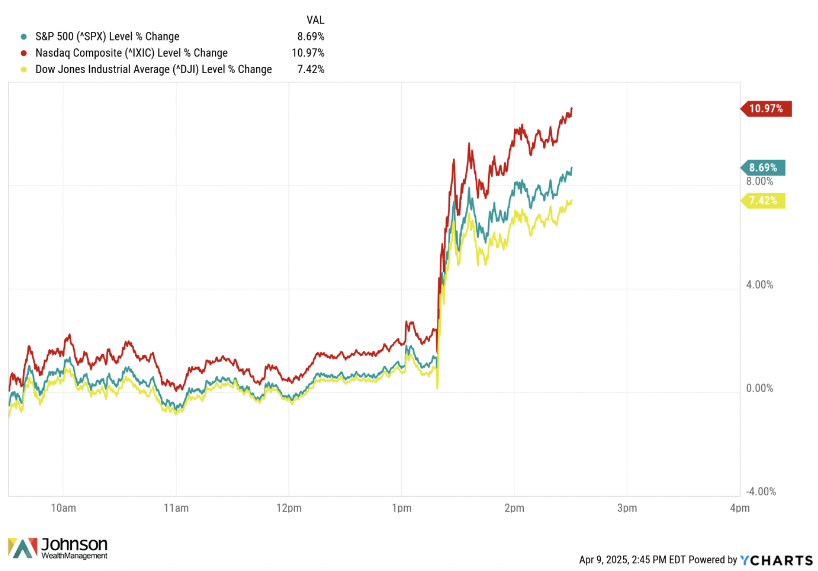
It’s totally normal right now to be fearful and curious as to where “the bottom” is in the markets and wonder if this most recent news was it. But allow me to let you in on a secret: that is virtually unknowable.
This may mean that in order for you to be a good investor, you need to think about decreasing your intake of news and social media. A dopamine-driven culture does not form durable investors let alone resilient humans. Nor does surrounding yourself with constant pessimism. As one investor put it, “The greatest trick the devil ever played was making you believe that the pessimists are the good guys.”
US stock market history is replete with pockets of short-term pain and a plethora of long-term gain.

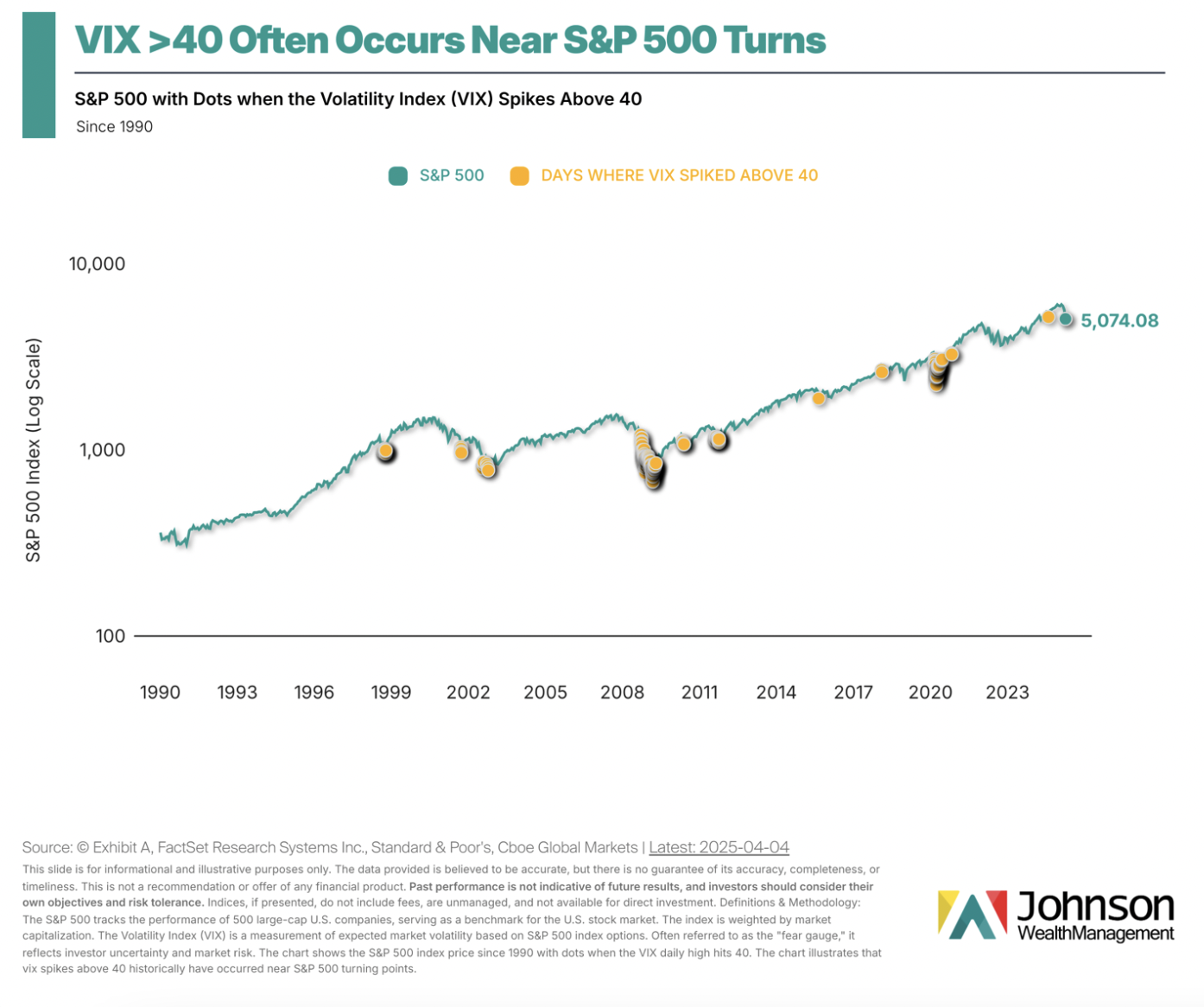
One thing we can know right now is that in the past when volatility spikes, recoveries can follow.
One must be realistic though.
Notice how those can cluster. This means the downtrend can last awhile.
The good news is that this kind of fear has historically been followed by excellent returns.

Treat stock market volatility as the regular subscription price you pay for investing for long-term returns. Those who want higher returns will need to treat market swings as an integral feature of investing.
It’s just the way it works.
Of course, this does not mean that everyone should be in stocks. Some have short-term financial needs or simply cannot handle it. Times like this are a good reminder of the necessity of risk management.
Here is something to keep at the forefront of your mind in all this.
Life is not determined by a bad few months. Nor is your investment life.
Investment portfolios and financial plans don’t normally survive making erratic trades.
Be careful that you don’t make an investing mistake now based on fear that leads to financial regret later.
# # #
Sources:
- Posted by @bespokeinvest on April 8, 2025 via X. Accessed online:
- “Thomas Sowell Discusses the Trump Tariffs” in an interview with Hoover Institution on April 2, 2025.
- “Trump Just Shredded the Economic Playbook: Here Are Your Next Investing Moves” (April 4, 2025).
# # #
Brandon Stockman has been a Wealth Advisor licensed with the Series 7 and 66 since the Great Financial Crisis of 2008. He has the privilege of helping manage accounts throughout the United States and works in the Fortuna office of Johnson Wealth Management. You can sign up for his weekly newsletter on investing and financial education or subscribe to his YouTube channel. Securities and advisory services offered through Prospera Financial Services, Inc. | Member FINRA, SIPC. This should not be considered tax, legal, or investment advice. Past performance is no guarantee of future results.