
OBITUARY: Renee Leanne Isaacson, 1961-2024
LoCO Staff / Monday, Nov. 25, 2024 @ 6:56 a.m. / Obits

Renee Leanne Isaacson passed away on September 19, 2024. She was born on April 24, 1961 in Goldendale Washington. Renee grew up in Carson, Washington and met Eric Isaacson in 1985 around the time Eric moved up there. They got married on July 6, 1991. Eric worked at a couple mills and then did timber falling, while Renee worked in a psychiatric ward at Vancouver hospital. They moved in together in 1986 in Carson, Wash. and then moved to Eureka in 1990. They got married on July 6, 1991.
Renee worked in the health center at HSU as a referral coordinator for insurances. She retired early in 2005 to become a stay-at-home mom for her twins, who were seven at the time.
She is survived by her husband Eric, her son Michael, and her daughter Molly.
Written by Molly Isaacson:
My mom was kind, light-hearted, and had an amazing sense of humor. She was hilarious and very quick-witted! I have so many of her funny quotes written down. Mom was creative and did many different crafts throughout the years. She painted rocks, canvases, and then got into sewing in 2020. She had turned a room in their house into a “craft room” and it was filled with any fabric you could think of! She made masks during the pandemic, but then transitioned to making rice packs, bags, bowl cozies, ornaments, bows, baby blankets, gnomes, and more. Mom’s favorite activity was sewing in the craft room and listening and singing along to music playing on the Alexa. Speaking of Alexa- she had one in every room! My brother and dad never quite understood, and it almost became a joke to see what they’d say about her growing collection. For the last few years, mom attended a couple craft fairs a year including the veterans memorial building craft fair and the Loleta craft fair to sell her sewing creations. I would go with her and help out and we’d spend the day chatting (and shopping the other vendor booths) together.
My mom also loved Disneyland, taking many trips over the years with her relatives Carla, Heidi, Mitchell, Alexandria, Beatrice, my brother and I (and my dad a couple times)! Her favorite was when it was decorated for Christmas, which we got to see on our last trip out there in 2018.
My personal favorite memories with mom are our family trips up to Washington to visit family. We have gone to Washington almost every summer for as long as I can remember and I have so many fond memories of those adventures. We would play music in the car and eat road trip snacks and just have the best time ever being with family. As my brother and I became adults, we would drive up ourselves and meet mom up there. Mom would sometimes visit there for a month at a time and it truly was one of her happy places. This past July, my partner and I drove up to Washington with mom! It was just like old times when we would all drive up together. We stopped at Burgerville on the way up (it’s a necessity) and then went out to Backwoods Brewery once we made it to Carson. It was a beautiful, warm night and the excitement for the upcoming week of adventures was tangible. Later that week, we visited Mt. Hood because mom had never been there. It was beautiful and extra special looking back, now.
I am extremely grateful for the memories I have and for my mom and dad for giving my brother and I the best childhood ever. We were such happy kids and our days were filled with magic, especially this time of year. My mom LOVED Christmas. Growing up, she did not get to experience Christmas magic but it made her go above and beyond so that my brother and I would always have the best Christmas ever. Our tree would be up extra early - oftentimes before Thanksgiving! My dad and brother were in charge of putting up the lights outside and they always did a beautiful job. She loved snow globes and Christmas music and we used to watch the Christmas Story 24-hour marathon every year!
My dad told one of my favorite stories that I have heard of my parents: January 1986, Renee and I decided to drive up to catch the sunrise in the snow. We got stuck in the snow and I went out in the woods to gather slabs of cedar to use for planks to put behind the wheels to get unstuck. I was pushing and she was driving. I didn’t realize at the time but she had no idea how to drive in reverse. I told her to back up and go down the main road. She accidentally got off the main road onto the side road and got stuck in the ditch and I had to do the same thing all over again! She ended up in the ditch about twice. We finally got to a spot where she got out and we were able to drive back home. We used to drive out the logging roads because I was familiar with those since it’s what I was doing while timber falling. We got stuck more than once. When we moved down here to Eureka, she wanted to go to Samoa beach and we got stuck and had to sleep overnight in the car. She could hear the ocean and swore the tide was going to come up and reach us. — Eric Isaacson
To know Renee was to love her, and she is so missed. Grief is just love. It’s the love you want to give, but cannot. How lucky are we to be filled with so much love for my beautiful mom …
###
The obituary above was submitted on behalf of Renee Isaacson’s loved ones. The Lost Coast Outpost runs obituaries of Humboldt County residents at no charge. See guidelines here. Email news@lostcoastoutpost.com.
BOOKED
Today: 5 felonies, 5 misdemeanors, 0 infractions
JUDGED
Humboldt County Superior Court Calendar: Today
CHP REPORTS
10400 Mm101 N Hum R104.00 (HM office): Traffic Hazard
7848 Mm101 N Men 78.50 (HM office): Traffic Hazard
7848 Mm101 N Men 78.50 (HM office): Trfc Collision-Unkn Inj
Alderpoint Rd / Dokweiller Rd (HM office): Trfc Collision-Unkn Inj
Lighthouse Rd / Mill Creek Rd (HM office): Trfc Collision-1141 Enrt
ELSEWHERE
RHBB: Snow in the Hills and Coastal Hail: What Drivers Face This Morning
Mad River Union: County looks to McK Amazon center for sales tax revenue
Mad River Union: Chamber lauds Leaders
Mad River Union: Use Dine, Drink & Stay Digital Passport to map your local vibes
TO YOUR WEALTH: Weathering Financial Storms: The Virtue of Emergency Funds & The Vice of Safetyism
Brandon Stockman / Sunday, Nov. 24, 2024 @ 7:05 a.m. / Money
It’s been a stormy week on the Lost Coast.
How do you prepare for financial storms that life will inevitably bring?
One of the best ways is through building an emergency fund. This is step one in personal finance, and the training wheels of money management. Let’s use an educator’s interrogative grid to nail down the fundamentals.
Who? Answer: YOU. You should have an emergency fund. Whether you are old or young, retired or still working, a seasoned or amateur investor, everyone should have one.
Why? It protects you from having to go into debt when life throws you a curveball. Jobs are lost. Vehicles break down. Earthquakes break things. Medical problems seemingly arise out of nowhere. When these kinds of events occur, you can run to your fund instead of giving in to the allurements of the credit card.
The “whys” don’t have to all be reactive though. Emergency funds can help prepare you to proactively not “stay stuck” and give you a pathway to switching careers or moving to a new place.
What? This is not an investment account. Boredom is the goal. The important thing is: it should be risk-free. Avoid investment risk and avoid terms that have penalties for withdrawal. Remember the reason for an emergency fund is so that the money is there when you need it and not at a value less than what you started with.
Where? Not in your checking account, that’s for sure. Normally the money should be earning interest in an FDIC-insured account, money market, or high-yielding savings account. After all, the current interest rate on “safe” money, which can follow US Treasuries, is higher than it has been for many years.

Click to enlarge
The key is to make your emergency fund easy—but not too easy—to access. Therefore, you might consider putting it in a high-interest savings account at a different bank than the one you regularly use as a psychological buffer. This helps you think twice before pushing the button to transfer it into your checking.
When? NOW. If you don’t have one, don’t wait another minute to start one. Go to your local bank or look for an online one. You could start setting one up faster than reading this article.
How? There are two of these Hs: how should I build this fund and how much should I put in it?
The answer to the first question is: set up an automatic withdrawal amount each month. Whether it is $50 or $500, this should automatically be set up monthly. If you make it manual, human nature will kick in and suddenly months will slide by without the account accumulating.
The answer to the second question is a bit more debatable. Three to six months of living expenses seems to be the standard. Some even say a year’s worth. I say, start with one month and build from there.
But if you’ve built past a year or two into multiple years, you’ve likely moved away from an emergency fund into an “End of the World” fund. The error of this is that your fear of risk is now munching away at your fund’s value by the stealthy inflation monster. You may need to consider investing.
After all, emergency preparedness can be a virtue, but it can also become an addiction that is a vice. This occurs when it’s no longer about preparing for crisis, but about control.
A significant part of life is engaging in risk. Safetyism can be a disease. Or, as the authors of The Coddling of the American Mind write: a cult.
Safetyism is the cult of safety—an obsession with eliminating threats (both real and imagined) to the point at which people become unwilling to make reasonable trade-offs demanded by other practical and moral concerns.1
While the authors are focused on how this way of thinking impacts children and the next generation, it can be applied in finance too. Being so obsessed with safe investments and anticipating the next emergency can hijack your future. It makes you think you’re planning for the future, when you actually aren’t. Safety, to use the word of Gollum, can be “tricksy” like that.
You can sit in government bonds forever or have cash in your local bank till kingdom come. Inflation will still eat it. You can put your money in a safe inside your house inside your gated community, and it will do just that—sit there.
Investing in stocks has been one of the best ways to beat inflation. While the purchasing power of the dollar has dropped significantly through the decades, the US Stock Market has done quite well.

Yes, prepare for the storms of life and have and emergency fund, but don’t make that your only long-term financial plan.
# # #
Sources:
- 1 Greg Lukianoff & Jonathan Haidt, (Penguin Books, 2019), p. 32.
Brandon Stockman has been a Wealth Advisor licensed with the Series 7 and 66 since the Great Financial Crisis of 2008. He has the privilege of helping manage accounts throughout the United States and works in the Fortuna office of Johnson Wealth Management. You can sign up for his weekly newsletter on investing and financial education or subscribe to his YouTube channel. Securities and advisory services offered through Prospera Financial Services, Inc. | Member FINRA, SIPC. This should not be considered tax, legal, or investment advice. Past performance is no guarantee of future results.
TINY FOOTPRINTS: Plastic Grocery Bags Are Going Away Entirely in Another Year, And You’re Gonna be Totally Ready For That Because You Are Awesome
Ashley Thomas / Sunday, Nov. 24, 2024 @ 7 a.m. / Tiny Footprints

Photo by flxlr, via Fickr. License: CC BY-NC-SA 2.0.
The phrase “the road to hell is paved with good intentions” always rubbed me the wrong way. So judgy. And yet, that’s what comes to mind when I consider the 2014 California ban on single-use plastic bags. It was a fantastic idea, and I have no doubt that the people who set it into motion had the very best of intentions.
Unfortunately, the ban led to a loophole in which stores were able to sell thicker plastic bags. According to CalRecyle, the average Californian disposed of about 11 lbs. of grocery bags per year in 2021—which is up from about 8 lbs. in 2004. Making bigger, thicker (albeit reusable) plastic grocery bags just created a bigger problem.
Yikes!
So, why does it matter? Well, despite these thicker plastic bags being reusable, they continue to end up in landfills, where they can take centuries to break down. In the meantime, the chemicals in these bags contribute to microplastics in our environment and bodies. Plastic can disrupt the human endocrine system, harm wildlife, and increase greenhouse gas emissions, just to name a few concerns.
So, what can we do about it?
• Use those reusable plastic bags. If you’ve already purchased them and they remain in your possession, do your best to bring them in from the car. If you forgot them in the car, have your friend, kid, or significant other grab them before you pay. And if you’re shopping alone, you can even pack the groceries back into your cart and transfer them into the bags when you get to the car. Or your home, if that’s where you left them. Sure, it’s inconvenient, and if it’s one of those days when you just can’t, that’s understandable. The point is progress, not perfection.
• Invest in reusable cloth bags. I carried my reusable plastic bag torch for years. I’d bought them, so I felt compelled to keep using them. But over the years I became resentful of them. Resentful of the amount of physical space they took up. In my home. In the shopping cart. That with wear and tear they became an eyesore. It sounds dramatic, yet I’m sincere when I say that purchasing reusable cloth grocery bags changed my life. Mine fold up into a tiny attached compartment, so I can throw them into my purse, where they take up hardly any space. They also fit 2-3 regular bags worth of groceries, and boast supporting up to 50 lbs. And of course, they come in an absurd array of colors and patterns to fit your personality. But any cloth bag will do—canvas, your backpack. You do you, boo.
• Consider alternatives to produce bags. When you’re picking out your apples or grapefruits from Winco, consider avoiding single-use produce bags altogether. If it’s just a few items, you can toss them in the cart and throw them on the conveyer belt. If you’re going for something like mushrooms or chili peppers, you could repurpose other kinds of bags (I think sturdy tortilla bags with zippers and bread bags are perfect for this). Or, you could invest in reusable produce bags. The mesh ones I found are food safe, BPA-free, and machine washable.
The bottom line: There’s not one “correct” way to cut back on plastic bags. If you’re already on the reusable grocery bag train, congratulations and thank you! If not, the goal is to find a strategy that works for each of us most of the time, and try to stick to it. It’s not going to solve all our problems, but I believe small changes at the individual level can turn into bigger changes within our community and world over time.
Oh, and by the way, California recently passed a new law that will ban the sale of those thicker, reusable plastic bags anyway. Starting January 1, 2026, recycled paper bags will be the only option for purchase at checkout. So it’s a great time to get another system in order before that takes effect. And I personally think the compact, foldable grocery bags make an adorable stocking stuffer for adults.
###
Ashley Nichole Thomas is a marriage and family therapist who’s passionate about shrinking her carbon footprint. In her free time she writes fantasy novels, and remains unconvinced that fairies don’t exist.
(VIDEO) Peter Santenello’s Latest Video ‘Life in the Middle of Nowhere - California’s Most Secluded Tribe’ Explores the Hoopa Valley Reservation Through the Eyes of Locals
Isabella Vanderheiden / Saturday, Nov. 23, 2024 @ 2:54 p.m. / Our Culture , Tribes
###
YouTube travel vlogger Peter Santenello is back with another video highlighting our beloved Humboldt County!
Just last week, Santenello published a video – “The California Nobody Knows” – about his adventures around Crazy River Farm, the Arcata Farmer’s Market and the redwoods with local farmer and songwriter Brett McFarland.
In his latest video, which has already racked up 152,000 views since it was posted this morning, Santenello travels out to the Hoopa Valley Reservation to chat with locals and learn more about the history of “California’s most secluded tribe.” Sam Jones, a Hoopa tribal member and tattoo artist, takes Santenello on a tour of the rural reservation and introduces him to a few family members and friends who describe the desperate situation facing their community.
“If you want to get down to it, the drug use is pretty rampant,” Jones’ friend Samuel says in the video. “It’s fentanyl and heroin, too. It hinders progress … because if you’re messed up on drugs, you never know the true potential of a person because they’re always, like, shortchanging themselves. Or else they just get taken out too quick because they die. [We]’re losing a lot of bloodlines from people passing away.”
Even so, Jones tells Santenello that he has an “uplifting sense of pride” for his community. “We’ve been here for 10,000 years,” Jone says, looking out over the Hoopa Valley from a vista point. “We’re going to be here forever, you know?”
Click “play” on the video above to tag along on Santenello’s journey to the Hoopa Valley.
###
(PHOTOS) YEE HAW! Cowboy Canned Food Convoy Returns to Old Town Eureka
Isabella Vanderheiden / Saturday, Nov. 23, 2024 @ 1:25 p.m. / Community , Feel Good , Food

Members of the local unit of the Backcountry Horsemen of California brought out their horses and mules on a rainy Saturday afternoon to collect canned goods for Food for People’s holiday food drive. | Photos: Isabella Vanderheiden
###
The Redwood Unit of the Backcountry Horsemen of California rode through Old Town Eureka on Saturday afternoon, collecting much-needed canned goods from local businesses for Food for People’s annual Cowboy Canned Food Convoy. The event kicks off the local food pantry’s annual Holiday Spirit Food & Fund Drive.
“The Cowboy Canned Food Convoy has been the kickoff for Food for People’s holiday food drives for years,” David Reed, Food for People’s Development Director, told the Outpost. “To me, it shows how taking care of our neighbors can be something we all take part in. This time of year, we’ve got everyone from high school students, businesses, our state senator, kids, families, and even cowboys and cowgirls collecting food and money to help make sure everyone has enough to eat.”
Since the COVID-19 pandemic, Food for People has seen a 30 percent uptick in people visiting the food pantry and seeking food assistance through the non-profit’s various nutrition programs, Reed said. Last year, Food for People served over 21,000 people countywide per month, “and the need is increasing.”
As is tradition, Food for People will team up with local high schools, state Senator Mike McGuire and our very own KHUM Radio for the food drive finale starting Dec. 9. You can donate canned goods and other non-perishable foods at local grocery stores and businesses around the county. Click here for a list of donation locations.
Last year’s holiday food drive “smashed” all previous records. Let’s make this year’s fundraiser one for the books, Humboldt!
###


THE ECONEWS REPORT: Solar is Coming to Hydesville!
The EcoNews Report / Saturday, Nov. 23, 2024 @ 10 a.m. / Environment

Image: Stable Diffusion.
The Redwood Coast Energy Authority is working to encourage new local generation of renewable energy through their redesigned “Feed-In Tariff” program, which provides about-market pricing and a streamlined contracting process to encourage the development of local renewable energy projects. This means projects like the new solar farm near Hydesville, a project brought forward by renewable energy developer EDP Renewables.
Jocelyn Gwynn of Redwood Coast Energy Authority and Kendra Kallevig of EDP Renewables join the show to discuss the Feed-In Tariff program and how we can help foster the development of local renewable energy projects.
HUMBOLDT HISTORY: The 1964 Christmas Flood Wiped the Town of Klamath From the Map
Sherry Moore / Saturday, Nov. 23, 2024 @ 7:30 a.m. / History
McCovey children standing at the Klamath, looking over the lost Douglas Memorial Bridge.
###
The following is an excerpt from local author Sherry Moore’s new memoir The Raging Klamath: A Playground of Plenty, which is available right now at local bookstores — and lots of other places, too — throughout the region and would make the perfect Christmas gift for the Humboldt History buff in your life. Also on Amazon.
You can also pick up a copy and meet the author at the Humboldt County Main Library in Eureka on Saturday, Dec. 14, from noon to 3 p.m., when Moore will give a presentation and host a book-signing related to the memoir — a story of the river and the people who made their homes on its banks.
###
Chapter 16: The 1,000-Year Flood
The Christmas Flood of 1964 was the worst natural disaster to strike Oregon and Northern California in recorded history. The coastlines were especially hard hit. With sustained flooding from December 18 to January 7, one span of six days registered a total of 30 inches of rain, and a staggering 10,390,000-acre feet of water flowed into the Pacific Ocean from California’s northern tributaries. With the disasters of 1953 and 1955 considered to be 100-year flood, it was not a stretch to call this catastrophic event a 1,000 year flood.
Throughout its life, the Klamath River has always been vulnerable to annual changing weather patterns that cause the river to silt, flush and alter its flow. Before 1953, the most memorable floods on record occurred during the winter of 1861-62, in January 1881, in January of 1890, and the winter of 1926-27.
The flood of 1861-1862 impacted Washington, Oregon, Nevada, portions of Idaho, Utah, Arizona and California. It was the widest-spread, longest lasting, costliest, and harshest on the animals and people, as well as the erosion and lost buildings to California. At the time, there were only 350,000 people living in California, and the cost of rebuilding would bankrupt the state. Named the “Ark Flood” because it rained for 40 days and nights in parts of California. The storms began rolling into Oregon in November and then spread southeastward. Much like 1964, warm weather systems melted high snow packs, causing all streams and rivers to swell and overflow.
Along the coast, San Francisco recorded its highest amount of rainfall ever. Nothing has come close since. Thirty extra feet of muddy freshwater poured into the salt waters of the bay for days, bringing lots of fish for the taking. To the south, masses of snakes from the Sacramento Delta slithered onto farm fields at Monterey Bay. Cattle drowned by the thousands. San Diego’s topography was forever changed from eroding hillsides.
California’s inland valleys, as well as the Mojave Desert, became huge lakes that took several weeks to drain. Sacramento was so inundated that the capital was temporarily moved to San Francisco. Approximately one thousand Chinese immigrants, afraid to leave their cabins, were swept into the Yuba River and drowned. Active hydraulic gold mining operations compounded the erosion. In their book The Great Flood of 1862, authors W. Leonard Taylor and Robert Taylor wrote, “No single industry in the history of California has generated more long-term environmental damage for such a meager economic return.”
A severe two-year drought followed the 1862 flood. Many people suffered, due to a lack of food, shelter, and other necessities. Grasshoppers consumed the parched grasslands. With so much depletion and disappearing wildlife, starving Indians in the hills resorted to rustling cattle, and ignited a war with settlers. The magnitude of cattle lost forced an end to the large vaquero ranches.
From December to mid-January of that same winter, Terwer Valley experienced four episodes of the Klamath River cresting and ebbing. Ten to 15 feet of soil eroded away around Fort Terwer. All 20 of its buildings were lost, forcing most of the soldiers to live in tents. One of the officer’s tents, along with other wreckage included still-edible winter squash, washed up on Crescent City beaches. Nearly a century later, land surveyors found two partially-buried rock fireplaces from the fort at the east end of the Glen near the “Big Tree.”
The Waukell Indian Agency (Resighini Rancheria), was wiped out. Those who dwelt near the river lost homes and food-storage buildings. The narrow road into Terwer Valley was closed-off for several days, leaving Yurok canoes as the only mode of transportation up and down the river.
Sketch of Fort Terwer, via the Library of Congress.
With the Klamath Indian Reservation in shambles and the river still running high in March, government officials decided to abandon the fort and agency. Soldiers left Terwer for good on June 10, 1862. Thirty-nine of them escorted Indians to the new Smith River Reservation, 43 miles up the coast. Fort Lincoln was built between Crescent City and the Smith River to garrison the soldiers. The Yurok who stayed on the Klamath were glad to see the soldiers go, even though they got along with them.
The Smith River Reservation continued to grow, with several hundred more displaced Indians coming in from Humboldt County, significantly reducing the Eel River and Redwood Creek Indian populations. Some escaped into the hills, or went back to where they once lived and adapted to the white man’s culture. Indian agent Morgan Tucker, who spoke several Native American languages, stayed at Requa with a couple of soldiers to keep peace for many years.
In 1863, William H. Brewer, a professor of agriculture, visited Klamath and Crescent City. He was amazed at the assortment of trees that had come down the Klamath River and were washed up along the coastline. “They were tremendous in size and length,” he reported. “The eight-mile beach at Crescent City was covered to a width of 200 yards and a depth three to eight feet with debris. There was enough wood on the beaches to supply the timber market for years.”
The next major flood for Klamath happened in January of 1881. According to Morgan Tucker the depth of water was higher than that of 1862 and his experience was similar. Enormous uprooted trees came crashing down the river, homes were lost, and livestock drowned. Upriver, 100 miners from Sawyer Bar on the Salmon River were washed out, and, with no provisions, were soon starving. They made it to Little Ike Camp, a Karuk village on the Klamath River, where they were generously fed dried salmon, deer meat and acorn soup before being supplied with enough provisions to go back to Orleans.
Nine years later, in 1890, another great flood struck. Hunter Creek, a small tributary close to the mouth of the Klamath, was 10 feet deep in some places. At Martin Ferry Bridge, 40 miles upriver, the Klamath rose 100 feet, and carried away the local suspension bridge. The oldest resident there said this was the highest level in his lifetime. His observation is reinforced by Terwer records showing the river crested three feet higher than in 1862.
Fellow friend and woodsman Stacey Fisher, who grew up in Hunter Creek, offered this perspective:
I noticed a large spruce tree at Hunter Creek that had a flood ring around it. The ring was 15 feet above its bottom base. The old-timers said it was from one of the late floods of the 1800s. The 1964 flood didn’t come close. Before the 1964 flood, a couple of loggers were walking in some alders at Starwein Flat on the Klamath River. One logger stumbled over the top of a redwood tree sticking out of the ground. I was called in to dig out what turned out to be a huge old-growth redwood. This tree had been buried for many years from one of the early floods. Some of the outside was rotted, but the tree was basically sound. I dug down over six feet and bucked it up. Three timber-transport truck loads were hauled out.
For the following 37 years, flooding on the Klamath was unremarkable. However, in 1927 flood waters crested just two feet lower than what we would experience in 1953. The new town of Klamath was rapidly taking shape and had a lot of recovery work to do after about three feet of water consumed it. That flood damaged or destroyed all it touched, including Dad’s family restaurant. Small cabins, barns, and fencing went down the river, which stayed high from December to March.
The gravel from under the newly built Douglas Bridge was carried by powerful currents to the sandy islands at the mouth of the Klamath. Safford Island (Bear Island) was heavily eroded. Named for a local fisherman and his family, the island was a popular summertime destination, with cabins and docks. Visitors enjoyed rowing in from the mainland to picnic and fish. A large open field was perfect for pick-up baseball games. Even cows swam over to graze on the thick grass. Occasionally, platforms were erected with lights and a live band for dancing. Indian also performed ceremonial dances. Longtime local resident Mary Larson Wakeman remembered the island this way:
The Charles Gibbon family lived and farmed on the island. They had a nice garden and orchard. Sweet peas and cherries were a favorite. Sometimes neighbor kids, including my dad and his brother, paddled over to the island and played with their kids, showing up for a meal. With 16 children I don’t think their parents even noticed them at the dinner table. Wildlife like deer and bear frequented the island and still do today.
About 15 feet off of the Klamath Glen Road, just before it turned up the hill near McBeth’s, there was an old-growth redwood tree that I estimated to be about 150 years old in 1964. About 18 feet up from the ground, there was a four-inch band of chocolate-colored silt embedded in the bark. The 1964 flood had only come close to its base, so I often thought maybe the river had earlier flowed high on this north side, before changing course to now flow on the south side. Another scenario was that an avalanche had come down the hillside and created a dam near this tree, backing up the water. Without a lot more scientific study and analysis, one couldn’t tell if this was the flood of 1862, 1881, 1890, or another flood before the white settlers came. Regardless, it was a remarkable and perplexing sight.
###
Thirty-four California counties were declared a disaster area in 1964. President Lyndon Johnson designated Northern California a natural disaster area. Californian Governor Pat Brown declared a state of emergency. The US Dept. of Civil Defense, along with the county supervisors and local government agencies had their hands full rendering assistance and aid. Among those counties that suffered the most were Del Norte, Humboldt, Siskiyou, Mendocino, Trinity and Sonoma. Besides the Klamath, some of the other area rivers recording record-breaking heights were the Smith, Trinity, Van Duzen, Mad, and Eel, which crested at mind-boggling 46 feet. Today, travelers on Highway 101 near Miranda have to look well above their heads to see the marker memorializing this measure of a 1,000 year flood. However, the Mad River was two inches below the 1955 flood, because the new spillway at Ruth Lake Dam, despite overflowing and eroding, held back a sizeable amount.
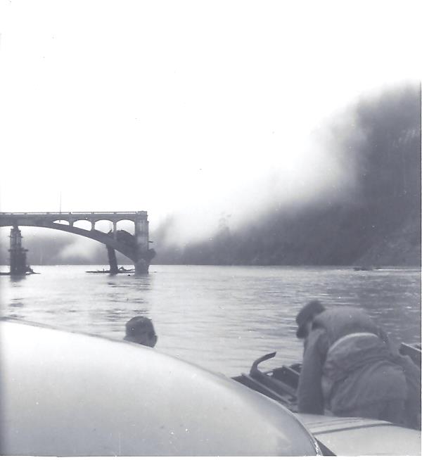
1964 Barge over Klamath River. Photo courtesy Kay Tubbs.
In addition to the town of Klamath, other communities wiped out were Alton, Metropolitan, Holmes, Shively, Pepperwood, and Ti-Bar. Local areas that suffered major damage included Crescent City, Gasquet, Smith River, Orick, Fernbridge, Hoopa, Weitchpec and Orleans. In Oregon and Northern California, a total of 47 people lost their lives, mainly due to drowning, mudslides and helicopter crashes. Three deaths occurred on the Klamath. One was a drowning, a second was due to overexertion, and the third occurred when a Red Cross worker was struck by a helicopter blade at Happy Camp while loading supplies. Within the state of California alone, nearly 2,000 people suffered injuries.
In one way or another, everyone in the disaster zone was impacted. About 5,000 homes, 400 businesses and 1,100 farm buildings were destroyed or heavily damaged. Close to 7,900 families suffered losses in Humboldt and Del Norte counties, alone. Over 8,400 head of livestock, nearly half of them cattle, drowned. Several thousand acres of agriculture land was ruined.
Transportation and general services including utilities, public safety, and road maintenance were crippled. Eighty percent of county roads suffered significant damage, and 16 major bridges washed out. Several sections of Interstate 5 from Washington down to Northern California were closed for a week or more.
The iconic Fernbridge over the Eel River in central Humboldt County was saved by men working day and night removing jammed debris from under the structure with a crane. Further south, when logs began lodging up against another bridge near Scotia, a brave soul ventured onto the pileup with a box of dynamite, and blew it apart. Other bridges were not so lucky, and residents made use of a networks of backroad to get from one place to another. Thankfully, Orick’s Kane Bridge and the Mad River Bridge north of Arcata held, making 101 drivable from the washed-out Douglas Bridge to Eureka. With road and railroad transportation impaired, larger communities like Arcata and Eureka that were outside the flood zone also suffered. Badly-needed supplies were brought in by ocean barges and airplanes.
Highway 299 from Arcata to Redding was closed in many areas, forcing travelers to detour on unpaved backroads. Highway 96 was among the most damaged. From Willow Creek to Yreka, large sections of road and several bridges on the Trinity and Klamath rivers were gone, isolating Hoopa, Orleans, Happy Camp, and several Indian villages.
One-third of Highway 169 from the upper Klamath to Johnson had disappeared. Helicopters and boats were dispatched for emergency situations and supply drops, and gas was rationed. This area suffered the most, and remained isolated for quite some time.
In Del Norte County, the greatest roadway loss was the Klamath Bridge. The Dr. Fine Bridge on the lower Smith River and the Chetco River Bridge miraculously survived, which kept Highway 101 open from Klamath to Crescent City and on to Brookings, Oregon. Highway 199, from Crescent City to Grants Pass, Oregon, endured the loss of three major bridges. Slides in the Smith River gorge were huge, and wiped out several miles of road. It would take months of repair work to open this route.
Bridge damage in the Klamath-Trinity drainage area was unbelievable. Upper Klamath residents reported seeing 100-foot high piles of debris flowing by. The bridge at Willow Creek connecting Route 96 with 299 was completely destroyed. In the Weitchpec-Orleans-Somes Bar vicinity, every bridge was taken out, including the beautiful, prized-winning suspension bridge at Orleans, and the little jeweled-like US Forest Service suspension bridge at Ishi-Pishi. The Martin’s Ferry bridge broke apart in water flowing 115 feet deep.
An eyewitness recalled watching the Douglas Bridge on the lower Klamath give way:
Before the structure failed, debris was backed upstream several hundred feet, although the river level was several feet from the top of the arches. At times, small logs would come hurtling downstream, hit the floating debris, and shoot into the air completely over the structure. The pressure of the river, against the debris, finally pushed 400 feet of the bridge out of the way, and the debris shot downstream with a roar. Another 200 feet of the bridge was left in shambles.
Due to impassable transportation routes and the loss of several thousand jobs, the logging and lumber industry faced a number of challenges. The main source of employment for coastal communities, California was the second largest lumber producer in the U.S. Before the flood, ninety percent of all lumber products were transported by the Pacific North Coast Railroad. Three rail bridges were out, along with 30 miles of uprooted and twisted rail. Some 70 pieces of rolling stock (cars) were either destroyed or missing. It would take 177 days to fully reopen the railroad between Humboldt County and San Francisco. With so much damage to transportation infrastructure, the state had to draw on funding appropriated for Southern California to hire contractors and cover the cost of rebuilding.
Mills shut down or remained in only partial operation for several months. Just getting into the woods to fall timber was difficult, because roads were perilous and weather conditions bad. Millions of board feet of logs and lumber went down the rivers and ended up on beaches and in harbors. Mills that lost timber in the 1955 flood had raised their log and lumber stockpiles at least five feet higher, but that precaution didn’t matter with this flood. Logs weighing 30 tons each were lifted from their resting place and swept downriver like missiles. Hundreds of millions of board feet of timber were lost. The Pacific Lumber Company estimated their loss to be 23,000,000 board feet in lumber alone, plus 18,000,000 in logs.
Well before waters shrank back into their natural banks, help arrived from all over the country. Every branch of the US military was involved, especially the Army Corps of Engineers. Construction workers dropped jobs in other regions to work in flood-stricken areas. San Quentin Prison sent 4,000 inmate workers. Many non-profit organizations in and outside the region contributed greatly, especially the Red Cross and Salvation Army. Those small airports not destroyed were bustling with personnel, vehicles, helicopters and planes rescuing stranded people and delivering supplies such as medicine, food and water. With grasslands layered in silt, and with much hay lost, animals also needed food and medical support. The USDA flew in free grain, and tons of hay. Planes came from as far away as Georgia to assist. Local airports like McNamara Field in Crescent City, Rohnerville Airport in Fortuna, Murray Field in Eureka, and Arcata Airport in McKinleyville were like beehives.
Local people who owned aircraft volunteered assistance. One of them, Les Pierce, told me how he risked life and limb rescuing people and making deliveries in a small helicopter. He recalled flying low in the most dangerous and stormy conditions imaginable, often with no sleep. Once, it was so cold his hand nearly froze to the cyclic stick.
Les, along with all of the other courageous volunteers, should never be forgotten. They operated in virtual war zone, working against Mother Nature to move people out of harm’s way. Small planes even landed on highways to pick up stranded people unable to drive in either direction.
My classmate Dean Hupp, whose parents Aileen and Chuck co-owned Panther Creek Lodge, recalled how his family had left the day before to spend Christmas with relatives in Los Angeles. They got stranded by severe weather in the small town of Garberville in southern Humboldt County. Three days later, they were able to catch a private plane back to Del Norte County. When they were finally able to get to the lodge, little was left. The Hupps and DeVols, two young couples who had pooled their life savings to run a vacation and fishing lodge, were forced to give up on that dream.
Although severely eroded, the Iron Gate Dam spillway on the upper Klamath held, but its powerhouse was submerged, resulting in a lengthy shut down. Every regional dam was near peak flow. The new Trinity and Lewiston dams on the Trinity River managed to hold back a sizable amount of water, and reduced some flooding below. The Trinity River did not break the 1955 flood records because of the 372,200 acre-feet of runoff stored behind the dams. Nonetheless, an impressive 231,000 cubic feet of rushing water per second was calculated at Hoopa. The Klamath reached flows of 557,000 cubic feet per second, and submerged the town of Klamath under 15 feet of water.
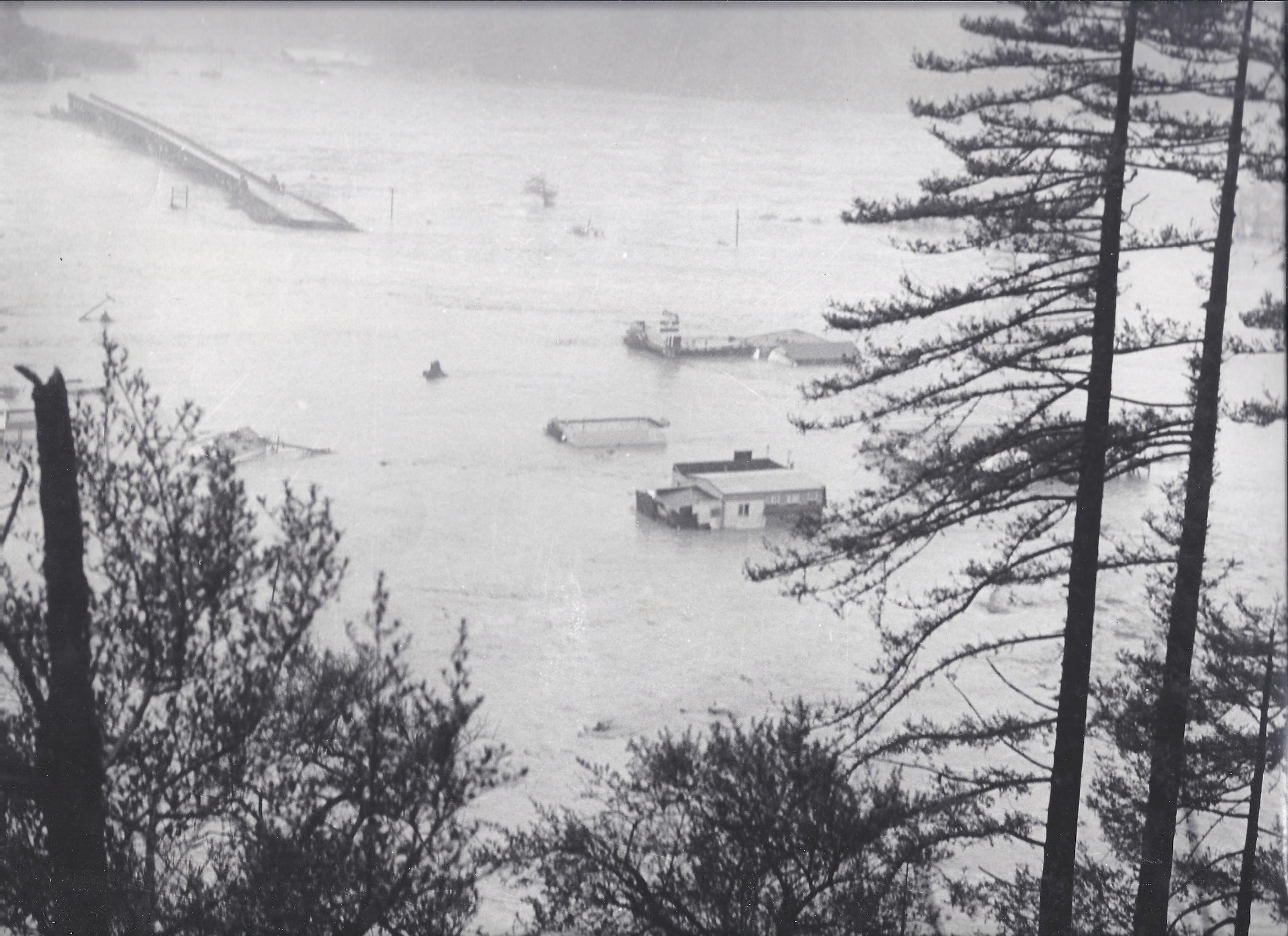
Town of Klamath. Photo: James Yarbrough.
At Weitchpec, the water level was 13.7 feet higher than the 1861-62 flood, and 19.5 feet higher than the 1955 flood. Much of this huge increase in height was believed to have been caused by an immense surge in the Salmon River. A massive 2-3-million-cubic-yard landslide six miles up the Salmon dammed the river, then let loose, suddenly amplifying the already-disastrous flows of the Klamath, Trinity, and Scott rivers. According to California High Water 1964-65, published in 1966 by the California Dept. of Water Resources, the North Coast region experienced $190 million in damages — $71 million in the Eel River Valley and close to that in the Klamath River Basin. However, upon further study and evaluation, the overall total cost was later estimated to be $450 million, or the equivalent of $3,510,000,000 today.
Where I lived on the lower Klamath, our community was extremely grateful to have not lost a single life in the 1,000-year flood of 1964. However, the loss of property, jobs, businesses, and, truth be told, our very way of life, created unimaginable hardship. Klamath, Del Norte County’s second largest town with a population of 850, had been erased from the landscape. Three hundred houses, every downtown business, and our beloved bridge had been swept away, with nothing left in town but a few skeletal remains of buildings surrounded by gaping holes. The Terwer-Klamath Glen area, with a population of 1.000, experienced similar destruction. Many of the radar base families also lost their homes. Major Cavalli, commandant of the 777th Radar Air Force Base, immediately arranged for 20 mobile homes to be hauled from Malmstrom Air Force Base in Montana to Klamath. Additional government trailers were brought in for other flood victims, and parked wherever they could find a decent spot — whether a trailer park, a piece of property donated by a generous owner, or, as in my family case, next to the house we would put back together piece by piece.
###
You like history? Consider a subscription to the Humboldt Historian, a journal of the Humboldt County Historical Society. The Humboldt County Historical Society is a nonprofit organization devoted to archiving, preserving and sharing Humboldt County’s rich history. You can become a member and receive a year’s worth of new issues of The Humboldt Historian at this link.