
OBITUARY: Malena Russell, 1974-2024
LoCO Staff / Thursday, Sept. 12, 2024 @ 6:56 a.m. / Obits
Malena
Russell passed away on July 21, 2024 at the age of 49, after a battle
with pancreatic cancer. Malena was born in Banning, Calif. on
September 22, 1974 to her parents Bette Rosamond and Dave Kindley.
Malena grew up in Eureka, where she loved to be outdoors with her two
brothers, David and Willis. You could also always find Malena at her
dad’s woodworking Shop, Kindley’s Burl. Family was Malena’s
core value even as a child.
Malena went on to attend Eureka High School. During her junior year she met the love of her life, James Russell. Shortly after graduating Malena gave birth to their daughter, Holley, on Halloween of 1993. Not long after she gave birth to her son, Cody, May 26, 1997. Being a mom came easy to Malena. She made sure she gave her children a beautiful and loving childhood, and taught them strong family values. Her greatest joy, though, was becoming a “Mimi” to her seven grandchildren: Cadance, Kinsley, Gabriella, Swasey, Winslow, Arlo and Malinda.
Malena was not only a selfless and caring mother, but also human. Malena worked as a caregiver at many local facilities, some of which include: Adult Day Health Care, Humboldt County Adult Rehabilitation and Idaho State Mental Institution. She had a passion for helping others, which speaks strongly to her character and who she was as a person. She was always putting others before herself.
Malena was an amazing human, who always had a smile on her face and a joke ready. She loved making the people around her laugh, and feel loved/appreciated. She will be missed greatly by all who knew her.
Malena will be missed dearly by her husband James Russell, daughter Holley Stevenson (husband Trent Stevenson, and grandchildren Winslow & Kinsley Stevenson, Cadance Biane.) son Cody Russell (wife Olivia Smith, grandchildren Gabriella, Swasey, Malinda Russell, & Arlo Smith), brothers David and Willis Kindley, mother Bette Kindley, nieces, nephews, and countless friends and extended family.
Malena is preceded in death by her father Dave Kindley, grandparents Elmer and Doris Kindley, and sister-in-law Glenna Kindley.
She was interred in Eureka. Her celebration of life will be held on September 14 at the Portuguese Hall in Arcata. If you would like to be invited, please reach out to the family directly for specific information. The family is asking for everyone to please pray for them during this tragic time.
###
The obituary above was submitted on behalf of Malena Russell’s loved ones. The Lost Coast Outpost runs obituaries of Humboldt County residents at no charge. See guidelines here.
BOOKED
Today: 2 felonies, 15 misdemeanors, 0 infractions
JUDGED
Humboldt County Superior Court Calendar: Today
CHP REPORTS
BRICELAND THORN RD / SEELY RD (HM office): Trfc Collision-No Inj
ELSEWHERE
RHBB: The field is set: Meet the candidates officially running for California governor
RHBB: Willits Faces Night of Reckoning as City Council Considers Declaring a Financial Emergency
RHBB: Raging Grannies, Protest Signs, and Community Voices at International Women’s Day Rally in Eureka
RHBB: Two Airlifted After Major Crash on Highway 20 Near Spring Valley Road in Lake County
OBITUARY: Danny Eugene Olson Jr., 1982-2024
LoCO Staff / Thursday, Sept. 12, 2024 @ 6:56 a.m. / Obits

Danny Eugene Olson Jr. was born September 13, 1982 to Danny Sr. and Brenda Olson in
Eureka, and passed away August 26, 2024 in Mineral Springs, Arkansas.
Danny was an incredibly kind, loving, gentle soul. Always looking for the positive in life. He had the sweetest smile and infectious laugh. He loved music, fishing, animals and nature in general. He loved to tinker and could fix anything that was broken, especially cars and electronics.
Danny proudly served his country in the U.S. Air Force Reserves. He then went on to driving truck, mostly long haul. Although he stepped away a few times to challenge himself in other professions, he would ultimately find himself back in the driver’s seat seeing the countryside and making friends along the way.
Although Danny has left us far too soon and completely heartbroken, he has given us all the beautiful lasting memories of his 42 years of life that will never ever be forgotten and will help to carry us through this unbelievable loss.
Danny is preceded by his grandfather Melvin “Mel” Gross, his great grandfather John Mitts Sr, his great grandmother Florence Mitts, his grandmother Joyce Gross and his great uncle Jon Mitts.
Danny is survived by his mother Brenda Olson, his father Danny Olson Sr. (Jan), his brothers Shane and Cole Olson, his grandfather Robert Olson, his grandmother Cheri Olson, his aunts, Teresa Welch (Herman), Teri Gross and Melanie Noe (Larry).
###
The obituary above was submitted on behalf of Danny Olson’s loved ones. The Lost Coast Outpost runs obituaries of Humboldt County residents at no charge. See guidelines here.
OBITUARY: Rosalie Agnes Watts (Kayser), 1947-2024
LoCO Staff / Thursday, Sept. 12, 2024 @ 6:56 a.m. / Obits

Rosalie
Agnes Watts (Kayser)
February
26, 1947 - August 29, 2024
Rosalie was born and raised in Vancouver, Canada. She was the second eldest of her four siblings: Marlene, Janice, Ken and Terry Kayser.
When she was 18, she moved to the States, and started her adult life in San Francisco. She attended Simpson Bible College, worked various jobs, and started a family. Rose was a very loving, caring, uplifting person to know, always finding and focusing on the positive things in life. She had a special way about her that influenced others to enjoy an active lifestyle outdoors.
She found beauty in God’s creation and had a strong desire for adventure and exploring the outdoors. You would always find her out in the fresh air, from hiking in the woods, quad riding in the desert or beach, boogie boarding at the beach, exploring caves, backpacking into volcanoes, to taking her daily walks. She was talented in her crafts with nature, rock collecting, natural furniture making, etc.
She had many friends and family who will miss her dearly. Rose is survived by her four children and their spouses: Jed and Janera Watts, Starline and Mark Pitlock, Mindy and Brad Adorador, Larz and Summer Watts. She is also survived by her eight grandchildren: Janessa, Chandler, Sharlene, Kendall, Bella, Nicolas, Oliver and Reid.
Rose also left behind her special companion, Kelly Rarey, whom she enjoyed the last year of her life with, as they still traveled, and lived life to the fullest together. At 77 years old, Rosalie (Rose) passed away peacefully to join our Lord and Savior, Jesus Christ in Heaven, where her husband of 55 years, Lawrence Watts, is also. We are comforted in knowing she is in eternity with God.
Friends and family are invited to attend her Celebration of Life on Saturday, September 28 at 2 p.m., held at Freshwater Park: 3100 Freshwater Rd. Eureka, CA 95503. Please email to RSVP: mlwatts76@yahoo.com
###
The obituary above was submitted on behalf of Rosalie Watts’ loved ones. The Lost Coast Outpost runs obituaries of Humboldt County residents at no charge. See guidelines here.
Public Health Shuts Down Eureka Elks Lodge For Two Weeks After Continued Shigella Exposures
LoCO Staff / Wednesday, Sept. 11, 2024 @ 5:37 p.m. / Health

Eureka Elks Lodge. | Google Street View.
###
Press release from the Humboldt County Department of Health and Human Services:
Humboldt County Department of Health & Human Services (DHHS) Environmental Health officials shutdown the Elks Lodge in Eureka for two weeks starting Wednesday, Sept. 11, after health requirements provided last week to avoid closure, following a Shigella outbreak, were unable to be met.
Following the original outbreak, facility staff made sure the facility underwent a deep cleaning, and symptomatic individuals were directed not to participate in any food-related activities. However, it was recently discovered that some infected individuals continued to frequent the facility and serve food and drinks to patrons on at least two separate occasions.
DHHS Public and Environmental Health staff have been working closely with Lodge employees for the past two weeks after it was discovered that attendees at an Elks dinner on Wednesday, Aug. 28, may have been exposed to the illness.
On Sept. 3, Public Health was notified of three confirmed cases and five suspected cases of shigellosis contracted by people who had attended the event. Since the original event, Public Health Communicable Disease staff have identified a total of six confirmed cases and 61 probable cases through their contact tracing efforts.
Case numbers may continue to shift as individuals are tested through their health care providers and results become available to Public Health Communicable Disease staff for processing.
Twenty-three individuals who attended the event went to the emergency room with symptoms and at least one was admitted.
Individuals who have been at the facility in the past two weeks and are experiencing symptoms should contact Public Health.Earlier in August, there were at least three confirmed cases in the county. The two clusters do not appear to be connected.
Shigella germs are found in stool, and infection is spread by eating food or drinking liquids contaminated by an infected person, or when a person touches a contaminated surface or object and then touches their mouth or puts the object into their mouth. People who have contracted shigellosis typically experience a fever, abdominal cramps and diarrhea which may be bloody.
Onset of shigellosis symptoms usually occurs one to two days after exposure—but may take longer—and lasts around a week. Infected people can remain contagious up to six weeks after symptoms resolve.
Most people with shigellosis recover completely without severe complications. People with weakened immune systems are at higher risk. In rare cases, Shigella may cause bloodstream infections, seizures, kidney failure or arthritis.
The best way to prevent the spread of shigellosis is to wash hands:
People with shigellosis should:
- Before, during and after preparing food
- Before eating
- Before and after caring for someone who is sick
- After using the toilet
- After blowing your nose, coughing or sneezing
- After touching garbage
- After changing diapers or cleaning up a child who has used the toilet
- After touching an animal, animal feed or animal waste
- After handling pet food or pet treats.
- Stay home from school or from health care, food service or childcare roles while sick
- Abstain from sharing food
- Abstain from swimming and hot tubs
- Abstain from having sex for at least two weeks after symptoms resolve.
Anyone experiencing vomiting or diarrhea should wait until symptoms have resolved for 24 to 48 hours to avoid spread of stomach bugs or bacteria. It is especially important for individuals in health care, daycare and food services roles to follow these precautions.
If you are experiencing symptoms, contact your primary care provider or call Public Health at 707-268-2182.
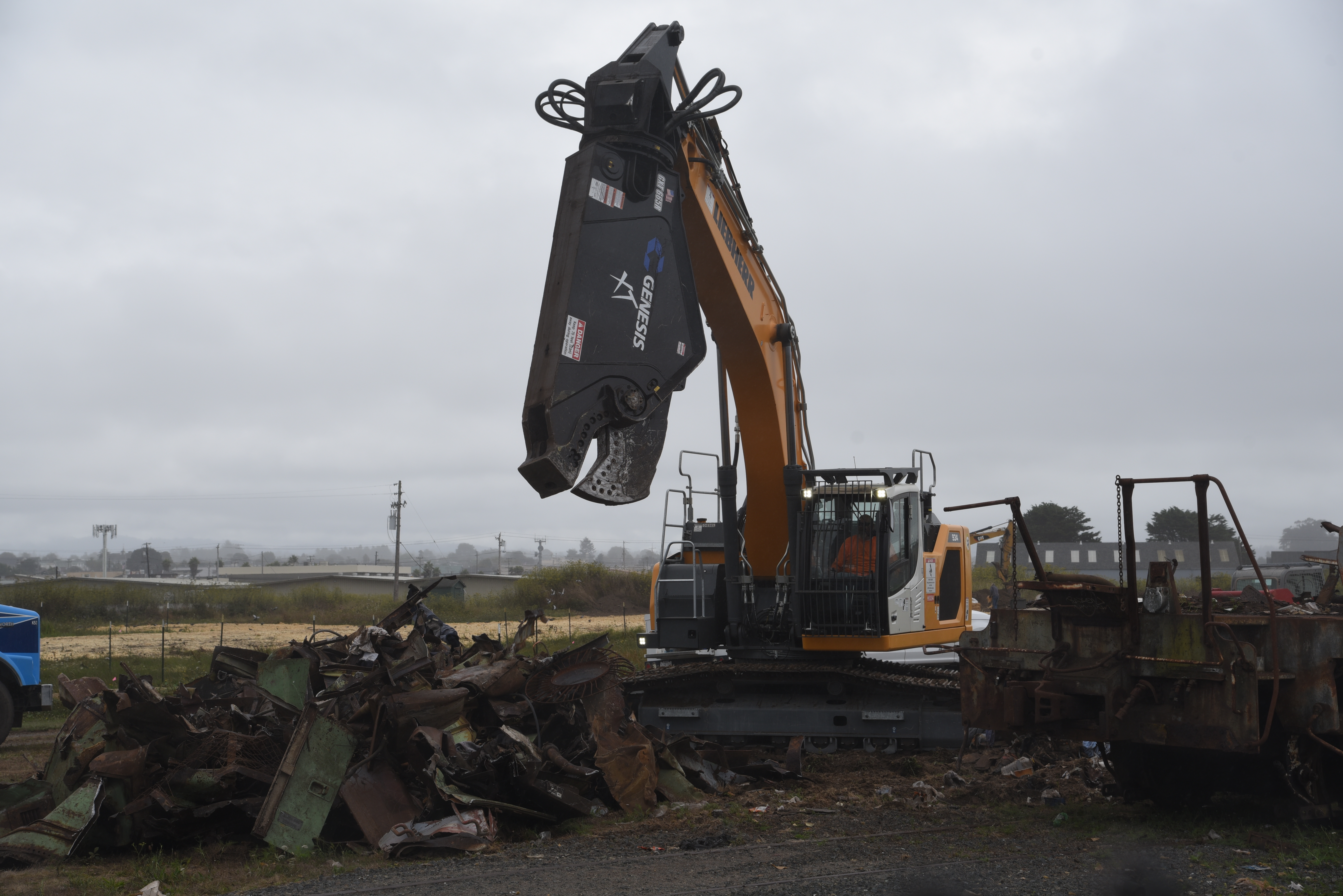
Twenty-Six Years After They Were Stranded There By Floods, The Balloon Track’s Zombie Trains Are Finally Moving Out — Mostly in Pieces
Hank Sims / Wednesday, Sept. 11, 2024 @ 3:14 p.m. / Infrastructure

Photos: Dezmond Remington.
PREVIOUSLY:
- City of Eureka Cracks Down on Balloon Track Zombie Trains; Their Days, it Seems, are Numbered
- (PHOTOS) Crews Begin Dismantling Balloon Track Zombie Trains
- Zombie Trains on Balloon Track Property Get Fresh Coat of Paint, Remain a ‘Public Nuisance’
###
They’ve been there so long that they’ve kind of just blended into the legend and lore of the Eureka waterfront, but those zombie locomotives stranded on the Balloon Track for the last quarter-century are finally moving out, nearly 10 years after they were officially declared a public nuisance.
Tim Callison, project manager for Security National — the company that owns the Balloon Track — sounded plenty relieved on the phone today.
“They figure it should take ‘em about a week to get everything out,” he said.
Callison said that the locomotives’ owner — a Matt Monson, out of Turlock — was saving one of them, which has some historic value. They’re strapping it on to some sort of big rig and trucking it back down someplace near Stockton. The rest of the engines are being scrapped on-site with heavy machinery.
Monson last spoke to the Outpost in 2016, when he promised action on the engines. He wrote:
I am in the slow process of moving them , this is a big and costly undertaking and takes time. Currently I am waiting for the moving equipment to be modified to move these … I am looking forward to getting these engines out of there and put this whole night mare behind me … matt
This was after Monson made an abortive attempt to get the trains out of here nearly a decade ago.
Callison said that the dysfunctional state of the railroad contributed to the stalemate over getting the giant, ungainly machines out of here. No one could just roll ‘em out to greener pastures.
The Balloon Track is a former spur line of the Northwestern Pacific Railroad, which ran between the Bay Area and Humboldt until 1998, when the storm-wracked line could finally bear no more traffic. The engines have been stranded on the site for at least that long.
The North Coast Railroad Authority, the public agency that managed the battered line, was finally dissolved in 2021 and its assets handed over to the new Great Redwood Trail Agency.
Missing Eureka Woman Found ‘Alive and Well’ After Three-Day Search Effort, Says Humboldt Sheriff
LoCO Staff / Wednesday, Sept. 11, 2024 @ 3:01 p.m. / Missing
Press release from the Humboldt County Sheriff’s Office:
Jean Marie Etherton, age 63, of Eureka, was located safe in Eureka around 11:30 a.m. on Wednesday, Sept. 11. Etherton has been reunited with her family and is currently receiving medical treatment at a local hospital.
A thorough Search and Rescue (SAR) operation was launched on the morning of Sunday, Sept. 8 after Etherton’s family reported her as a missing person to the Humboldt County Sheriff’s Office (HCSO). Deputies, HSCO SAR volunteers and K-9s, California Rescue Dog Association (CARDA) volunteers, U.S. Coast Guard Sector Humboldt Bay Helicopter, as well as HCSO thermal drone and ATVs were deployed as resources during this search effort on the first day. More resources were called in the days following the initial search launch, and a mutual aid effort ultimately led to the successful location and rescue of Etherton.
The Humboldt County Sheriff’s Office would like to thank the following agencies for their participation in the successful and effective search and rescue operation:
- Humboldt County Sheriff’s Office Search and Rescue
- Sonoma County Sheriff’s Office Search and Rescue
- Marin County Sheriff’s Office Search and Rescue
- Santa Clara County Sheriff’s Office Search and Rescue
- Alameda County Sheriff’s Office Search and Rescue
- California Rescue Dog Association (CARDA)
- California Office of Emergency Services (Cal OES)
- Humboldt County Sheriff’s Office of Emergency Services
- Redwood Acres, for providing housing of volunteer personnel
- Ridgewood Heights Baptist Church, for allowing the Command Post to operate onsite
- United States Coast Guard
- Public citizens, for calling in tips and checking video surveillance
###
PREVIOUSLY:
(PICTURES) A New Monument at Berry Summit Will Honor the Legendary Horse Mountain Skiing Scene
Hank Sims / Wednesday, Sept. 11, 2024 @ 11:41 a.m. / Our Culture

PREVIOUSLY:
###
Remember that cool Humboldt Historian story we ran back in January about downhill skiing at Horse Mountain?
If you missed it, go check it out at the link above. It was all about a very fun, very brash, very Humboldt scene that used to exist out there. The scene boasted a ski lodge, rope tows, a snack shack and all sorts of homespun lingo and legend particular to the place.
Well, back in August a local group called “The Horse Mountain Grippers,” dedicated to memorializing that scene, finally got the go-ahead from Caltrans and county government to install an interpretive kiosk at Berry Summit that will tell the tale of Horse Mountain skiing in really beautiful detail. The Grippers raised all the money to build the thing themselves.
Next week they’re having a big event out at Berry Summit to break ground on the project, and if you’re a historically-minded citizen, a hardcore ski nerd, a friend of the Walsh family or just someone infused with the Hiouska spirit, you are invited to attend! They’ll be gathering at the Summit on Friday, September 20 at 11 a.m. for “fun, refreshments, giveaways and celebration.” Ski apparel is very much encouraged!
Below, please find designs for the eight gorgeous panels they’ll be installing up at the Summit, so that future travelers who stop off to check the view might be edified about this quintessentially — and, alas, bygone — Humboldt subculture. Click to enlarge.


