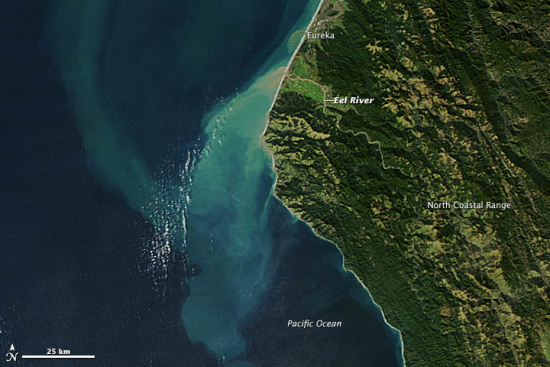
Sediment flowing from the Eel River after this last rainstorm, Dec 9, 2012 (photo from here.)
During the last rainstorms and for days afterwards, sediment rolled down the Eel River and into the Pacific Ocean (see above photo taken Dec. 9th.) For a river its size and even for those much larger, the Eel has some of the highest recorded rate of suspended sediment flowing through it. In fact, according to Friends of the Eel River, the Eel River has some of the highest sediment load in the world, “carrying fifteen times as much sediment as the notoriously muddy Mississippi, and second only to the 3,000 mile long Yangtze River in China.”
The Eel River naturally carries a great deal of sediment in the rainy season. “The root of this,” says Scoot Greacen of Friends of the Eel River “is the geology: we sit on scraped-up, piled high seabed.” This is a relatively young landscape that is susceptible to moving. Landslides are a fact of life in Humboldt. In addition, the large amount of rainfall in this area contributes to washing particles of soil from the hillsides down into the river. Many places in Humboldt had over 10 inches of rain during these last storms.
This last storm event, according to Scott Greacen of Friends of the Eel River, “not only mobilizes surface material on all the unprepped roads and bare dirt… but also triggered landslides which we would usually expect in late springs, when the landscape is saturated with water.” A large contributing factor is sediment load from man-made sources. The logging in the past as well as currently can contribute. Road building and incorrect grading of hillsides also add to the situation.
Each big storm leaves a signature deposit of sediment where the river empties into the sea. The plume shown above indicates that the load can be deposited relatively far from the coast.
Map of the Eel River watershed from here.
CLICK TO MANAGE