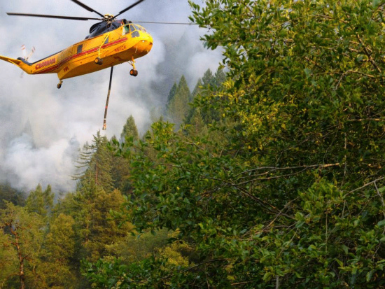
A huge helicopter brought in to fight the fire (Photo by Ben Beaver, a local who is fighting the fire.)
Between the Orleans Complex (Dance and Butler Fires) and the Salmon Complex a total of around 10,000 acres has burned in the last 9 days since the first fire started.
An excerpt from The Orleans Fire Complex Press Release states:
The Butler Fire burned actively until the night time inversion established at approximately 10:00 p.m. Fire continues to back into the community of Butler Flat and around Nordheimer Flat. Protection of residences (and the associated water systems) throughout the river corridor remains a priority.
The fire moved over the proposed southern containment yesterday and is well established in the Hammel Creek drainage and firefighters have begun working on reestablishing fire line from the 1977 Hog Fire and scouting for other contingency lines.
Firefighters continue to work on dozer and handlines on the northern and western fire containment lines. Steep terrain, limited access to the fire, and compromised visibility due to smoke continues to challenge firefighters.
Weather in the fire area today is predicted to be similar to yesterday, with the inversion layer lifting slightly earlier, which could result in increased fire activity.
There were some areas where the fire broke through containment lines. The InciWeb sstated,
The fire burned areas in key drainages below the containment lines slopping over in 2 places yesterday initiating containment line construction plan that will be re-establishing lines from the 1977 Hog fire. Structure defense continued on residences along the river east to Nordheimer. Dozer line construction has progressed on the northern lines. A handline supported by fire hose was established around the Butler Flat community as the fire continues to back into the area. The fire arrived at the Butler Flat control line at 9:35 p.m. [See photo below taken at 11 last night.]
The InciWeb also announced that “A community meeting will be held at the Forks Community Hall, in Forks of Salmon at 7:00 p.m. tonight on Tuesday August 6, 2013.”

(Photo by Ben Beaver)
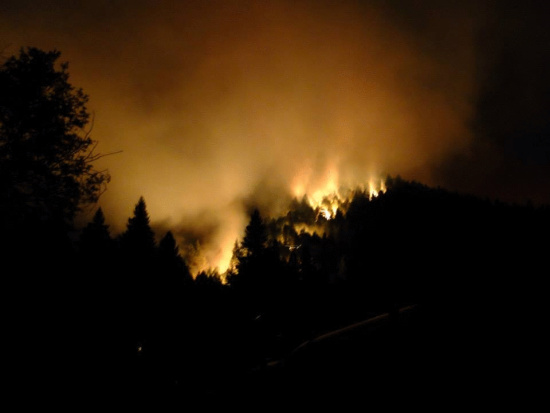
Photo taken at around 11 last night looking at the Butler fire above the Beaver family residence. (Photo by Ben Beaver.)
Full details of the fire below:
Complete Orleans Fire Complex Press Release:
August 6, 2013, 8:00 a.m.
For Immediate Release
Orleans Complex, Six Rivers National Forest
Orleans Complex Fire Information (530) 618-2101 Salmon River Complex Fire call (530) 841-4451
The Orleans Complex is comprised of two fires: Butler Fire (started 7/31) and Dance Fire (started 7/29-100% contained). Northern California Interagency Team 2 is managing the incident.
Community Meeting:
A community meeting will be held at the Forks Community Hall, in Forks of Salmon at 7:00 p.m. tonight on Tuesday August 6, 2013.
Health Advisory:
The North Coast Unified Air Quality Management District (NCUAQM) continues to extend their smoke advisory for Del Norte, Humboldt and Trinity Counties, noting that there are separate advisories for Forks of Salmon, Klamath Glen, Orleans and Weitchpec. For further information call the 24 hour Air Quality Advisory Information at 1-866-BURN-DAY or check the district’s website at www.ncuaqmd.org.
Butler Fire
Detected: Wednesday, July 31, 10pmCause: Under Investigation
Fuels: Timber and Brush
Estimated Size: 3,699 acres
Containment: 4%
Committed Resources: Approximately 838
Structures Damaged or Destroyed: 0
Location: Klamath National Forest, approximately 10 miles east of Somes Bar, California.
Closures:
The following closures are in effect:
Going into or being upon National Forest System lands in the area beginning at the intersection of Wooley creek and Highway 93 (county Road 2B01), then continuing northeast along Wooley creek to the intersection with Timothy Gulch, then continuing southeast along Timothy Gulch to the intersection with the Pacific crest Trail, then continuing southeast along but not including the Pacific Crest Trail to the intersection with the Russian Wilderness boundary, then continuing south/southwest along the Russian Wilderness boundary to the intersection with Forest Route 39, then continuing west/northwest along but not including Forest Route 39 to the intersection with Highway 93 (county Road 2B01), then continuing northwest along Highway 93(county Road 2B01) to the starting point, as shown on the attached map.
Oak Bottom Campground
Highway 93 (Forks of Salmon Road) is closed from the east at the Highway 96 intersection and from the west at the Siskiyou County Road yard.
Nordheimer Campground is closed.
The land around the Salmon River is closed 300 feet from the high watermark between the confluence of Wooley Creek and the confluence of Nordheimer Creek.
Summary:
The Butler Fire burned actively until the night time inversion established at approximately 10:00 p.m. Fire continues to back into the community of Butler Flat and around Nordheimer Flat. Protection of residences (and the associated water systems) throughout the river corridor remains a priority.
The fire moved over the proposed southern containment yesterday and is well established in the Hammel Creek drainage and firefighters have begun working on reestablishing fire line from the 1977 Hog Fire and scouting for other contingency lines.
Firefighters continue to work on dozer and handlines on the northern and western fire containment lines. Steep terrain, limited access to the fire, and compromised visibility due to smoke continues to challenge firefighters.
Weather in the fire area today is predicted to be similar to yesterday, with the inversion layer lifting slightly earlier, which could result in increased fire activity.
Please see http://www.inciweb.org/incident/3577/# for updates and a map of the Orleans Complex.
Previously:
- Butler Fire—Crews and Residents Work to Save Structures
- Butler Fire Control Lines Being Established
- Residents of Butler Flat Wait as Fire Predicted to Reach Homes Tonight
- Butler Fire Up to 1,463 Acres; Still Burning Out of Control
- Fires and Smoke across Northern California
- Orleans Complex Map and Evening Update with Air Alert
- Butler Fire 0% Contained and 500 Acres Burning
- Butler Fire near Somes Bar Burns 400 Acres/Dance Fire 95% Contained
- Thursday Update with Photos and Video of the Dance Fire
- Dance Fire 90 Percent Contained
- Dance Fire near Orleans up to 650 Acres
- Video of Orleans Fire
- First Photos and Report From Near the Orleans Fire
- Fire Closes Hwy 96 near Orleans-[Evacuations]
CLICK TO MANAGE