[For LoCO’s chronological list of fire updates, go here.]
A quick LoCO programming note for wildfire watchers out there: One of the best sources updates is the website InciWeb, an “interagency all-risk incident information management system.” If you go to their homepage you’ll find a master list of the most recent dispatches from wildfires across the nation. There are many fires, more than NorCal residents likely care to sift through.
Thus, LoCO has raided InciWeb’s RSS feed and added just the most local fires to our popular “Elsewhere” section. InciWeb updates from the Mad River (Ruth/SoHum), River (Denny/EastHum), South (Burnt Ranch), Route (Hyampom), Fork (Hayfork) and Gasquet (Del Norte) complexes will now pop up there as soon as they’re published.
Here are the latest stats and updates on our region’s wildfire complexes:
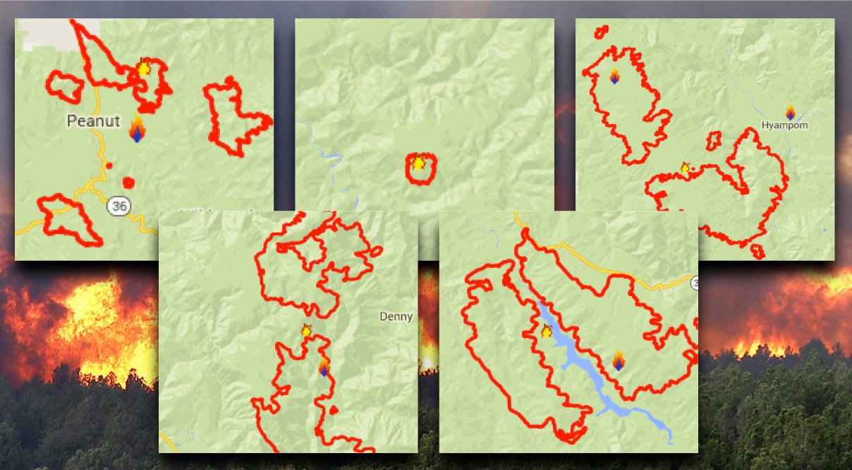
 Mad River Complex
Acres: 15,760; Containment: 10%; Personnel: 748
Representatives from the US Forest Service and incident management teams working on the Mad River and Route Complexes will hold two meeting to discuss the current status of the recent lightning-caused wildfires affecting the area. The first meeting will be held Friday, August 7, beginning at 6:00 p.m. at the USFS Ruth Guard Station, 19500 Lower Mad River Road, 1.3 miles east of the Ruth Store in Ruth. The second meeting will start Saturday, August 8, 11:00 a.m., in Mad River at the Lamb Creek Christian Center, located at the junction of Highway 36 and Forest Service Road 1.
# # #
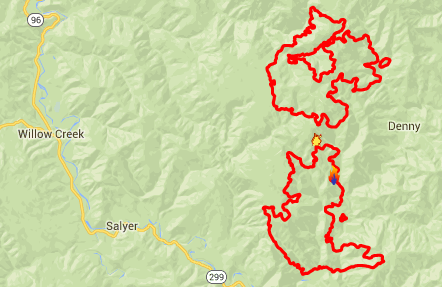 River Complex
Acres: 8,536; Personnel: 521
A forest closure order has been implemented to close the trails and roads within the area, on the Shasta-Trinity National Forest, pursuant to 16 USC 551 and 36 CFR 261.50(a).
The order prohibits going into or being upon the National Forest System lands within the River Complex Closure Area.
Please see attached forest closures orders and map.
# # #
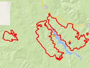
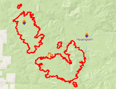 Route Complex
Acres: 13,959; Containment: 2%; Personnel: 359
Fire behavior increased on several fires within the Route Complex. The estimated acreage is now 13,959 with 359 fire personnel assigned to the Complex.
The south side of the Complex includes the Buck and Tierney fires. Crews conducted burnout operations yesterday evening on the Tierney Fire to reinforce containment lines on the southeast side of the fire with plans to continue today.
On the north side of the Complex, the Johnson and Blake fires are expected to combine together with crews working to secure the west side of the fires. The Hitchcock Fire is joining the south end of the Johnson Fire where a dozer line is being constructed to tie in with the South Fork of the Trinity River. Crews are working to secure the Chance Fire to the north of the Blake Fire. Firefighters continue to make progress securing the upper east portion of the Kerlin Fire, located north of the Johnson Fire.
Aircraft provided support to burnout operations on the Tierney Fire. The smoke from the numerous fires burning throughout the region has lead to air quality warnings being issued for both Humboldt and Trinity counties.
Warmer and drier weather is expected today, with a possibility of scattered thunderstorms today and Friday. These conditions typically lead to an increase in fire activity.
Road closures remain in effect due to hazard trees falling, tree torching and uphill runs of the fire. Forest Service Road #1 remains closed approximately 5 miles north of Highway 36 at Forest Service Road 2N12. Van Duzen Road (County Road 511) is closed to non-residents, from Browns Canyon to junction with Ruth-Zenia Road (County Road 502). Highway 36 closure now reduced on the East side, closed at Forest Glen rather than Route 3 and remains closed on the West end at Lower Mad River Road.
# # #
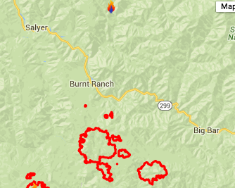 South Complex
Acres: 13,931; Containment: 3%; Personnel: 356
The South Complex consists of approximately nine known fires, five of which are currently less than 100 acres. Firefighters continue to prioritize life and structure protection; assessing and preparing residences in the eventuality that fire reaches them, and building containment lines in front of the fire to protect homes.
Firefighters worked last night to secure line on the northeast corner of the Pelletreau Fire, bringing fire slowly down toward the South Fork of the Trinity River, and on the north side of the fire toward the Kerlin Creek Road to stop northward spread. Structure protection will continue today at the Wigdon Place, Skunk Ranch, and the properties around Panther Creek. Dozer line held well along the north and west sides of the Castle Fire, and line constructed on the Clark Fire long Forest Road 5N60 is also holding, with firefighters working today to maintain that line. Firefighters will continue this work today, constructing line and carefully bringing fire to new and existing lines to create and maintain good containment. No structures have been reported damaged or destroyed at this time.
Weather is predicted to change today, with hot, dry conditions prevailing once the inversion lifts. An increase in fire activity is expected with these changing weather conditions. A chance of lightning is predicted for early Friday morning, which could bring erratic winds as well as the potential for new lightning starts.
- Castle Fire: 6650
- Pelletreau: 4050
- Pattison: 2565
- Clark: 385
- Olson: 175
- Smaller Fires: 106
The Red Cross has established an evacuation center at the Solid Rock Christian Church at the intersection of State Route 3 and Tule Creek Road in Hayfork. The Salvation Army is also offering water and meals to residents at the Church, whether or not they are staying at the evacuation center.
# # #
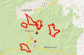 Fork Complex
Acres: 13,333; Containment: 7%; Personnel: 1,165
The Trinity County Solid Waste, Hayfork Transfer Station (“Hayfork Dump”) will be open tomorrow, August 7th, on its regular schedule. Highway 3 access to the dump will be open tomorrow.
Mandatory Evacuation Notice: The area of 13 Dips Road is now under mandatory evacuation due to an increase in fire behavior.
New Road Closures: The 347 Road is closed. The 30N19 Road is closed southeast of the 347 Road to the junction of the 30N41 Road.
# # #
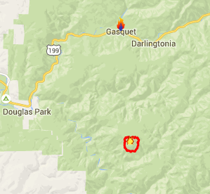 Gasquet Complex
Acres: 1,000; Containment: 2%; Personnel: 175
Yesterday, the Incident Command Post was moved from the Gasquet Ranger Station, to the Gasquet Mountain School, with the Base Camp which will be providing supplies, meals, showers and other support for the troops, is being built at Ward Field.
With the predicted clearing skies in the coming days, a Temporary Flight Restriction, (TFR) of 10 nautical miles has been established for the air assets on the fire. There is predicted clearing and warming this week, with thunderstorms coming back into the forecast, starting Friday and into this weekend.
On the Gasquet Ranger District there are currently 6 active fires. Several other fires were contained on initial attack. The following six fires on the Gasquet Ranger District are now being managed by Southern California Incident Management Team 2, Incident Commander David Kelly.
- Bear Fire - 160 acres
- Coon Fire - 235 acres
- Peak Fire - 220 acres
- Summit Fire - 5 acres
- Williams Fire - 200 acres
- Feeder Fire - 90 acres
Additional crews and equipment have been ordered and are arriving at the Incident Command Post. Motorists can expect increased fire traffic along Highway 199 and in the local communities along Highway 199 corridor.
CLICK TO MANAGE