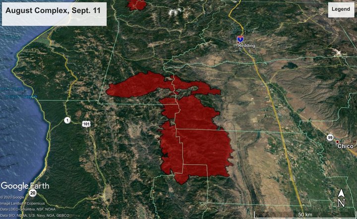
Overview of the 726,000-acre August Complex fire — the largest wildfire in California history — as of this morning.
AUGUST COMPLEX
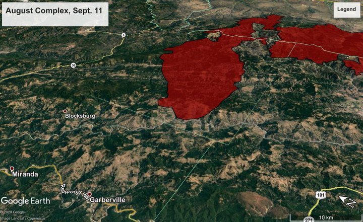
First things first: As of this writing, the August Complex fire moving in toward the southeast corner of Humboldt County — previously it was known as the “Hopkins Fire,” and briefly as the “Elkhorn Fire” — remains on the east side of the Eel River. The fire has not burned into Humboldt County.
However, the Alderpoint Road corridor between Highway 36 and the southern border of the county remains under evacuation orders, and a wide swatch of Southern Humboldt east of Highway 101 — including Garberville, and all the way up to Myers Flat — is under an evacuation warning, meaning that residents are asked to be ready to get out at a moments notice.
Humboldt County’s Office of Emergency Services just released a kind of busy and difficult-to-parse map showing the state of evacuation orders and warnings, and services offered to residents who have had to flee their homes. Zoom in: Areas in red with a thick red border are under evacuation orders; areas in yellow with a thick yellow border are under evacuation advisories. (Areas in yellow with a thin yellow border are the fire itself):
Humboldt County appears to be sticking with the “Hopkins Fire” name for the sake of continuity, but since this morning — when several fires in the region officially merged into one, contiguous blaze — everyone else is calling it the August Complex. It’s over 725,000 acres in size, and for management purposes it’s being divided into three zones: North, West and South.
The North Zone is the one of most immediate concern to Humboldt County and neighboring communities like Ruth and Mad River. It’s only about 15 miles from downtown Garberville, as the crow flies:
This morning, US Forest Service Public Affairs Officer Bridget Litten sent the following update, which includes today’s scope of work on the fire:
With limited resources assigned to the August Complex-North Zone, the priority will be on structure protection in the Ruth Valley, south of Ruth (Six Rivers National Forest). As the fire becomes more active throughout the day, firefighters will reposition to provide structure protection where needed. On the North perimeter, (Shasta-Trinity National Forest) the priority is to improve the containment line along Forest Road 35. Firefighters will continue to use tactical firing operations to widen the containment lines and stop the forward progress of the fire. The east perimeter near Red Bluff is in mop-up and patrol status.
Litten also sends word that this link on the interagency Inciweb system will contain future updates on the August Complex-North Zone, though it doesn’t seem to be quite operation as of this writing.
RED-SALMON FIRE
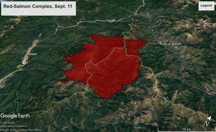
Up in the northeast corner of the county, the Red-Salmon fire stands at around 83,000 acres, with 19 percent containment. The communities of Denny and Forks of Salmon are under evacuation advisories.
According to the incident management team, the fire is posing a threat to cultural resources along Tish Tang Creek. Here’s their scope of work for today:
Fire crew efforts will be focused today on repositioning containment lines to prevent fire spread towards both the community of Forks of Salmon and towards Highway 93. Fire behavior predictions suggest that once the inversion lifts today, there is the potential for fire spread in all directions. The fire is actively backing in Tish Tang Creek forming alignment for potential future runs impacting cultural and resources values in the area. The 10N02 Road will serve as a primary line for containing the fire east of the Hoopa Valley Reservation. Mastication equipment will be clearing fuels around Horse Trail Ridge in anticipation of future firing operations. There is still a critical need for suppression resources to continue prepping existing lines and build new fire containment lines, as resources are stretched extremely thin throughout the state and Pacific Northwest.
Here’s the Inciweb page for the Red-Salmon Complex.
SLATER FIRE
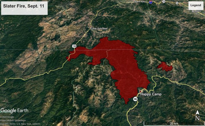
The Slater Fire, which started near Happy Camp Tuesday and has since burned north, crossing Highway 199 into Oregon and prompting evacuations in Del Norte County, stands at around 140,000 acres and is moving toward Cave Junction. Oregon Caves National Monument has been closed.
The Devil Fire — visible to the right of the main fire in the graphic above — was about 4,500 acres in size this morning. According to an email from the incident management team this morning, it “remains unstaffed.”
Both fires are uncontained.
Happy Camp is evacuated, and today firefighters are dealing with spots that are still burning and mopping up in that town. Evacuation orders in Gasquet have been lifted, and firefighters are mopping up there was well.
Here’s the Inciweb page for the Slater Fire.
OAK FIRE
The Oak Fire, which broken out just north of Willits on Monday — briefly threatening the town and closing Highway 101 for a spell — stands at an estimated 1,100 11,000 acres as of last night, with 40 percent containment. Evacuation orders have been lifted for Brooktrails and the Sherwood Road area to the northwest of the city center, except for one stretch along Highway 101.
CLICK TO MANAGE