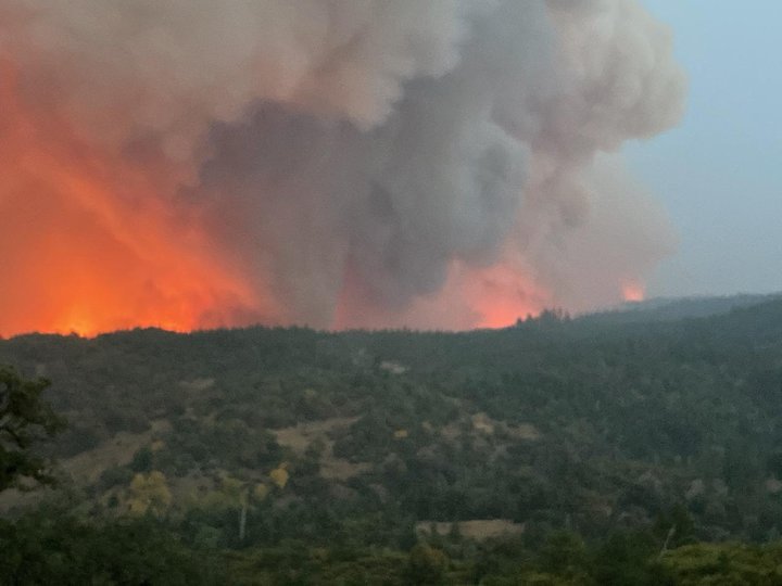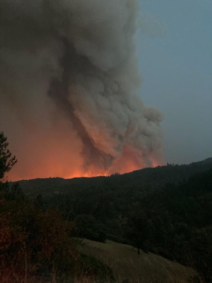
Yesterday’s view of the West Zone August Complex. | Mendocino County Sheriff’s Office.
Calfire press release:
- Incident Start Date: 9/10/2020
- Incident Start Time: 2:58 p.m.
- Incident Type: Wildland Fire
- Cause: Under Investigation
- Incident Location: Mendocino, Humboldt, Del Norte, & Trinity County
- Calfire Unit: Mendocino & Humboldt Del Norte August Complex
- Total Size: 755,603 acres
- August Complex West Zone Size: 49,009 acres
- Containment: 0%
- Expected Full Containment: 9/30/20 Civilian Injuries/Fatalities: 0
- Firefighter Injuries/Fatalities: 0
- Structures Threatened: 13,924 Structures
- Damaged: 0
- Structures Destroyed: 0
Current Situation: Calfire has entered into Unified Command on the August Complex West Zone with the Mendocino County and Humboldt County Sheriff Offices. Calfire’s unified team and the U.S. Forest Service are engaged in a coordinated response to take suppressive action on the August Complex, which has been split into three zones to effectively provide a response for the communities at risk.
Resources from across the state of California as well as Montana, Utah, Texas, and New Jersey have been assigned to assist on the August Complex West Zone. The overall acreage of the August Complex has decreased due to more accurate mapping, intel and rezoning of the incident.
Last night the fire remained active making runs up drainages where the fire and topography aligned. Spotting and torching were observed early before humidity levels increased around 2 a.m. Potential for active fire behavior will continue through the day today.
Fire along the west flank is in alignment for multiple runs to the north in a series of drainages. Excessive smoke has hindered the operation of aerial firefighting resources, which is especially problematic because much of the terrain is steep and inaccessible to ground resources.
Evacuation Orders & Evacuation Warnings & Road ClosuresHUMBOLDT COUNTY: For the latest road closures and evacuation information in Humboldt County please visit Humboldtgov.org/evacmap
EVACUATION ORDER: Areas south of Casterlin Road, including all properties on Casterlin Road, to the Mendocino/ Trinity County Line and east of Dyerville Loop Road and Bell Springs Road to the county line.
EVACUATION WARNING:
- All areas west of Bell Springs Road to Highway 101 spanning from Elk Creek Road / Dyerville Loop Road to the Mendocino / Trinity County Line in Southern Humboldt County.
- All areas east of Alderpoint Road spanning from Highway 36 to Casterlin Road, not including all properties on Casterlin Road.
ROAD CLOSURES:
- Alderpoint Road from Fort Seward Road to Dyerville Loop Road
- Bell Springs Road at County line
TRINITY COUNTY EVACUATION ORDERS:
Ruth, Zenia, Kettenpom, Hettenshaw Valley
EVACUATION WARNINGS: Communities of Ruth Lake, Mad River, Forest Glen and Post Mountain
MENDOCINO COUNTY:
For the latest road closures and evacuation information in Mendocino County please visit https://tinyurl.com/MendoEvac
EVACUATION ORDERS:
- Zone S: South of the County Line, East of Bell Springs Rd, North of Bell Springs Creek and West of the North Fork of the Eel River.
- Zone Q: South of the County Line, West and North of the North Fork of the Eel River and North and East of Bald Mountain road
- Zone E: South of the county Line, East of the National Forest boundary, North of Forest Highway 7 and West of the county Line near the M2.
- Zone N: North of the Middle Fork of the Eel River including the Eel River Ranger Station and Black Butte Store, West and South of the National Forest Boundary, East of Williams Creek.
- Zone D: South and East of the Eel river, North of Bentley Basin and West of the National Forest Boundary
- Zone C: North of the M1, East of the National Forest Boundary, south of Forest Highway 7.
- Zone B: West of Evacuation
- Zone A, North of Jack Hollow Creek and Thatcher Creek, East of the Middle Fork of the Eel River, South of Green Lambert Canyon through Bentley Basin to the M1 and South of the M1, to include Timber Ridge, and Bentley Ridge, and Hayshed Basin.
- Zone A: West of the county line, south of Anthony Peak and North of Hull Mountain.
- Zone J: East of Elk Creek, North and West of the National Forest Boundary, South of Thatcher Creek
- Zone F: East of the National Forest boundary near Garcia Creek, South of Thatcher Creek, west of the County Line and North of the County Line on Hull Mountain.
- Zone H: West of the National Forest Boundary, North of Thomas Creek and the Eel River, East of Twin Bridges Creek, South of Bald Mountain.
- Zone I: West of Elk Creek, South of Deep Hole Creek, North of the National Forest Boundary.
- Zone J: East of Elk River, north of Deep Hole Creek, east of Eden Valley, south of Thatcher Creek.
- Zone W: West of the Eel River, north of Deep Hole Creek, east of Eden Valley including the entire valley floor, south of Eden Creek. EVACUATION WARNINGS:
- Zone U: South of the County Line, East and North of the East Branch of the South Fork of the Eel River, West of Bell Springs Rd.
- Zone T: South of Bell Springs Creek, East of Bell Springs Rd, North of Iron Peak and Simmerly Rd, West of the Eel River
- Zone R: West and south of Mina Rd, South of the North Fork of the Eel River, East of the Eel River.
- Zone P: South of the County Line, East of Mina Rd North of Hulls Valley Rd and West of Hulls Creek.
- Zone O: South of the County Line, East of Hulls Creek, North of Mendocino Pass Rd, and West of Williams Creek.
- Zone L: South and West of Mendocino Pass Rd, West of The Middle Fork of the Eel River, north of Eel River Ranch Rd, East of Hill Rd and Short Creek Rd.
- Zone K: West and North of the Middle Fork of the Eel River, East of Redwine Spring, South of Hill Rd and Eel River Ranch Rd.
- Zone X: North of Eden Creek, East of Hearst Willits Rd, South and West of the Eel River.
- Zone G: West of the County Line, North of the Eel River and Van Aresdale Reservoir, East of the Eel River, South of the National Forest Boundary.
- Zone AB: South of the Middle Fork of the Eel River, west of Eden Creek, north of Salt Flat and east of Salt Creek
- Zone AC: East of Brushy Mountain, south of the fire road on Salt Flat, west of Eden Valley and north of Bald Mountain
- Zone AD: South and west of the Eel River, north of Foster Mountain Road, east of the ridge west of Willits Road
- Zone AE: North of Twin Bridges Creek, east of the Eel River, south of Brushy Creek and west of Brushy Mountain
ROAD CLOSURES:
- Private driveway near Williams Creek is closed to north bound traffic
- Bell Springs closed to north bound traffic at Lundblade Ranch Road
- Mina Road is closed to north bound traffic at the bridge over the North Fork of the Eel River
- Mendocino Pass Road closed to east bound traffic just east of the Williams Creek Bridge
- Hearst Willits Road at the bridge, closed to east bound traffic
Evacuation Centers
Mendocino County: Covelo High School, 76280 High School Street, Covelo, Ca
Trinity County:
- Humboldt County Fairgrounds: 1250 5th Street, Ferndale, CA 95536
- Southern Trinity High School Located at 600 Van Duzen Road
Humboldt County:
- Humboldt County Fairgrounds 1250 5th St., Ferndale, CA Road Closure Maps: For updated road closure information visit: https://humboldtgov.org/evacmaphttps://tinyurl.com/MendoEvac
Animal Evacuation Centers:
Small Animals: Ukiah Animal Shelter 298 Plant Rd. Ukiah, CA 95482 Small &
Small & Large Animals:
- Round Valley Rodeo Grounds 22830 S. Airport Rd. Covelo, CA
- Humboldt County Fairgrounds 1250 5th St., Ferndale, CA.
ASSIGNED RESOURCES
- Engines: 88
- Water Tenders: 18
- Helicopters: 9
- Hand Crews: 6
- Dozers: 64
- Other: 2
- Total Personnel: 766
- Cooperating Agencies: California Highway Patrol, California Department of Transportation, Trinity County Sheriff’s Office, California Department of Corrections and Rehabilitation.

CLICK TO MANAGE