West Zone of August Complex Grows to 108,996 Acres; Containment Shrinks to 65 Percent
Smoke from the August Complex is drifting to coastal Humboldt
Calfire press release:
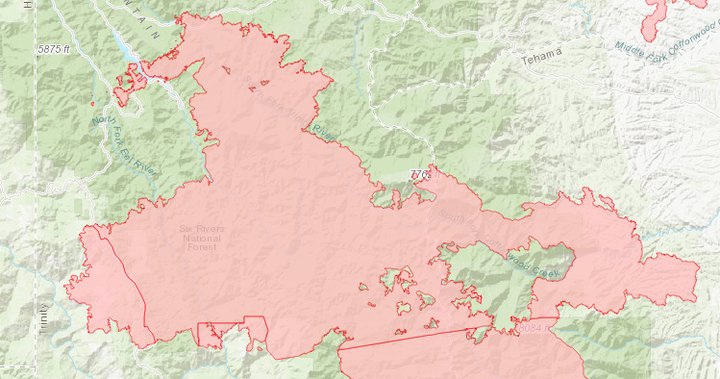
The August ComplexWest Zone has burned 108,996 acres, spans approximately 195 miles of fire line and is 65% contained with more than 1,600 firefighters battling the fire from the air and the ground.
Over the last several days, Incident Commanders have been monitoring weather reports and the fire burning in the Yolla-Bolly Middle Eel Wilderness which is part of the August Complex – North Zone.
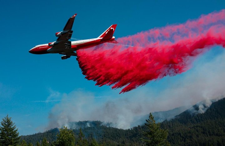
Firefighters attack the August Complex from the sky. | InciWeb
In preparation for the potential impact that the forecasted red flag wind event could have on the fire in the Yolla-Bolly Middle Eel Wilderness, firefighters are working diligently from the air and the ground to strengthen and reinforce containment and control lines.
Yesterday, strong winds pushed the fire from the Yolla-Bolly Middle Eel Wilderness south west towards control lines, prompting evacuation orders being issued for areas north east of Covelo and south of Kekawaka in Mendocino and Trinity Counties respectively.
An evacuation warning was issued for the Island Mountain area in Humboldt County and several evacuation warnings remain in place in Mendocino County including the addition of an evacuation warning for Zone V. Overnight, the fire was active in the Travis Ranch area where firefighters protected homes, clearing vegetation and extinguishing spot fires.
For the latest road closures and evacuation information in Humboldt County please visit Humboldtgov.org/evacmap
EVACUATION ORDERS: NONE
EVACUATION WARNINGS: Zone HA: Areas east of Bell Springs Road, to Trinity County line and south of Pipe Creek to Mendocino County line.
ROAD CLOSURES: NONE
TRINITY COUNTY
EVACUATION ORDERS:
Rural area in the vicinity of Hull Creek Road.
Zone TA: North of the Mendocino County line, east of the Humboldt County line, south of Kekawaka Road and west of Zenia Lake Mountain Road.
EVACUATION WARNINGS: Zenia, Kettenpom
ROAD CLOSURES: NONE
MENDOCINO COUNTY
For the latest road closures and evacuation information in Mendocino County please visit https://tinyurl.com/MendoEvac.
EVACUATION ORDERS:
Zone E: South of the county line, east of the National Forest boundary, north of Forest Highway 7 and west of the county line near the M2.
Zone C: North of the M1, east of the National Forest boundary, south of Forest Highway 7.
Zone B: West of Evacuation
Zone A, north of Jack Hollow Creek and Thatcher Creek, east of the Middle Fork of the Eel River, south of Green Lambert Canyon through Bentley Basin to the M1 and south of the M1, to include Timber Ridge, and Bentley Ridge, and Hayshed Basin.
Zone A: West of the county line, south of Anthony Peak and north of Hull Mountain.
Zone J: East of Elk Creek, north and west of the National Forest boundary, south of Thatcher Creek.
Zone F: East of the National Forest boundary near Garcia Creek, south of Thatcher Creek, west of the county line and north of the county line on Hull Mountain.
Zone I: West of Elk Creek, south of Deep Hole Creek, north of the National Forest boundary.
Zone J: East of Elk River, north of Deep Hole Creek, east of Eden Valley, south of Thatcher Creek.
Zone R: West and south of Mina Road, south of the North Fork of the Eel River, east of the Eel River.
Zone P: South of the county line, east of Mina Road north of Hulls Valley Road and west of Hulls Creek.
Zone O: South of the county line, east of Hulls Creek, north of Mendocino Pass Road, and west of Williams Creek.
Zone Q: South of the County Line, West and North of the North Fork of the Eel River, North and East of Bald Mountain Road.
Zone S: South of the County Line, East of Bell Springs Rd, North of Bell Springs Creek and West of the North Fork of the Eel River.
EVACUATION WARNINGS:
Zone D: South and East of the Eel river, North of Bentley Basin and West of the National Forest Boundary.
Zone N: North of the Middle Fork of the Eel River including the Eel River Ranger Station and Black Butte Store, West and South of the National Forest Boundary, East of Williams Creek.
Zone U: South of the county line, east and north of the east branch of the South Fork of the Eel River, west of Bell Springs Road.
Zone T: South of Bell Springs Creek, east of Bell Springs Road, north of Iron Peak and Simmerly Road, west of the Eel River.
Zone L: South and west of Mendocino Pass Road, west of the Middle Fork of the Eel River, north of Eel River Ranch Road, east of Hill Road and Short Creek Road.
Zone K: West and north of the Middle Fork of the Eel River, east of Redwine Spring, south of Hill Road and Eel River Ranch Road.
Zone X: North of Eden Creek, east of Hearst Willits Road, south and west of the Eel River.
Zone G: West of the county line, north of the Eel River and Van Aresdale Reservoir, east of the Eel River, south of the National Forest boundary.
Zone H: West of the National Forest boundary, north of Thomas Creek and the Eel River, east of Twin Bridges Creek, south of Bald Mountain.
Zone W: West of the Eel River, north of Deep Hole Creek, east of Eden Valley including the entire valley floor, south of Eden Creek.
Zone AB: South of the Middle Fork of the Eel River, west of Eden Creek, north of Salt Flat and east of Salt Creek
Zone AC: East of Brushy Mountain, south of the fire road on Salt Flat, west of Eden Valley and north of Bald Mountain
Zone AD: South and west of the Eel River, north of Foster Mountain Road, east of the ridge west of Willits Road.
Zone AE: North of Twin Bridges Creek, east of the Eel River, south of Brushy Creek and west of Brushy Mountain.
Zone AN: South of Highway 162 and the Eel River, west of Salt Creek, north of Brushy Creek and the Eel River, east of Highway 162.
Zone AQ: North of the Eel River, south and east of Highway 162, west of Redwine Springs.
Zone V: East of Eel river, south of East Fork of Asbill Creek, west of Tank Creek, north of the Covelo Valley Floor and Alder Creek and Tin Cabin Creek.
ROAD CLOSURES:
Hearst Willits Road at the Eel River Bridge
Mendocino Pass Road at Murphy Creek (private road) (barricade only)
FH7 (Mendocino Pass Rd.) and M1 (Indian Dick Rd.) at the Eel River.
LAKE COUNTY
EVACUATION ORDERS:
All areas north of Pack Saddle Creek, west of Lake County line and east of the Lake County line.
Pillsbury Ranch Area, to include: North of M-1, south of Lake County line, west of Bloody Rock and east of the Lake County line.
EVACUATION WARNINGS: None
Evacuation Centers:
Mendocino County: Covelo High School, 76280 High School Street Covelo, CA.
Trinity County: Southern Trinity High School Located at 600 Van Duzen Road.
Humboldt County: Contact the Humboldt County Fire Information Line at 707-268-2500 to be connected with assistance related to wildfire displacement.
Small Animals: Ukiah Animal Shelter 298 Plant Road, Ukiah CA 95482
Small & Large Animals: Round Valley Rodeo Grounds 22830 S. Airport Road Covelo, CA
ASSIGNED RESOURCES
Engines: 162
Water Tenders: 37
Helicopters: 17
Hand Crews: 30
Dozers: 28
Other: 326
Total Personnel: 1,602
Cooperating Agencies: California Highway Patrol, California Department of Transportation, Trinity County Sheriff’s Office, Lake County Sheriff’s Office, Humboldt County Sheriff, Round Valley Indian Tribes, California Department of Corrections and Rehabilitation, California Conservation Corps, California National Guard, California Governor’s Office of Emergency Services, Bureau of Indian Affairs, Bureau of Land Management, United States Forest Service.
CLICK TO MANAGE