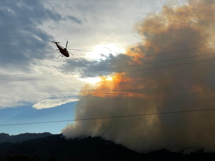
Operations on the Monument Fire near Hayfork | Photo from Inciweb
Community meeting update from Inciweb:
Virtual Community Meeting for Monument and Knob Fires, Sept 12 @ 7PM
Join us live Sunday, September 12, 2021 at 7:00 PM for a Virtual Community Meeting for the Monument and Knob Fires. Watch us live, on both the Shasta-Trinity and Six Rivers Facebook pages. You can also join via Zoom using: Zoom: https://usfs.zoomgov.com/j/1610820265…
• The Meeting ID: 161 082 0265 • Passcode: +tX1=6 • The call-in-number: +1-669-254-5252 Submit questions prior to the meeting at 2021.monument@firenet.gov.
Fire Management will be on hand to respond to questions.
###
Press release from the U.S. Forest Service:
COMMUNITY MEETINGS: Today, there will be two Monument Fire informational gatherings for the communities of Hyampom and Hayfork. The first will be at 11 A.M. at the Hyampom Fire Station (22547 Hyampom Road), and the second will be at 2 P.M. at the Hayfork Park (Community Drive).
MONUMENT FIRE:
Resources: 1,438 personnel, 26 hand crews, 85 engines, 9 helicopters, 29 dozers, 9 water tenders, 15 masticators
Current Situation: The Monument Fire is approximately 208,265 acres and 43 percent contained. Last night due to increased humidity and cooler temperatures, most areas around the fire’s perimeter saw minimal fire activity with the exception of the northwest side, east of Trinity Village. Crews conducted a defensible firing operation along the Denny Road near Dyer Creek towards Bell Creek to stop the advancing fire front.
Today, the priority is the northwest east of Trinity Village and in the southwest near Hayfork. West of Hayfork, crews continue working to execute the existing plan of utilizing the Butter Creek Road to contain the fire. When conditions allow this afternoon, a defensible firing operation will be implemented to remove unburned vegetation between the road and the advancing fire.
On the northwest side, the fire will become more active this morning due to prevailing winds and steep terrain. Crews will continue firing operations along the Denny Road and provide structure defense. A second portable fire-retardant base is being established for helicopters at Burnt Ranch. Helicopters will be able to fill large buckets with retardant, from tanks on the ground, and transport it more quickly to areas on the north side of the fire.
To the north, in the Trinity Alps Wilderness, the fire is currently 5 miles from the River Complex. There is no planned strategy to let the fires grow together. As firefighting resources become available, aggressive action will be taken to contain the fire.
On the fire’s northeast side, crews continue to strengthen the containment line from the East Fork Road up to Backbone Ridge. A finger of the fire crossed over the East Fork North Fork Trinity River and crews continue to work on building a containment line around the active fire. Structure defense engines continue to work in the Canyon Creek area.
WEATHER AND FIRE BEHAVIOR: A more typical weather pattern is expected today as high pressure rebuilds over the area. A west-southwest flow aloft will increase temperatures and lower humidity.
MONUMENT FIRE ROAD CLOSURES AND RESTRICTIONS (Trinity County):
- Denny Road is closed at the intersection of Ziegler Point Road.
- Hyampom Road is closed between Cedar Gulch Road and St. John Road.
- Big Creek Road, Soldier Creek Road, Barker Valley Road, Barker Creek Road, and Carr Creek Road are closed.
- Big French Creek Road and Big Mountain Road are closed.
- A segment of State Route 299 between mile post 7.4 (near Burnt Ranch at Berg Road) and mile post 36.3 (just west of Helena) is open to through traffic and residents on the following schedule: Monday through Sunday, from 7 A.M. to 7 P.M., an escort vehicle leads traffic through the closure every 1.5 hours. Overnight, from 7 P.M. to 7 A.M., the road is open only to residents with proof of address.
MONUMENT FIRE EVACUATIONS (Trinity County): The following information was taken directly from Trinity County Sheriff’s Office Facebook page. Evacuation orders and warnings can be issued or change suddenly; if you have questions about evacuation boundaries, call Trinity County Sheriff’s Office at 530-623-2611.
- Order: All areas along Denny Road northeast from Zeigler Point Road through Denny proper to the Trinity Alps Wilderness boundary
- Order: All areas along Hyampom Road from Grassy Flat Road west to St. John Road. This includes Bar 717 Camp. All areas south of the intersection of FS Road 10/ St. John Road south to Sydney Lane. From Sydney Lane northeast through FS Road 10/ St. John Road to Oak Ridge
- Order: Intersection Tule Creek Road at Jesse Road, south along Tule Creek Road to intersection FS Road 31N31,west on Tule Creek Road/FS Road 10 to FS Road 7, west of FS Road 7 along Tule Creek Rd/FS Road 10 to Oak Ridge of Oakridge to FS Road 3N08. All areas along Tule Creek Road/FS Road 10 through Indian Valley. Roads and areas included are Land Acre Road, Mule Lovers Lane, Buck Gulch, Cow Gulch, and Tule Divide
- Order: All areas along Hyampom Road east of Drinkwater Gulch to Cedar Gulch Road, from Cedar Gulch south to Tule Creek Road at Green Gate Road, including all residences on Turkey Track Road, Doctor Lane, Digger Gulch, Shangri La Lane, Green Gate Road, and McAlexander Road
- Order: All areas along both sides of Hyampom Road between Lucky Jeep Trail and Drinkwater Gulch, including Fox Lane, Drinkwater Gulch, and Phares Lane
- Order: All areas along Hyampom Road between Lucky Jeep Trail and Halfway Ridge
- Order: Helena/East Fork Road, Hobo Gulch Road, Big Mountain Road, and Big French Creek Road
- Warning: All areas in Hawkins Bar and Trinity Village north of State Route 299 between Suzie Q Road and Gray Falls Campground, including Suzie Q Road, Denny Road to Ziegler Point Road, Lone Pine Road, Big Oak Road, China Flat Road, Flame Tree Road, Coon Creek Road, Pony Creek Road, Gray Flat Road, Emerald City Lane, and Ammon Road
- Warning: All areas along Hyampom Road from Cedar Gulch to State Route 3 are under an Evacuation Warning. This includes Circle Drive, Highland Drive, North Vista Lane, Murray Lane and Bean Gulch and North Talco Way.
- Warning: All areas south of Hyampom Road along State Route 3 to Salt Creek Growers. All areas West on Tule Creek Road from State Route 3 to Jesse Lane
- Warning: All areas east of Hyampom Road, both north and south of State Route 3 to Big Creek Road. All areas south of Big Creek Road to Morgan Hill Road/ Coonrod Gulch. From Coonrod Gulch South West through Kingsbury Gulch to State Route 3. This includes all of Hayfork proper
- Warning: Denny Road east from Ziegler Point Road through Denny to the Trinity Alps Wilderness boundary
- Warning: Canyon Creek Road in Junction City
KNOB FIRE:
Resources: 191 personnel, 4 hand crews, 28 engines, 2 dozers, 1 water tenders
Current Situation: The Knob Fire is approximately 2,421 acres and 98 percent contained. On the fire’s northwest perimeter, approximately a quarter-mile section of fire line along Panther Ridge remains the priority. Firefighters will continue to strengthen the fire line on Panther Ridge as well as patrol the fire perimeter, extinguishing any visible hot spots.
KNOB FIRE EVACUATIONS (Humboldt County): The following information was taken directly from Humboldt County Sheriff’s Office website and Humboldt County evacuation map. Evacuation orders or warnings can be issued or change quickly; if you have questions about evacuation boundaries, call Humboldt County Sheriff’s Office at 707-268-2500.
- Warning: All areas east of Brushy Mountain Lookout Road/FS Road 6N08A to the Humboldt/Trinity County Line,south of the Trinity River at Bremer Creek to China Creek
- Warning: All areas east of Boise Creek to the Humboldt/Trinity County Line, south of the Trinity River to Victor Creek
EVACUATION CENTERS: American Red Cross, California Northwest Chapter, 707-832-5480
- Fireman’s Hall Pavilion, 9 Park Street, Fortuna
- First Baptist Church, 1261 Main Street, Weaverville
LOCAL ASSISTANCE CENTER (LAC): A local assistance center will be operating at Veteran’s Memorial Hall (109 Memorial Drive) in Weaverville on Saturday, September 11, from 9 A.M. to 4 P.M.
FOREST CLOSURE: The USDA Forest Service has temporarily closed all National Forests in California. Direct questions to 707-562-9113 or SM.FS.R5inquiries@usda.gov.
CLICK TO MANAGE