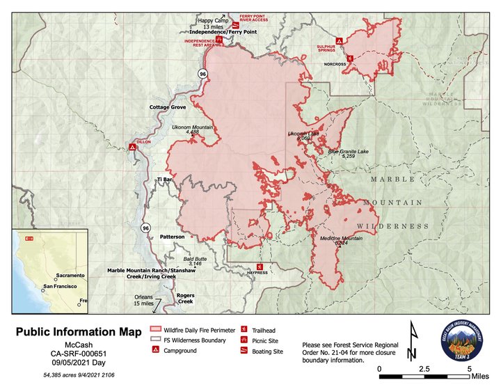
The latest map of the McCash Fire. | USFS
U.S. Forest Service press release:
McCash Fire Grows to 54,385 Acres, 7 Percent Contained
An infrared flight over the McCash Fire showed the fire is 54,385 acres. The fire is 7 percent contained. There are 443 people assigned to the incident.
Great Basin Team 3 will begin the process today of transitioning command of the McCash Fire to Great Basin Team 7, which is also a Type 2 team. The official transfer of command will take place Tuesday at 7 a.m.
Yesterday, firefighters successfully continued a small-scale firing operation to contain the northern edge of the spot fire in the Buckhorn Bear area. They will resume this operation today, weather permitting, working along existing roads and a dozer line west toward Elk Creek Road. Crews will also continue to use a grader and masticators to prepare a contingency line from Frying Pan Ridge to Grider Ridge. Both operations are expected to take about four days to complete.
Several more sections of the control line from Independence Ridge to Johnson Hunting Ground are closer to being declared contained, thanks weeks of hard work by firefighters. The hand line, dozer line and hoses around areas where the fire crossed the control line have held the fire in check. Crews are using dozers and hand tools to improve the Chicken Ladder Road (15N13). The Titus Ridge Road (15N10) is also being improved with dozers and masticators. The improvements are creating additional contingency lines to stop potential fire movement to the east or west, if the fire were to get across the northern line.
The Highway 96 Structure Group has the same assignment today that they had yesterday. They will support operations along the dozer line on Independence Ridge and patrol the highway corridor, including areas west of the highway. The purpose of their patrols is to check for possible spot fires. No spot fires have been detected west of the Klamath River or the highway.
Yesterday, the Elk Creek Structure Group began putting in dozer line and hand line, as well as pumps and hoses, around structures in the Elk Creek area. They will continue this work today. They are also coordinating with local resource advisors to reopen and improve dozer line and hand line from previous fires south of Happy Camp.
Crews working the Patterson and Ti-Bar areas will begin the backhaul process today, removing excess firefighting equipment from areas where it is no longer needed. A dozer working to improve the Iron Phone Road along the southern edge of the fire has reached Black Mountain. A masticator is following behind to help create a southern contingency line inside the 2017 Haypress Fire scar.
Infrared imaging collected during nightly flights is providing firefighters with information about the McCash Fire’s movement in the Marble Mountain Wilderness on the southeast side of the fire. Heavy smoke has grounded all traditional recon flights for days. The fire is still backing slowly down the Wooley Creek drainage. When appropriate resources are available, crews will look for opportunities to fight the fire using minimum impact suppression tactics (MIST) to effectively meet their objectives with the fewest environmental, cultural and social impacts to the wilderness area.
Weather: Hot, dry weather will continue for a couple more days. High temperatures are predicted to be in the 90s with low humidity and wind speeds of 5-7 mph. There is a 25 percent chance of showers or thunderstorms Tuesday, when southerly ridgetop winds are expected to be 10-15 mph with gusts up to 30 mph.
No Drone Zone: A temporary flight restriction (TFR) remains in place over the McCash Fire. Flying a hobbyist drone over a fire puts everyone at risk and hinders firefighting suppression efforts. If you fly, we must ground all aircraft due to the dangers unauthorized drones pose to firefighting aircraft. To find information about the TFR, visit https://tfr.faa.gov/save_pages/detail_1_0033.html. Remember, a TFR also applies to unmanned aircraft systems (UAS) or drones.
Smoke: Smoke from the McCash Fire and neighboring fires in northern California is impacting local communities. For air quality information go to https://fire.airnow.gov or https://bit.ly/SiskiyouWildfireSmoke.
Evacuations: For the most current and accurate evacuation information for Siskiyou County, please visit the Siskiyou County Sheriff’s Office Facebook page at: https://www.facebook.com/SiskiyouCountySheriff or the county evacuation map at https://bit.ly/SiskiyouEvacMap.
All residents are encouraged to sign up for CodeRED Emergency Alert at: https://bit.ly/CodeRedSiskiyou
Road Closures: Road information can be found by calling 1-800-427-7623 or on the Caltrans website https://roads.dot.ca.gov/
Visit the following sites for specific Forest Closure information:
U.S. Forest Service Region 5 https://bit.ly/R5ForestClosures
Six Rivers National Forest https://bit.ly/SRNFNotices
Klamath National Forest https://bit.ly/KNFNotices
For further information about the McCash Fire, please visit the following links: https://inciweb.nwcg.gov/incident/7757/
CLICK TO MANAGE