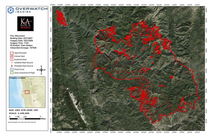
The latest map of the Monument and Knob Fires. | USFS
U.S. Forest Service press release:
MONUMENT FIRE:
Resources: 2,466 personnel, 35 hand crews, 164 engines, 4 helicopters, 45 dozers, 36 water tenders, 15 masticators
Current Situation: The Monument Fire is approximately 185,505 acres and 41% contained. Within the fire perimeter, two areas remain the focus: the north side, which is primarily in the Trinity Alps Wilderness, and the southwest side, which is east of Hyampom and northwest of Hayfork. Suppression efforts are being implemented to protect the Trinity Alps Wilderness, the Trinity Wild and Scenic River, Inventoried Roadless Areas, and endangered species habitat.
Yesterday, the fire progressed downslope toward James Creek and Hyampom Road at a moderate pace. It reached Hyampom Road at a couple points east of Nine-Mile Bridge, where crews were positioned to hold the fire. However, weather conditions worsened and winds increased, causing the fire to spot in several locations south of Hyampom Road. Firefighters were able to suppress and contain most of the spot fires, but one became established south of Nine-Mile Bridge and is estimated to be around 300 acres.
Today, the highest priority will be to construct a containment line around the 300-acre spot fire south of Nine-Mile Bridge and to protect any structures south of Hyampom Road. Crews will also continue to work on Pattison Ridge securing containment lines and conducting firing operations toward Hayfork Creek.
A mobile fire-retardant base has been established and is available to help fire suppression efforts along the southwest fire perimeter. As the smoke lifts, helicopters will be utilized to drop retardant and water in active fire areas.
On the northern perimeter, gusty winds are predicted this afternoon which will increase fire activity in the area below Thurston Peak in the Trinity Alps Wilderness. Firefighters will continue to work on improving contingency lines along Backbone Ridge. The North Fork Trinity River is located in a deep drainage, sheltered from the wind, which has moderated fire activity. The fire had not crossed to the east side of the river. Containment line elsewhere around the fire perimeter continues to be monitored and patrolled.
KNOB FIRE: Resources: 229 personnel, 7 hand crews, 30 engines, 2 dozers, 2 water tenders
Current Situation: The Knob Fire is approximately 2,414 acres and 89% contained. Last night fire behavior was minimal, with no spotting outside of the fire perimeter. Today, crews will continue to work on the north side strengthening and improving containment lines and extinguishing any hotspots within 300 feet of the perimeter of the fire.
WEATHER AND FIRE BEHAVIOR: Poor overnight humidity recovery and extremely dry, hot weather will persist through today. These conditions, combined with today’s gusty winds, have led incident meteorologists to issue a local Red Flag Warning that is in effect from 10 a.m. to 8 p.m. Incident fire behavior analysts have cautioned fire managers and crews that they will see atmospheric instability; hot, dry weather; winds aligning with topography; and dry vegetation, which will result in moderate to extreme fire behavior. Firefighters have been cautioned to expect long-range spotting and crown fires, particularly on the fire’s north side.
MONUMENT FIRE ROAD CLOSURES AND RESTRICTIONS (Trinity County):
- East of Hyampom: Hyampom Road between Lucky Jeep Trail and Halfway Ridge
- Northeast of Hayfork: Big Creek Road, Barker Valley Road, Barker Creek Road, Carr Creek Road
- West of Junction City: Big French Creek Road, Big Mountain Road, Soldier Creek Road
- A segment of State Route 299 between mile post 7.4 (near Burnt Ranch at Berg Road) and mile post 36.3 (just west of Helena) is open to through traffic and residents on the following schedule: Monday through Sunday, from 7 a.m. to 7 p.m., an escort vehicle leads traffic through the closure every 1.5 hours. Overnight, from 7 p.m. to 7 a.m., the road is open only to residents with proof of address.
KNOB FIRE ROAD CLOSURES (Humboldt County):
- China Creek Road at Hodgson Road
- Friday Ridge Road
- Panther Road
MONUMENT FIRE EVACUATIONS (Trinity County): This information can change at any time, and residents are advised to monitor the Trinity County Sheriff’s Office Facebook page for the latest information at Trinity County Sheriff’s Office Facebook, or call 530-623-2611.
Issued September 6th at 8 p.m.
- Order: All areas along both sides of Hyampom Road between Lucky Jeep Trail and Drink Water Gulch, including Fox Lane, Drink Water Gulch, and Phares Lane
- Order: All areas along Hyampom Road between Lucky Jeep Trail and Halfway Ridge
- Order: Helena/East Fork Road, Hobo Gulch Road, Big Mountain Road, and Big French Creek Road.
Issued September 6th at 8 p.m.
- Warning: All areas along Hyampom Road east of Drink Water Gulch to Digger Gulch and South to Tule Creek Road and Green Gate Road, including Turkey Track Road, Doctor Lane, Digger Gulch, Shangri La Lane, Green Gate Road, McAlexander Road
- Warning: Denny Road east from Ziegler Point Road through Denny to the Trinity Alps Wilderness Area boundary
- Warning: Section of Campbell Ridge Road and Woods Lane near the Trinity River along the Humboldt/Trinity County line
- Warning: Canyon Creek Road in Junction City KNOB FIRE EVACUATIONS (Humboldt County): This information can change at any time, and residents are advised to monitor the Humboldt County Sheriff’s Office webpage for the latest information at humboldtsheriff.org, tinyurl.com/humcoevacmap, or call 707-268-2500.
- Order: Areas east of Brushy Mountain Lookout Road/FS Road 6N08A to State Route 299, south of Victor Creek to China Creek
- Order: Areas east of Brushy Mountain Lookout Road/FS Road 6N08A to the eastern perimeter of the Knob Fire south of China Creek to Friday Ridge Road
- Order: Areas east of Brushy Mountain Lookout Road/FS 6N08A to the South Fork Trinity River, south of Friday Ridge Road to the end of the FS Road 6N20
- Warning: Areas of Boise Creek to the Humboldt/Trinity County line, south of the Trinity River to Victor Creek
- Warning: Areas east of State Route 299 to the Humboldt/Trinity County line, south of Victor Creek to China Creek
- Warning: Areas east of the Knob Fire perimeter to the Humboldt/Trinity County line, south of China Creek to Friday Ridge Road
EVACUATION CENTERS:
American Red Cross, California Northwest Chapter, 707-832-5480
- McKinleyville Seventh Day Adventist, 1200 Central Avenue, McKinleyville
- Fireman’s Hall Pavilion, 9 Park Street, Fortuna
FOREST CLOSURE: The USDA Forest Service has temporarily closed all National Forests in California. Direct questions to 707-562-9113 or SM.FS.R5inquiries@usda.gov.
CLICK TO MANAGE