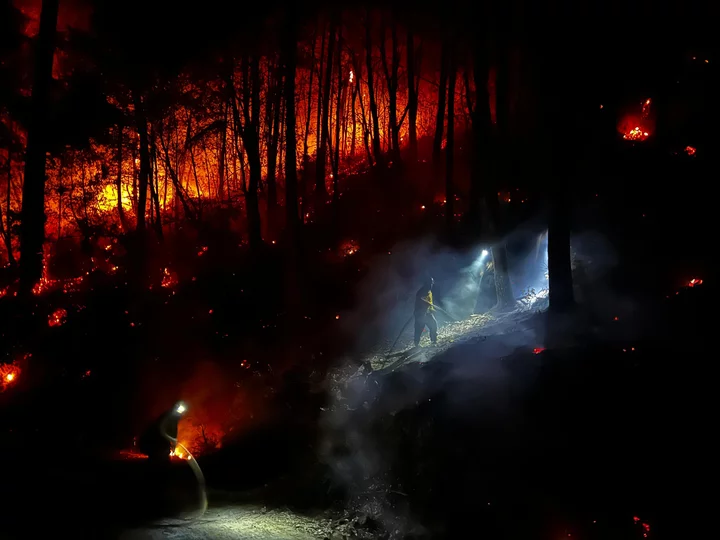
Hand crews using Drip Torches as part of defensive burning operation between Lone Pine Ridge and Horse Linto Creek. Photo: CAIIMT14 via Inciweb
###
Press release from the unified command of the Six Rivers Lightning Fires:
The Six Rivers Lightning Complex remains in unified command with California Interagency Incident Management Team 15, California Highway Patrol, Trinity County Sheriff, and Humboldt County Sheriff. The Six Rivers Lightning Complex is currently 40,995 acres with 64% containment and 1,521 personnel assigned to the incident.
CURRENT SITUATION
Wildland firefighters will continue efforts to increase containment on the remaining two fires of the Six Rivers Lightning Complex. The Ammon fire has experience minimal growth over the past week, however, interior smoldering of ground fuels will persist with limited threats to control lines. The Campbell fire also remained within the control lines yesterday.
Today, firefighters will focus efforts on holding and improving the control lines near Cedar Creek on the north end of the fire and above the communities of Trinity Village and Hawkins Bar near the southeastern perimeter.
A National Infrared Operations fixed wing aircraft conducted an overnight flight to identify the remaining pockets of heat across the fire area. Today, ground resources will target those hotspots to limit the potential for future spread. Fire resources will continue tactical patrols due to the steep terrain and abundance of burning dead ground fuel, to lessen the threat of hot material rolling across the mid-slope roads causing spot fires outside of the control lines along all the perimeters.
Most of the current smoke production is being generated from several large, unburned pockets of vegetation well within the perimeter of the Campbell fire. The northeast winds in the early morning may bring smoke into communities West and South of the fire area. The overall decrease in fire behavior should improve air quality in the coming days.
Check out the Six Rivers Smoke Outlook for more information: https://outlooks.wildlandfiresmoke.net/outlook/65384a03.
ROAD CLOSURES
Due to a large presence of fire personnel and machinery working to build containment lines for the Ammon Fire, residents are asked to limit travel on Titlow Hill Road/Route 1 in zones HUM-E052 and HUM-E062 to essential traffic only. Residents may still use roads to travel out of evacuation order zones:
The following roads into evacuation zones have been closed.
- Forest Route 7n15 at Six Rivers Forest BoundaryThe following roads are restricted to local traffic only:
- Horse Linto Creek Road at Saddle Lane (Open to residents only)
- 6N06 Sandy Bar (Route 6)
- Titlow Hill Road (Route 1) at Horse Mountain Botanical AreaState Route 299 remains open to through traffic. Residents are encouraged to visit http://quickmap.dot.ca.gov/ to check for state highway closures.
FOREST CLOSURES
Forest order NO. 22-10-06 Six Rivers Lightning Complex is currently in place, which includes river access at Kimtu Park.To view this closure and map, please visit: https://www.fs.usda.gov/alerts/srnf/alerts-notices
EVACUATION UPDATES
For the latest evacuation information go to Humboldt County Office of Emergency Services (https://humboldtgov.org/2383/Current-Emergencies) or Trinity County Office of Emergency Services (https://www.trinitycounty.org/OES). For an interactive map of evacuation zones visit: https://community.zonehaven.com/. To sign up for alerts: www.humboldtgov.org/alerts.
HUMBOLDT COUNTY EVACUATION WARNINGS remain in effect for zones:
HUM-E032: NORTH OF Forest Route 7n02, SOUTH OF Hoopa Valley Reservation, EAST OF Trinity River, WEST OF County Line
HUM-E061-A: NORTH OF Forest Route 7n15, SOUTH OF Forest Route 7n15, EAST OF Seeley McIntosh Road, Campbell Ridge Road, WEST OF Forest Route 7n15
HUM-E058: NORTH OF Forest Route 7n15, SOUTH OF Horse Linto Creek Road, EAST OF Peach Tree Lane, WEST OF Coon Creek Rd, Forest Route 7n15
TRINITY COUNTY EVACUATION WARNINGS:
ZONE 480: This zone includes all areas north of the Denny Road from the intersection of the Denny Road and Wallen Ranch Road, FS Road 7N04 through Hawkins Creek north to the County Line. Wallen Ranch Road, FS Road 7N04 and any spur roads off FS Road 7N04 will be closed to public access. The temporary Evacuation point will be at the Wayside Chapel located at 1020 State Route 299 in Willow Creek, CA.
ZONE 481: This zone includes areas along the Denny Road North and North of Denny saddle through the Happy Camp Mountain Area including Bell Creek. Areas southeast of Happy Camp Mountain through Dryer Creek and Bell Flat. Denny Road will remain open.
Zone 482 - Suzy Q Road and all roads off of Suzy Q Road
An EVACUATION WARNING remains in effect for Campbell Ridge Road from Salyer Heights to Seeley McIntosh Road. Salyer area, including Galaxy Road, and the area of Ziegler Point Road/Forest Service Road 7N04 have been reduced to an Evacuation Warning.
ANIMAL EVACUATION CENTER Hoopa Rodeo Grounds 1767 Pine Creek Rd., Hoopa, CA 95546 Phone: (707) 492-2851

CLICK TO MANAGE