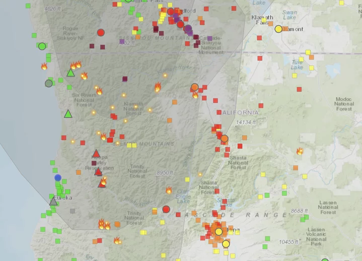
Screenshot of smoke map via airnow.gov.
###
State agencies are reporting “unhealthy” to “hazardous” air quality conditions throughout the Hoopa Valley, the result of multiple fires burning inland.
Residents in the area of Bald Hill on the Hoopa Valley Reservation, north of the Lone Pine Fire, are experiencing air quality conditions in the 600 range – twice the threshold for “hazardous” conditions, according to the U.S. Air Quality Index.
The Hoopa Valley Office of Emergency Services has advised communities throughout the Hoopa Valley to avoid all outdoor physical activity. Sensitive groups – including people with heart or lung disease, older adults, children, and pregnant people – should stay indoors in a place with clean indoor air and keep activity levels light.
Clean air shelters can be found at the following locations:
- Willow Creek Open Door Clinic, 38883 Highway 299, Willow Creek. Open during business hours.
- Willow Creek Library, 39 Mayfair Street, Willow Creek. Open during business hours.
- Dreamquest (Youth), 100 Country Club Drive, Willow Creek. Open during business hours.
The perimeter of the Lone Pine Fire as of Friday morning | Graphic: Andrew Goff
# # #
As of this writing, the Lone Pine Fire, located south of Hoopa, has consumed 500 acres and is five percent contained. There are no structures currently threatened by the fire.
“Crews made progress yesterday constructing handline down the ridge to the river, they were also successful containing multiple spot fires that occurred throughout the day,” according to a Friday morning fire update. “The fire is burning in extremely steep and rugged terrain which is creating some access challenges.”
There is an evacuation advisory for zone HIA-E014-B, north of the Bigfoot Scenic Byway, south of Tish Tang Road and east of Tish Tang Road. There are no mandatory evacuations in place at this time.
###
Six Rivers National Forest and Hoopa Tribe Joint News Release:
Pearch Fire was reported the night of August 16, it is burning in the Pearch Creek watershed in Orleans. Yesterday’s priority was assessing access into the fire by utilizing prior fire dozer, handline and structure protection assessment in the communities of Pearch Creek and Red Cap. The local Orleans Crew 20 wildland fire module successfully identified and protected critical and historical infrastructure using structure wrap to protect historic Orleans Mountain Lookout and also, clear vegetation away from essential radio and phone communication repeater towers. Today crews will continue similar objectives as of yesterday, assessing access into the fire area, structure and critical infrastructure protection assessment.
Bluff Complex consists of 5 separate fires located near the Bluff Creek area north of Mosquito Lake. The total acreage for the complex is approximately 350 acres with 0% containment. With limited resource capacity fires are being monitored and assessed.
The 3-1 to 3-6 Fires (referred to by some sources as the Pilot Fire) consists of six separate fires named 3-1; 3-2; 3-3; 3-4; 3-5; 3-6. These fires are burning in Humboldt County, just northwest of the Trinity County Line and Forest Route 1 near Blake Mountain on state and forest service lands. The total acreage for these fires is over 500 acres with 0% containment. Yesterday, the fire received wetting rain throughout the early and mid-morning. Inversion moderated fire behavior in the morning thru mid-afternoon, when the inversion lifted in the late afternoon, fire behavior increased. Today, engines and equipment will continue suppression efforts.
Lone Pine is approximately 500 acres with 5% containment. The fire is located south of Hoopa, in the Horse Linto Creek drainage east of the Trinity River across the river between the Tish Tang Campground and Sugar Bowl Ranch. Crews made progress yesterday constructing handline down the ridge to the river, they were also successful containing multiple spot fires that occurred throughout the day. The fire is burning in extremely steep and rugged terrain which is creating some access challenges. There are no structures threatened. Adverse weather conditions can change fire behavior and ask the public to remain alert. Today, firefighters will continue to create handline and intent to contain fire in the smallest footprint as possible.
Evacuation Advisory: Issued by the Hoopa Office of Emergency Services for zone HIA-E014-B. This zone is north of the Bigfoot Scenic Byway; south of Tish Tang Road; east of Tish Tang Road. This ADVISORY is a precautionary notice designed to give residents time to prepare for a possible evacuation. Potential for evacuation warning if fire crosses Tish Tang Creek.
There are NO EVACUATIONS for any of the fires listed on this update. More information will be provided if fire conditions change. To register for alert notifications and view advisory location map visit www.protect.genasys.com or download the Genasys Protect App.
Weather Northwesterly flow is pushing some cloud cover over the area and smoke to the west. Through the day, skies will clear and some smoke will lift. Expecting warm temperatures in the 90s once again, with dry humidity. If skies do not clear though, temperatures will be much more moderate. A 10% chance of thunderstorms remains tonight, but generally will stay east over Shasta-Trinity National Forest. Cannot rule out a stray shower or two. Winds continue to be terrain driven in the afternoon, with weak offshore flow overnight.

CLICK TO MANAGE