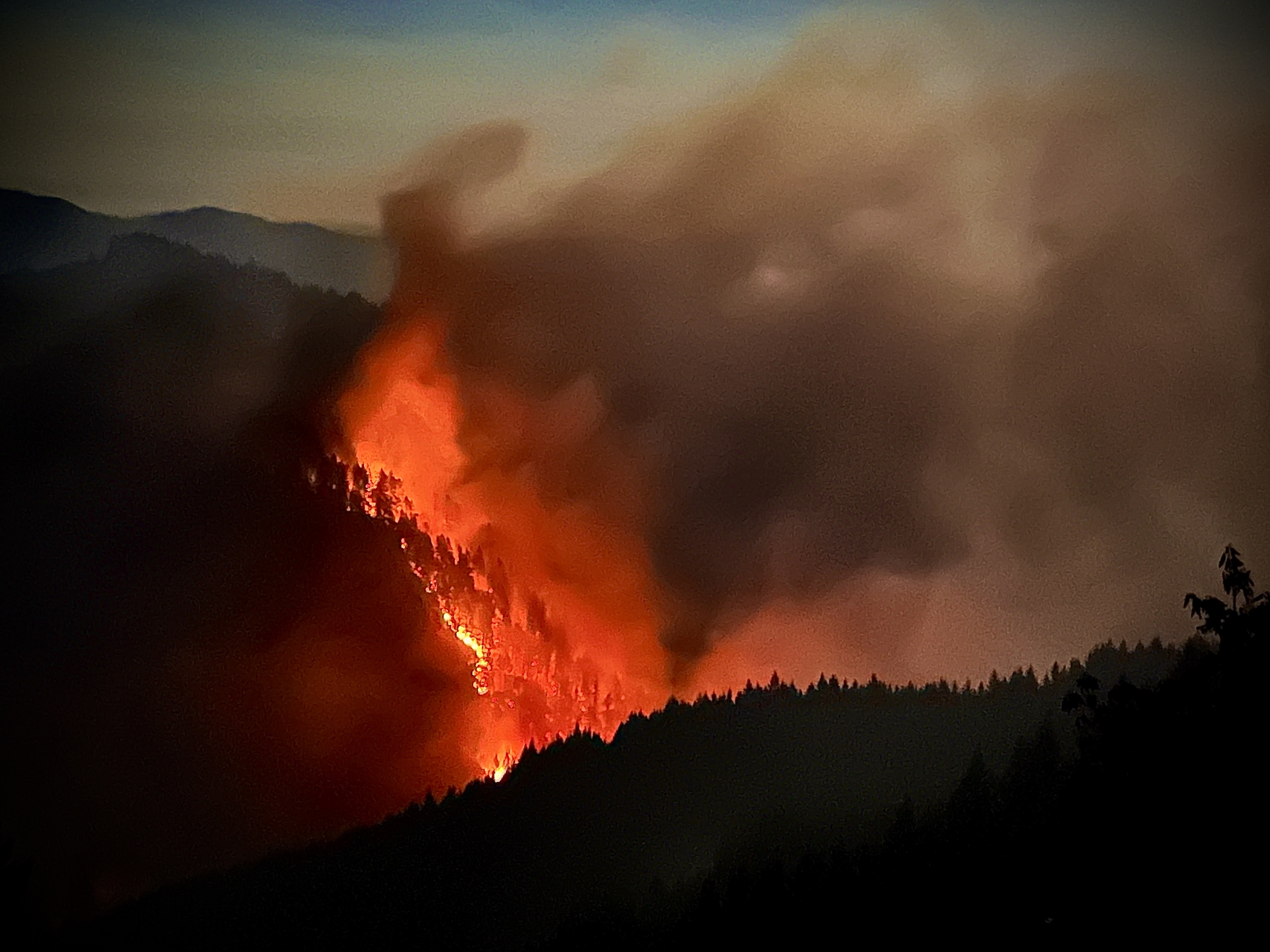
Video and imagery via Hill Fire Incident Command Flickr.
###
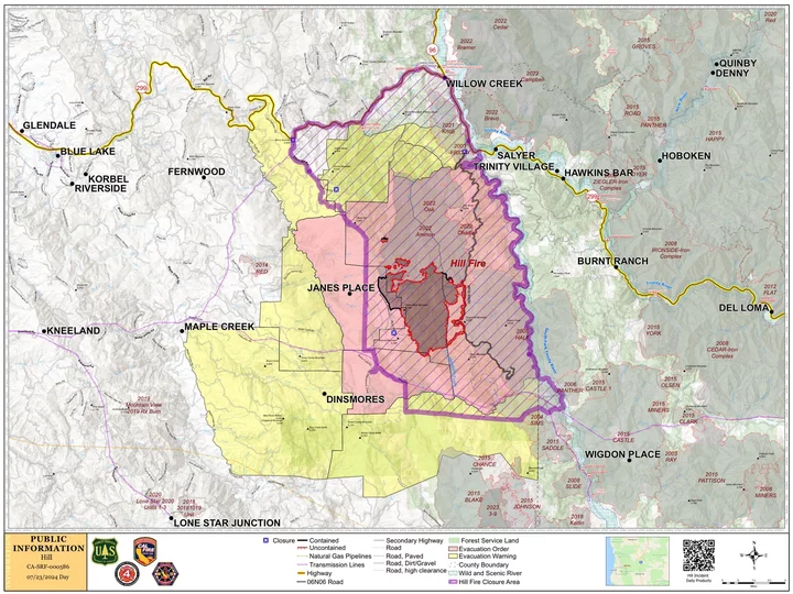
As of Tuesday morning, the Hill Fire burning 11 miles south of Willow Creek is listed at 7,074 acres with eight percent containment.
Favorable weather patterns earlier this week helped fire crews “gain good positioning” on the fire and expand containment lines, according to the Hill Fire Incident Command team. However, fire activity is expected to increase over the coming days with rising temperatures and lower relative humidity.
“Crews will be monitoring the west side and patrolling for any hot spots,” according to this morning’s update. “On the east side, crews will focus on suppressing any remaining hot spots as well as continued tactical firing operations. … Structure defense teams remain active to identify potential risks and implement mitigation strategies as part of the larger contingency plan.”
Residents in zones HUM-E076-A, HUM-E077-A, HUM-E077-B and HUM-E077-C are still under an evacuation order. Residents currently under an Evacuation warning should be ready to leave at a moment’s notice if conditions deteriorate. Find your evacuation zone at this link.
The Incident Command team will host a community meeting on Wednesday at 7 p.m. at the Willow Creek Bible Church. The meeting will be streamed live on the 2024 Hill Fire Facebook Page.
The following additional information comes from the Hill Fire Incident Command Team:
CURRENT SITUATION:
Favorable weather patterns during the early part of the week allowed firefighters to gain good positioning on the Hill
Fire and increase containment to 8%. Tactical firing along Forest Road 6N06 on the eastern boundary of the fire has
enabled crews to create as much as 200 feet of depth between the fireline and the primary fire expanding the fire
footprint 7074 acres. This strategic approach continued with unmanned aircraft assisting in the evening, further
extending the depth.
Crews have successfully connected these firing operations with a combination of dozer and hand lines connecting to
Mosquito Creek and the western edge of the fire. Mop-up operations were continued to address remaining hotspots
along the fire’s perimeter. Control lines in the north and west continued to be monitored, and hotspots eliminated
overnight.
Map of Hill Fire Boundaries. Click to enlarge.
With rising temperatures and lower relative humidity expected during the next few days, these proactive operations
have positioned crews ahead of the weather change. Structure defense teams remain active to identify potential risks
and implement mitigation strategies as part of the larger contingency plan.
Today, with the drier weather and hotter temperatures, fire activity is expected to increase, allowing for the ignition of
some areas within the fire perimeter that still have unburned fuel. Crews will be monitoring the west side and
patrolling for any hot spots. On the east side, crews will focus on suppressing any remaining hot spots as well as
continued tactical firing operations.
WEATHER:
High pressure will peak today with heat approaching 100 and relative humidity near 20 percent in clear valley. Smoke,
especially on the east side will generally moderate conditions, but still expect to be hotter and drier than yesterday.
Increased lift will help disperse smoke but weak and battling winds switching from south to north will not be favorable
to efficient smoke transport. Compressing inversion will bring poorer overnight recoveries to mid-elevations. Despite
high pressure at the surface, instability and moisture aloft will bring a slight chance of dry thunderstorms by early
Wednesday morning.
EVACUATIONS:
Evacuation order and warnings remain in effect. For current updates on evacuations, visit
https://www.facebook.com/HumboldtSheriff and https://humboldtgov.org/2383/Current-Emergencies.
Conditions are subject to change at any time, visit https://protect.genasys.com/search for a full zone description.
Sign up for Humboldt Alert emergency notifications at https://humboldtgov.org/2014/Emergency-Notifications
CLOSURES:
Forest Closure Order currently in effect for the area impacted by the Hill Fire. It is temporarily prohibited to be on
any national forest system land, trail, or road within the closure area. To view the closure order and map of closure
area visit the following link www.fs.usda.gov/Internet/FSE_DOCUMENTS/fseprd1191963.pdf.
Road closures are currently in place on Friday Ridge Rd. at Forest Service Route 6N06, Friday Ridge Rd. at Forest
Route 5N01 and Friday Fridge Rd. at Forest Route 5N04. For updated road closure information,
visit protect.genasys.com or humboldtsheriff.org/emergency.
FIRE RESTRICTIONS:
Forest fire restrictions also went into effect on July 12th
. Campfires and stove fires are restricted to those developed
areas listed in the forest order located at https://www.fs.usda.gov/Internet/FSE_DOCUMENTS/fseprd1188610.pdf.
Smoking, welding, and operating an internal combustion engine also have restrictions in place


CLICK TO MANAGE