These maps really are very attractive, and — if you’re partial to that sort of thing — paralyzingly scary. Download them all.
Remember: There’ll be a test of the local tsunami warning system between 11 a.m. and noon Wednesday. Listen to The Point’s interview with chief local seismologist Lori Dengler last week for more info.
Press release from the Redwood Tsunami Work Group follows.
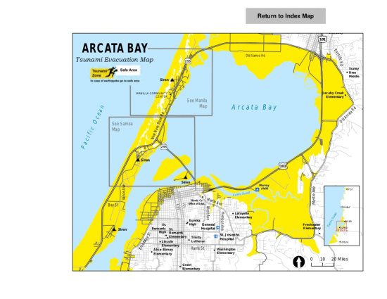
Fourteen new tsunami zone maps are now available for Humboldt County. These maps, prepared by members of the Redwood Coast Tsunami Work Group working with the Humboldt County Sheriff’s Office - Office of Emergency Services, show areas that may be at tsunami risk in Humboldt County. These maps are based on the biggest event and worst case tsunami likely to hit our area, a tsunami caused by a magnitude 9 earthquake on the Cascadia subduction zone.
In most of the County, the boundaries between the white safe areas and yellow tsunami zones shown on the maps are marked by Entering and Leaving Tsunami Zone signs. We urge people who live, work, or play in a tsunami zone to identify the location of those signs and develop a plan on how best to get to a safe area. If a great earthquake occurs nearby, the first tsunami surges could arrive in as little as ten minutes and there will be no time for sirens to sound or other warning messages to be sent out. Earthquake shaking that lasts twenty seconds or longer is your warning. DROP, COVER, and HOLD ON to protect yourself during the shaking. Drop down to the ground, take cover under a sturdy table or desk if one is nearby, and hold on to it. If you are in the yellow area, evacuate by foot as soon as it is safe for you move. If you are in the white area, you are safer staying where you are and sheltering in place. Use the map to plan a safe evacuation route in advance. Practice evacuating so that you and your family know what to do during a real tsunami. Remember — go on foot. Roads may be impassable.
The maps were developed by using information from the Relative Tsunami Hazard Maps produced by Humboldt State University and tsunami inundation mapping by the California Geological Survey and the California Emergency Management Agency. They incorporate the best currently available information and may be changed or updated as additional scientific information becomes available. The maps are intended to support tsunami evacuation planning and should not be used for any other purposes. They do not represent how far an actual tsunami may penetrate inland – but show safe areas and areas that may be at risk delineated by easy-to-recognize geographic landmarks such as streets and roads. They include no information about the probability of a tsunami hitting our area and do not reflect how an actual tsunami may impact the region.
The new maps can be viewed and downloaded here.
A new set of tsunami brochures that will include the 14 new maps will soon be available.
More information on how to prepare for earthquakes and tsunamis is available in the magazine Living on Shaky Ground: How to Survive Earthquakes and Tsunamis in Northern California. Copies are available online at www.humboldt.edu/shakyground or from the Humboldt State University Geology Department, (707) 826-3931
Questions and Answers
Do the maps take into account lessons from the Japan tsunami?
The most important lesson from Japan is to make sure you plan for the largest possible earthquake and tsunami likely to affect your coast. Japan planned for a tsunami produced by a magnitude 7.5 to 8 earthquake and the March 11, 2011 earthquake was a magnitude 9. The Humboldt maps are based on a tsunami that would be produced by a magnitude 9 earthquake just off our coast. Scientists are still pouring over the data from Japan – and as more information becomes available, it is possible the maps will need further adjustments.
How much have the maps changed since the last versions of the map?
The main change from the last version is the addition of more landmarks such as schools, hospitals and street names. There has been very little change in the evacuation area.
How different is the map if a tsunami comes from Alaska, or Chile or somewhere else in the Pacific?
The maps don’t show how far the water will flood our coastline from any specific tsunami whether it comes from nearby or far away. They do show areas that are safe from even the largest tsunami to impact our area and areas where you might be at risk.
Are the maps likely to change?
Tsunami science is a relative young discipline and we learn new information from every event. We also learn new things about how people respond to information and how best to present tsunami hazard data. These maps reflect the best available information that we have right now. If new information becomes available, the maps will be revised as appropriate.
There aren’t any evacuation routes on the maps so how will I know how to get to a safe area?
In much of Humboldt County, there are many ways to get from the tsunami zones to the safe area. Only communities where there is a single designated evacuation site such as Samoa and King Salmon have posted evacuation route signs. In most communities, there are many ways to get to the closest safe area and designating a single evacuation route would make no sense. Use the map to plan which route works best for you. Then practice it with your family and neighbors so that everyone in your household, neighborhood or workplace knows what to do and where to go.How high will the water be at my house, workplace or other location?
These maps don’t show the water height at any location. This is impossible to predict at a particular site. There are so many factors that can influence water height such as the tides, storm conditions and the characteristics of the earthquake or other source that caused the tsunami. The important thing to remember is that white zones on the map are safe. If you are in a white area, you do not need to evacuate. The yellow zones may be at risk. We don’t know exactly how high the water will be in any particular tsunami, but to ensure your safety, evacuate to the white area as soon as you can after feeling an earthquake that lasts a long time.
CLICK TO MANAGE