Orleans Complex Fire Burns 3,200 Acres, is 7 Percent Contained
U.S. Forest Service press release:
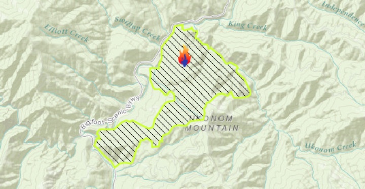
EUREKA, California, August 6, 2017 – The total size of the Orleans Complex is currently 3961 acres. Containment on the complex is currently at 7%. The East Zone of the complex includes the Ukonom
Fire at 3200 acres, the Burney Fire at 513 acres, and the Frank Fire at 13 acres.
The fire behavior in
the timber has been generally low with minimal activity in the form of backing, creeping and flanking.
Firefighters continue to make good progress. There are crews assigned to clean up along Highway 96
and they continue watching for rolling materials falling on to the road. Crews are using existing roads,
ridges and strategic firing to establish control lines on the southern perimeter of the fire.
The West Zone of the complex consists of six fires burning in or near the Siskiyou Wilderness. The
Forks Fire and the Little Fire have the only observed activity. The Forks is the largest at 230 acres,
while the Little remains at three acres. The fires are in a recently burned area that left numerous snags
and heavy fuels, creating hazardous situations for firefighters.
Crews are using a confinement strategy
focused on existing roads and fire lines to reduce the hazards for firefighters.
Cooperators on the incident include representatives from the Karuk and Yurok Tribes.
An important aspect of managing an incident is the Geographic Information System (GIS) team that
prepares all the maps for the incident. They start with the collection of data from Air Operations and
“boots on the ground”. The information is then combined into a system of layers to produce the
mapping products. The data that is collected is saved for future use and updated periodically. The
personnel that work in the GIS unit must meet national standards to be qualified. Maps can vary in size
from small (8.5 by 11 inches) to extremely large (15 by 20 feet is the biggest map this team has ever
printed). On this incident, they have created and keep updated 21 different products, including
operations, information, transportation and medical evacuation maps.
A portion of the Happy Camp Ranger District in the vicinity of the Ukonom Fire was closed to public
entry for the duration of the fire to protect people from the risks associated with an active wildfire. The
closure stretches from the east bank of the Klamath River east to the Independence Creek Road and
includes Ukonom Creek. Please review Klamath National Forest, Emergency Closure order number
17-05-797 for complete details at https://inciweb.nwcg.gov/incident/article/5433/37176/.
Drivers are asked to use caution and slow down when traveling between Somes Bar and Happy Camp
on Highway 96 due to heavy fire traffic and firefighters working along the road. There are one-way
traffic controls in place between Persidio Bar and Dillon Creek.
The Six Rivers National Forest remains under fire restrictions. Details about these restrictions can be
found on the Forest Service website at www.fs.usda.gov/smf. For more information, air quality and
smoke forecasts, maps and photographs, visit the Orleans Complex Inciweb site at
https://inciweb.nwcg.gov/incident/5430/.
CLICK TO MANAGE