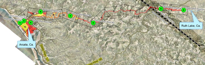
RUTH’S MARCH TO THE SEA This map shows the 80 mile route the river takes from R.W. Matthews Dam to the ocean. The green dots are observation points where emergency personnel would be stationed to report on the wall of water. From HBMWD
###
Note: This is a revised version of an article which first appeared in the Union in June 2015.
###
Emergency personnel are planning for a highly
unlikely but nightmarish scenario – the failure of the R.W.
Matthews Dam, the earthen structure that holds back Ruth Lake.
Should the 150-foot-tall dam fail in an earthquake, major storm or other disaster or terrorist attack, more than 48,000 acre feet of water could come rushing down the Mad River watershed, destroying neighborhoods, wiping out bridges and leaving a massive swath of destruction.
Even though Arcata is about 80 miles downstream from Ruth Lake and in an entirely different county – seemingly a world way – the city wouldn’t escape Ruth’s wrath.
Under the worst-case scenario – the dam bursting during a major rainstorm – the area around Mad River Community Hospital would be under two to four feet of rushing water.
The isolated, rural upstream gorges would encounter a wall of water 20, 30 and even 100 feet high.
Portions of Blue Lake could be washed away. Blue Lake City Hall would be under five to six feet of water, according to computer models from the Humboldt Bay Municipal Water District (HBMWD), which owns the dam.
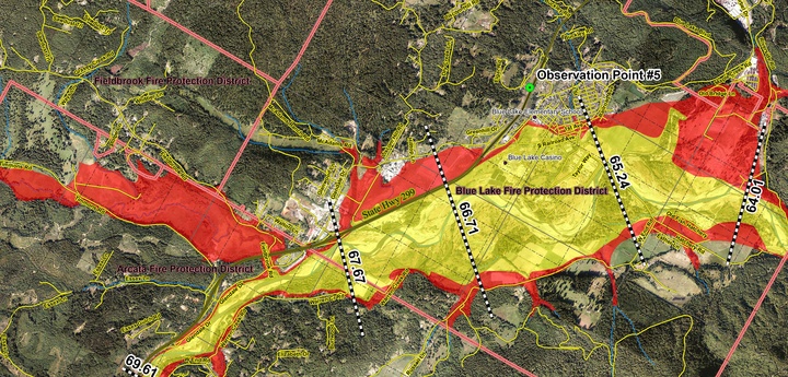
SWATH OF DESTRUCTION The inundation maps show the areas that would be flooded if the dam at Ruth Lake were to fail. This is the map for Blue Lake. The yellow areas show the flooding on a sunny day when river levels are low. Under a worst-case scenario,with river levels similar to the flood of 1964, the areas in both yellow and in red would be flooded. Graphics courtesy HBMWD.
Could this happen?
According to the HBMWD’s Emergency Response Plan, a cataclysmic dam break is “highly unlikely,” but not impossible.
There are several different scenarios that could potentially result in the failure of the R.W. Matthews dam, an earthen structure built in 1962.
One possibility is a giant earthquake. Another is a terrorist attack. Or there could be a massive rain storm that quickly fills the lake beyond the capacity of the spillway to release water downstream.
The water could top the dam and erode the base on the downstream side until the entire dam gives way. Although this is theoretically possible, it’s worth noting that the dam survived the infamous flood of 1964, which was almost biblical in proportions.
Although such a failure is unlikely, the Humboldt County Office of Emergency Services (OES) and HBMWD are working with other agencies and developing plans on how to respond.
Wall of water
The HBMWD has prepared what it calls “enhanced inundation maps” that show where Ruth Lake’s water would go and how high it would be. The maps were created using computer modeling of two different scenarios. One is a “sunny day” scenario. The other is based on a worst-case scenario, with flood levels similar to the great flood of 1964.
Under the worst-case scenario, a massive wall of water would sweep through the Maple Creek area about four hours after the dam failure 50 miles up stream.
About an hour and a half later, a wall of water would wash over Korbel. By the time the water reaches Blue Lake – about five and a half hours after the dam break – the water would be about six feet tall at Blue Lake City Hall. Although this is the worst case scenario, the “sunny day” scenario isn’t much better, with the water about five feet tall.
Valley West would start seeing water about seven hours after the dam break, with the peak flow 11 hours after the failure. The entire area would be covered in two to four feet of fast-moving water filled with logs, snags and other debris that would pose hazards to people and property .
Water levels would go down as the great deluge spread out over the Arcata Bottom, South G Street and other low-lying areas as the water eventually empties into the bay and ocean.
McKinleyville, which sits atop a bluff, would be spared, with only the bottom land along the Mad River inundated.
Among the key facilities that would be destroyed or heavily damaged in the disaster is Mad River Community Hospital, which would be covered in two to four feet of water.
This was noted at a June 18, 2015 district meeting by HBMWD Boardmember Aldaron Laird. “Essentially, we have one hospital that’s going to be shut down, and where are they going to move all those patients? To the other hospital [St. Joseph Hospital in Eureka] And if we have casualties, they’re going to go to that hospital, which is now overwhelmed with patients,” Laird said.
Given the immensity of the potential disaster, planners are focused on getting people away from the wall of water.
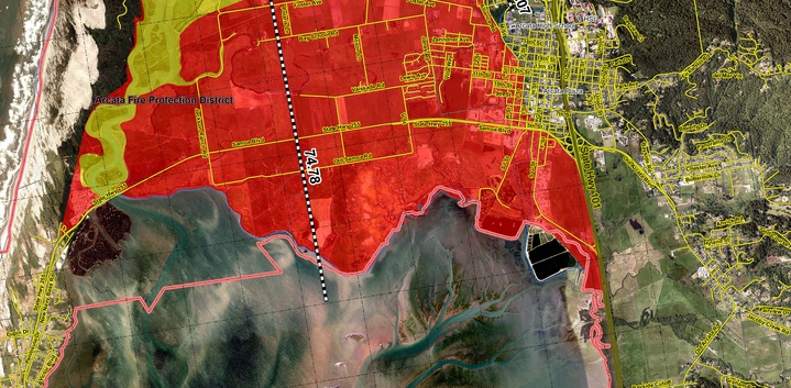
SWATH OF DESTRUCTION: The inundation map for Arcata.
‘Keep them breathing’
Dan Larkin, a retired OES manager who is providing project support, gave a presentation to the HBMWD Board of Directors at its meeting June 18, 2015 about a draft plan on how the county would respond to a dam break.
The plan isn’t ready for public release, but Larkin gave the board main gist of the document – get people out of the way of the water and do so as quickly as possible.
“One of the primary response elements is time. We cannot waste it,” Larkin said. “That wall of water is coming towards us and every second and minute that is wasted hits us on the other end.”
“We must ensure the orderly movement of people. Nothing else matters,” Larkin said.
“During the process, there are a lot of things we don’t care about. I don’t care if people are cold or wet, if they’re hungry or inconvenienced. I don’t care. All I care is getting them out of the way of the water,” Larkin said.
“If you’re caught in the water, you’re essentially dead,” Larkin said.
Retiring HBMWD Manager Carol Rische pointed out at the meeting that it’s not just water that would be coming downstream. There would also be substantial debris.
The plan, Larkin said, is focused on getting people out of the way of this deadly wall of water. After they’re on safe ground, then other plans could be implemented to take care of people’s needs. “We deal with those other issues later.”
The responsibility for informing people that the dam is failing falls on the dam’s owner, the HBMWD, which is the wholesale water supplier to McKinleyville, Arcata, Blue Lake, Eureka, Manila and the Humboldt Community Services District.
The HBMWD has personnel working at and monitoring the dam. In the event of a dam failure, they would notify various agencies about the problem, including the OES, National Weather Service and others.
The response plan for dealing with a dam break on the Mad River will be used as a template when OES prepares emergency response plans for similar failures on the Klamath, Trinity and Eel rivers.
The draft emergency response plan should be completed and then forwarded to the Board of Supervisors for approval.
###
Jack Durham is editor of the Mad River Union. Subscribe here.
CLICK TO MANAGE