###
Press release from California Interagency Incident Management Team 14:
Current Situation: The Red Salmon Complex is 7,031 acres and 30% contained. A red flag warning is in effect over the fire area because of high temperatures and unstable air aloft. The Jones Point fire located on the Hoopa Valley Reservation, southwest of the Red and Salmon Fire, started August 8 and has been added to the complex. The Red and Salmon fires are burning in the Trinity Alps Wilderness on the Six Rivers and Shasta-Trinity National Forests. All three fires are being managed for full suppression.
Red Fire: With significant fire weather forecasted, the possibility of long-range spotting and short-duration crown runs exists. Fire behavior has been moderated over the past week as an inversion held in place. That inversion has weakened, increasing the possibility that communities will see an increased smoke column from the Red Fire. The fire is 6,146 acres and 14% contained. Along the northern edge, firefighters have strengthened and improved the line from Black Mountain to Salmon Summit Trailhead as well as built black line from Black Mountain west utilizing strategic firing operations. These burns have created a barrier that will be used to stop the progression of the fire. The west edge of the fire is holding, and crews are monitoring and patrolling. Firefighters will be firing from the confluence of the forest boundaries near Salmon Mountain and taking fire south toward the Salmon Fire with the goal of tying the two fires together.Crews brought fire along the western edge of the Red Fire heading north from the North Fork of Mill Creek toward Forest Road 9N31. This fire eventually will connect to the northern perimeter near the South Fork of Red Cap Creek and Black Mountain. From the North Fork of Mill Creek, crews are firing south along Pack Saddle Ridge.
Salmon Fire: This fire is 759 acres and 70% contained. Crews will strengthen containment lines today as well as construct hose lays along Backbone Ridge heading south. The hose lays will be used to secure firing operations when the opportunity presents itself.
Jones Point Fire: Firefighters have built containment line around the 126-acre Jones Point Fire and will work on mopping up any remaining heat sources today. Crews worked throughout the night to contain the fire and resources will be reassigned to other areas as needed.
Weather: A red flag warning has been issued over the fire area for increased temperatures, low relative humidity and unstable air. The combination of factors could lead to increased fire behavior and a more noticeable smoke column than has been seen in recent days.
Air quality: Smoky conditions are forecast across the area today as large fire growth may occur. Early in the day expect drainage bottoms, especially along the Highway 96 corridor between Willow Creek and Somes Bar, to experience increased smoke impacts. In the afternoon, ventilation is anticipated to improve as winds increase and shift. Areas southeast of the fire may see increased smoke levels in the afternoon and overnight. An air resource advisor is providing daily smoke forecasts and air quality information. Refer to fires.airfire.org/outlooks/NWCalifornia.
Closures: The Red-Salmon Fire Complex Forest Closure takes effect on August 8, 2020. All National Forest System roads within the Red-Salmon Fire Complex Closure Area are closed as well as: Forest Road Nos. 07N53 (Grizzly Camp), 07N15 (Fawn Ridge), 10N05 (Upper Leary Creek), 10N01 (Trinity Summit), and 07N10 (Lone Pine Ridge). All National Forest System trails within the Red-Salmon Fire Complex Closure Area are closed as well as: Forest Trail Nos. 6E04 (Orleans Mt Trail), 5438 (Nordheimer), 12W08 (East Fork New River), and 12W02 (Salmon Summit). Big Rock River Access.
COVID-19: COVID-19 precautions are a priority at all incident camps with daily temperature screenings of personnel and implementing measures such as wearing face coverings and social distancing to prevent coronavirus spread. Community and firefighter safety are a top priority of both the incident management team and the National Forests.
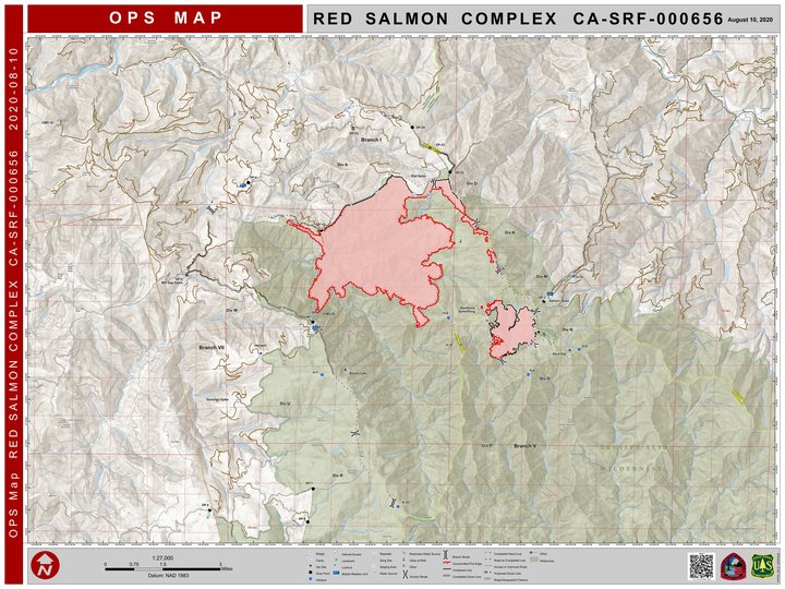
Map of the complex. More detail here.
CLICK TO MANAGE