
Smoke from the Red Salmon Complex. | Photo by the U.S. Forest Service.
United States Department of Agriculture press release:
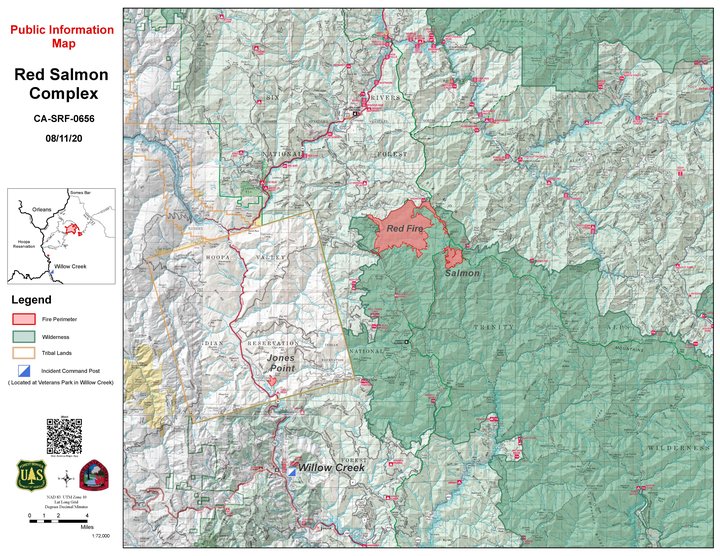
Current Situation: The Red Salmon Complex is 8,138 acres and 35% contained. The Jones Point Fire will be transitioning back to the Hoopa Valley Tribe at 6 p.m. tonight. The Red and Salmon fires are burning in the Trinity Alps Wilderness on the Six Rivers and Shasta-Trinity National Forests. All three fires are being managed for full suppression. Firing operations will pick up today around both the Red and Salmon fires, this combined with continued interior burning will produce more smoke throughout the entirety of the fire.
Red Fire: The fire is 7,234 acres and 17% contained. Fire behavior is expected to stay active in pockets of unburned fuel with group tree torching and short up-slope runs. Increased smoke production is expected in areas where firing operations will be conducted to tie in with the main body of the fire. The fire pushed the line along Packsaddle Ridge and crews successfully caught several slopovers while they worked to keep firing operations ahead of the progressing fire.
Crews will bring fire along the western edge of the Red Fire heading toward Mill Creek Gap. This fire eventually will connect on the northern perimeter near the South Fork of Red Cap Creek and Black Mountain. From the North Fork of Mill Creek, crews are firing south along Pack Saddle Ridge. Previous firing operations are beginning to connect to the main body of the fire and provide greater security for containment lines.
Salmon Fire: This fire is 767 acres and 89% contained. There is containment line all the way around the fire. Crews connected firing operations from the north to the Salmon Fire and will be burning from Salmon Mountain south to widen the depth of containment line. Mop-up and patrol operations will continue around the fire cleaning up areas of heat and ensuring containment lines hold.
Jones Point Fire: The Jones Point Fire is 137 acres and 75% contained. Last night, firefighters patrolled the line for heat. Today, mop-up operations will progress, focusing on isolated heat located with infrared flight over the fire last night.
Weather: Moderate instability will remain today as a weak upper low pressure begins to drift over the fire area. Today, temperatures will cool by about 5 degrees; however, a drier air mass will arrive bringing a slight increase in humidity.
Air quality: Heavy low-level smoke continues to drain into valley bottoms near the fire area and along the Bigfoot Highway affecting Orleans, Weitchpec, Hoopa and other communities in this region. These areas are expected to see periods of Unhealthy air quality with improving conditions late in the day. Westerly winds yesterday drifted higher level smoke east of the fire affecting communities such as Etna. These west winds remain today and smoke impacts in the Unhealthy for Sensitive Groups are expected for Etna and the Scott Valley today. Higher level smoke and haze is being transported far the northeast.
An air resource advisor is providing daily smoke forecasts and air quality information. Refer to fires.airfire.org/outlooks/NWCalifornia.Closures: The Red-Salmon Fire Complex Forest Closure takes effect on August 8, 2020. All National Forest System roads within the Red-Salmon Fire Complex Closure Area are closed as well as: Forest Road Nos. 07N53 (Grizzly Camp), 07N15 (Fawn Ridge), 10N05 (Upper Leary Creek), 10N01 (Trinity Summit), and 07N10 (Lone Pine Ridge). All National Forest System trails within the Red-Salmon Fire Complex Closure Area are closed as well as: Forest Trail Nos. 6E04 (Orleans Mt Trail), 5438 (Nordheimer), 12W08 (East Fork New River), and 12W02 (Salmon Summit). Big Rock River Access.
COVID-19: COVID-19 precautions are a priority at all incident camps with daily temperature screenings of personnel and implementing measures such as wearing face coverings and social distancing to prevent coronavirus spread. Community and firefighter safety are a top priority of both the incident management team and the National Forests.
Graphic provided by the USDA.
CLICK TO MANAGE