
Maj. Sonia Walker, 53rd Weather Reconnaissance Squadron aerial reconnaissance weather officer, verifies the dropsonde data is accurate before sending it via satellite to the National Hurricane Center. Photo by Rachel Becker for CalMatters.
###
We were flying about 200 nautical miles off the coast of California when a voice over the headset reported a strong smell of fuel in the back of the plane.
I was in the cockpit with the U.S. Air Force’s “Hurricane Hunters,” who spend the summer and fall flying into the eyes of hurricanes. On a Tuesday at the end of January, though, we flew out of Travis Air Force Base in California toward a different kind of storm: an atmospheric river that was moving east across the North Pacific, toward the West Coast.
“All right, you have my attention,” pilot Lt. Colonel Jeff Ragusa said through his headset. “Talk to me, Goose.”
The smell, it turned out, was a false alarm: a maintenance bucket that one of the crew had converted into a trashcan was contaminated with traces of fuel. “The crew is a little gun shy,” Ragusa told me. A fuel leak had forced them to end their last flight early.
The mission was to investigate an atmospheric river, a massive stream of water vapor and wind that condenses into rain and snow when it rises to flow over mountains. Just a few of these winter storms drop up to half of California’s yearly precipitation and have ended more than a third of the state’s persistent droughts.
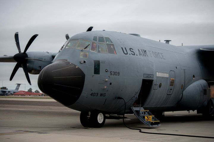
Pilot Lt. Colonel Jeff Ragusa in the cockpit of the Hurricane Hunters’ WC-130J Super Hercules aircraft, preparing to fly into the North Pacific to meet an atmospheric river. Photo by Rachel Becker for CalMatters.
But atmospheric rivers are also estimated to have caused about $43 billion of flood damage across the West over the past 40 years — including the $1.1 billion disaster when the Oroville Dam spillway crumbled under a deluge in 2017.
Knowing where and when these storms are going to hit and how much rain or snow they’re likely to drop is key in a region that reels between too much water and not nearly enough. Especially since climate change is expected to make these devastating cycles of drought and floods even worse.
That’s why scientists like Anna Wilson, field research manager with the Center for Western Weather and Water Extremes at Scripps Institution of Oceanography, have teamed up with the Hurricane Hunters and the National Oceanic and Atmospheric Administration to collect data during atmospheric river fly-overs.
“The presence or absence of atmospheric rivers can mean the difference between a drought year or a non-drought year,” said Wilson, who followed the Hurricane Hunters’ flight from the ground. But, she said, “Too many, or too strong, you can get into hazards. It’s crucial to understand them for California, and the whole West Coast.”
The Hurricane Hunters’ mission is part of a five-year state, federal, and local effort to improve forecasts of these storms, so dam operators and emergency responders know whether to prepare for dangerous flooding or store water for a dry spell.
On this flight, the crew was tasked with shooting oblong scientific instruments called dropsondes into the atmospheric river, where they collect information about temperature, pressure, humidity, and wind as the tubes parachute to the ocean’s surface.
The dropsondes radio a stream of data back to the crew on the plane; from there, it goes out via satellite to the National Hurricane Center and weather databases around the world. But less than two hours after the phantom fuel false alarm, we were turning around before firing a single dropsonde into the atmospheric river.

Senior Airman Donny Arseneaux, 53rd Weather Reconnaissance Squadron loadmaster on a WC-130J Super Hercules. Photo by Rachel Becker for CalMatters.
One of the crew had spotted actual fuel streaming past the right wing. An extra tank had sprung a leak, ending the mission early. I asked Ragusa, the pilot, how it felt. “Terrible,” he said. “It’s showing up for a sporting event and hearing that your team is forfeiting. It’s just, we don’t like to do it.”
A simultaneous Hurricane Hunters flight out of Hawaii managed to complete a similar circuit over the western end of the atmospheric river. And a few days later, the crew flying out of Travis successfully shot 24 dropsondes into the storm. Within hours, the research was helping shape forecasts of the atmospheric river that days later hammered Washington with rain, leaving flooding and landslides in its wake.
“Mother Nature doesn’t usually work that way.”
Right now, forecasters can see an atmospheric river coming a few days ahead of time, according to Marty Ralph, Wilson’s colleague and director of Scripps’ Center for Western Weather and Water Extremes. But the details are foggier.
The forecast’s location, for instance, can miss the mark by around 200 miles, Ralph said. That means flooding expected on the Russian River, which wanders south through wine country before taking a turn toward the Pacific Ocean, can instead hit the Eel River, which flows northwest from Lake County.
The goal is to narrow forecasts of the future by improving observations of the present. If you want to predict an atmospheric river, Ralph said, “We need to know where it is at the beginning.”
The idea is that more accurate forecasts and longer lead times could help reservoir managers better gauge whether to store water for a dry spell or make room for floods.
“Like the Goldilocks syndrome, we want just the right amount,” said Jay Jasperse, chief engineer and director of groundwater management with Sonoma Water. “Not too much, because then we’re dealing with flood, and not too little — because then we’re dealing with droughts. But Mother Nature doesn’t usually work that way.”
It’s a balancing act that scientists predict will only become more challenging as climate change worsens the state’s wet and dry extremes and shrivels the snowpack — a natural reservoir socked away on mountainsides rather than behind dams. This year’s snowpack was only 49 percent of normal on Feb. 24, California’s Department of Water Resources reported.
Atmospheric river research from the sky already helps that balancing act through a pilot project at Lake Mendocino, the Mendocino County reservoir that resulted from the completion of the Coyote Valley Dam in 1958.
Lake Mendocino is one of 36 dams the U.S. Army Corps of Engineers owns and operates in California, according to Nick Malasavage, chief of the operations and readiness division for the U.S. Army Corps of Engineers San Francisco District.
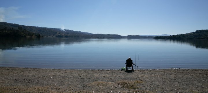
A fisherman at Lake Mendocino. Photo by Anne Wernikoff for CalMatters.
The lake is the smaller of two reservoirs that local water agency Sonoma Water draws from to supply some 600,000 people in Sonoma and northern Marin Counties with drinking water and agricultural irrigation. Three species of threatened or endangered fish also depend on water releases from the lake.
The reservoir has multiple roles, including recreation and water storage. But its main job is flood control — which became a source of controversy during California’s recent five-year drought.
The Corps followed a rule-book published in 1959 to guide water releases based on what scientists knew at the time about seasonal rainfall and runoff. But a lot changed in 60-plus years — including a drop-off in water routed to the lake through a nearby hydro-electric project.
After winter rains raised the lake’s level in December 2012, the manual told the Corps to release water to make room for future floods, even though none were in the forecast. Water levels dropped by about 35 percent and didn’t rise again for more than a year.
During the drought that followed, the lake shrank to a puddle — incensing local water officials, The Press Democrat reported at the time.
“A lot of people started to point back at the Corps of Engineers releasing that water that December, and say, ‘Well why did they do that?’” Sonoma Water’s Jasperse said. “All they had to do was basically look out the window across the Pacific, and it was dry as a bone.’
But it wasn’t the Corps’ fault — not really, Jasperse said.
“The reason we released all that water then was that you didn’t know if another storm was coming,” said Cary Talbot, division chief at the U.S. Army Engineer Research and Development Center’s Coastal and Hydraulics Laboratory. Plus, the rulebook required them to. Otherwise, he said, “Once you’ve filled up the reservoir, and it’s totally full, you’re completely at the mercy of nature.”
“Nothing focuses congressional funding like a disaster”
In the aftermath, Jasperse, Scripps’ Marty Ralph and the Corps of Engineers met to discuss whether there might be a better approach, Jasperse said. The big question: “How can we get more adaptive to our variable conditions?”
The effort worked its way to Washington, D.C. where Democratic U.S Senator Dianne Feinstein, Congressman Jared Huffman (CA-02), and others pushed for funding. Starting with $2 million in 2015, the Corps has now received roughly $30 million to explore using atmospheric river forecasts to improve reservoir operations, according to Talbot’s tally.
Feinstein also pushed through several million for the National Oceanic and Atmospheric Administration and the Air Force to fund atmospheric river research, according to Feinstein’s office.
“We have a saying in the Corps that nothing focuses congressional funding like a disaster,” Talbot said.
In California, lawmakers created an atmospheric rivers research, mitigation, and climate forecasting program within the Department of Water Resources. And the state chipped in millions of taxpayer dollars to help fund the research, including $9.25 million in the current budget.

The tower that houses the flood gates at Lake Mendocino. Photo by Anne Wernikoff for CalMatters
Both Assemblyman Jim Wood, a Democrat from Santa Rosa, and state Senator Bill Dodd, a Democrat from Napa, applauded the decision. “If you take a look at the amount of cost, it’s really a drop in the bucket compared to putting in a new dam,” said Dodd. “We want to do everything we can to keep the water supplies we have.”
In 2016, a policy update gave the Corps permission to consider forecasts in their plans for managing flood risk, rather than requiring decisions solely based on the water on the ground. But the Corps needed to figure out the right strategy, first.
That’s where Lake Mendocino comes in. It’s the site of an experimental effort called Forecast Informed Reservoir Operations, or FIRO — a proof-of-concept that incorporates weather and water forecasts into the Corps’ decisions to release water from the reservoir or hold on to it.
The Corps and the state are watching the results closely. California Gov. Gavin Newsom called for a roadmap to a more water resilient California in an executive order last year.
In response, the California Natural Resources Agency, California Environmental Protection Agency and Department of Food and Agriculture put together a set of recommendations: one of them is to evaluate rolling out forecast-informed reservoir operations more broadly across the state.
“This is going to be an evolution of water management in California,” said Michael Anderson, state climatologist with the Department of Water Resources and one of the people leading the effort at Lake Mendocino.
“Liquid gold”
So far, the program seems to be working; a dry-run in drought-busting 2017 showed that releasing water in advance of potential storms — rather than based on the manual’s rigid schedule — would have actually boosted the lake’s capacity to manage floodwaters. It also would have increased the water stored behind the dam by at least 5,500 acre-feet — enough water for more than 16,400 homes for a year, according to Talbot.
“We were able to use the virtual operations to basically calm any fears that we were going to break the system,” Talbot said.
Two years after the initial dry run, the Corps gave its approval to run the program for real. It was a wet year, with massive flooding that turned the Sonoma county town of Guerneville into an island.
None of that flooding, however, was worsened by the forecast-informed reservoir operations, according to Talbot. “Flooding at Guerneville was going to happen either way,” Talbot said. Only a small fraction of the water on the Russian River is controlled by Lake Mendocino and its partner reservoir, Lake Sonoma.“The dam did exactly what it was designed to do, which was lessen that flood.”
This year is looking drier, with storms early in the season that haven’t yet returned. And, thanks to the new program, the Corps held on to an extra 11,250 acre-feet of water, according to Sonoma Water — enough for roughly 33,000 homes.
“This would be basically liquid gold for us,” Jasperse said. “If we didn’t have this, we’d be very much worried about what Mother Nature is going to present us between now and March.”
Seeing the lake so full makes Kyle Farmer, a rancher in Potter Valley, happy every time he drives by it. “It’s a huge deal to become adaptive like that. I don’t think bureaucracies do that naturally,” he said. “It restored my faith in the government, obviously, a little bit.”
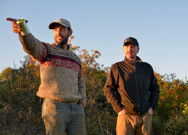
Kyle Farmer, left, and Norm Brown on the Magruder Ranch. Photo by Rachel Becker for CalMatters
Farmer lives and works on the Magruder Ranch, a 2,400-acre swath of hills and valleys where his wife’s family has farmed for five generations. It’s also home to one of six weather stations surrounding Lake Mendocino that help the reservoir managers figure out how much the water is likely to rise in a storm, according to Scripps’ Anna Wilson.
Perched on a ridgeline above Hell’s Delight canyon, the station measures wind, temperature, humidity, and pressure — like the dropsondes that fall through atmospheric rivers from the Hurricane Hunters’ plane. But it also measures soil moisture and temperature at different depths, as well as the sun’s strength and precipitation, providing key information about how much water soaks into the earth, or slicks off toward the reservoir below.
On a bright but windy Saturday, Farmer and Norm Brown, a retired Cal Fire deputy chief and a board member of the Mendocino Prescribed Burn Association, took me with them to the weather station as they crawled through the ranch on Farmer’s utility terrain vehicle, eyeing the hillsides he wanted to burn.
The trip took us about an hour and a half along a steep and bumpy dirt path that climbed from oak woodlands up to brushy chaparral along a ridgeline. We popped out of the vehicle along the way as Farmer and Brown gauged the risk for a prescribed burn near this cluster of oak trees, that glade of madrones, or the houses on the hillsides above.

The weather station on the Magruder Ranch, overlooking Hell’s Delight Canyon and Lake Mendocino. Photo by Rachel Becker for CalMatters
Farmer took a chainsaw to a fallen oak to investigate how old it was, struggling to cut through the hardwood as Brown told me over the noise about his own bloody chainsaw injury a few years before. The oak, Farmer guessed from the slice he managed to cut, was about 220 years old.
When we reached the weather station, the sun was dropping and the wind was picking up. The instruments towered over the nearby brush, separated from curious creatures by a barbed-wire fence.
Farmer pointed to the different devices, describing their functions: a spinning propeller blade he called an anemometer gauged wind speeds and direction. A white stack of saucers measured humidity. A camera snapped pictures, and a computer transmitted all the data back to the scientists in San Diego.
In the background, Lake Mendocino glinted from a fold in the dark green hills. “If it weren’t for that weather station right there, you might be looking at a puddle,” Farmer told Brown.
“I believe it will never rain again, until it does.”
The multi-government team spearheading the forecast-informed reservoir operations at Lake Mendocino plan to have the final assessment of the project finished in the fall. The complete assessment should help fast-track a permanent change to the 60-year-old Army Corps rulebook, Talbot said — although at that point, it’s out of his hands. “No guarantees on how long that’s gonna take. That’s not my process. It’s out of my realm,” he said.
In the meantime, the program is rolling out to other parts of the state: to the Yuba-Feather Rivers system east of Lake Mendocino, the Prado Dam in Southern California, and even, potentially, a dam in the Pacific Northwest, Talbot said.
“That’s, to my mind, a great success story,” said Anderson, the state climatologist. “People say, ‘Hey, this actually is a good idea. Let’s see what we can do to implement it more broadly.’”
Alfred White, director of viticulture at two vineyards downstream of Lake Mendocino, and a trustee of the Mendocino County Russian River Flood Control and Water Conservation Improvement District, calls the effort “common sense.”
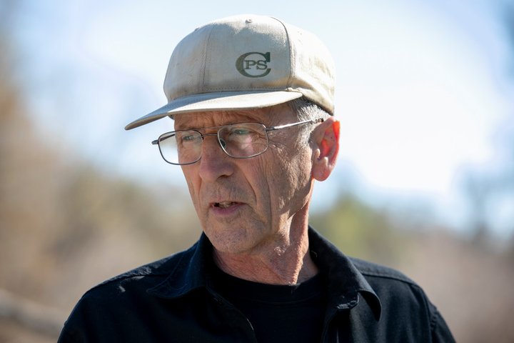
Alfred White, director of viticulture at La Ribera Vineyard. Photo by Anne Wernikoff for CalMatters
He met me on a dirt driveway at La Ribera Vineyard, took my keys, and drove me to where a stand of spiky agave separated the vines from a creek. He wanted to show me the water we’d been talking about.
A soft-spoken 72-year-old in a ball cap and glasses, White looked too dapper to be trekking through the dirt in a black button-down shirt and cargo pants. But we picked our way through the blackberry brambles and along the rocky creek bed to the Russian River.
White knows better than to read too much into the river’s water levels right now, which artificially rise and fall with releases from the dam.
But he can tell it’s been a dry year by looking at the creek, which dwindled to a trickle and disappeared long before reaching the river. “This time of year, this should be pretty strong flow through here,” he said.
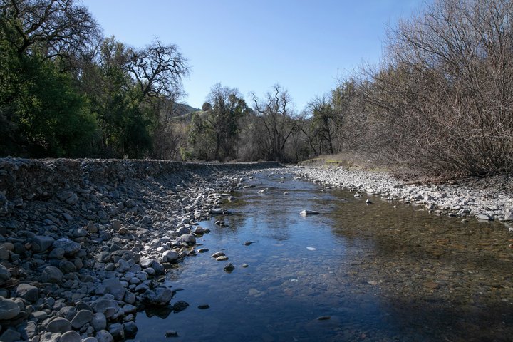
Low water levels in Morrison Creek, a tributary that feeds into the Russian River near La Ribera Vineyard. Photo by Anne Wernikoff for CalMatters
During the last drought, the state curtailed pumping from the river for anyone with a water right issued after 1954. The vineyard survived, but White worried that if it hadn’t rained the next year, the lake would have run dry. “This is a paycheck to paycheck kind of situation here,” White said.
He compares the forecast-informed reservoir operations at Lake Mendocino to a savings account. “If that paycheck doesn’t come in, you still have something in reserve to get you by that next year.”
It’s difficult to imagine needing that reserve as I struggle to hear White speaking over the sound of the river. But White’s lived in California long enough that when asked about the drought, he asks, “Which one?”
This year, the state looks ahead to what may be a dry spring. As climate change threatens to bring more severe swings from drought to deluge, White said he feels more comfortable with that extra water banked behind the dam. “We don’t know that we’ll be seeing any more rain,” he said. Living in California has taught him better. “I believe it will never rain again, until it does.”
###
CalMatters.org is a nonprofit, nonpartisan media venture explaining California policies and politics.
CLICK TO MANAGE