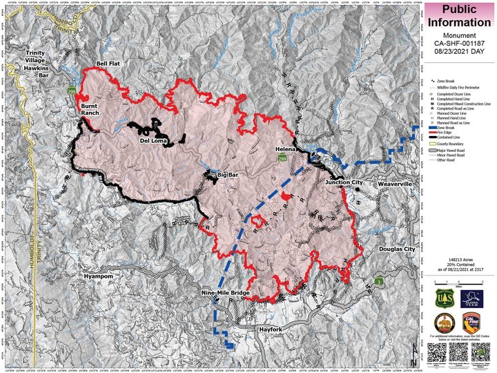
The latest map of the Monument Fire. | InciWeb
Monument Fire
The Monument Fire burning along Highway 299 in Trinity County between Burnt Ranch and Weaverville has surpassed 150,000 acres.
A team of 1,725 firefighters is currently working on the fire and has increased overall containment to 20 percent.
“Today, crews will continue prepping the communities of Hawkins Bar and Trinity Village in the event the fire spots across the New River,” the fire’s incident management team stated this morning. “The fire is slowly backing down Ironside Mountain east of the river and crews are monitoring the Bell Flat area for any spot fires that may pop up west of the river. Firefighters are working with the local fire department to help homeowners Firewise their properties while also opening up historic dozer lines that have been put in over the years for other fires.”
The Trinity County Office of Emergency Services is urging people to sign up with the CodeRed emergency alert system for the latest evacuation information.
Evacuation Orders: In effect for Hayfork, Sky Ranch Road, Red Hill, Canyon Creek, Coopers Bar, Big Bar, Del Loma, Bell Flat, Helena, Cedar Flat, Burnt Ranch and Barker Mountain. Junction City’s evacuation order has been reduced to an evacuation warning.
Evacuation Warnings: In effect for Junction City, Weaverville, Douglas City, areas south from Barker Mountain to Haystack, the north side of Hyampom Road from Hayfork to 9-mile bridge, Denny, Hawkins Bar and Trinity Village.
Evacuation Centers: American Red Cross Shelters have been set up at Shasta College, 11555 Old Oregon Trail, Building 1900, Redding CA; Willow Creek Bible Church, 39 Brannan Mountain Road, Willow Creek, CA; and Fireman’s Hall Pavilion, 9 Park Street in Fortuna.
Animal Evacuation: (Domestic animals) Trinity County Animal Shelter, 563 Mountain View St, Weaverville, CA (530- 623-1370). (Domestic + Large Animals) Hoopa Rodeo Grounds on Pine Creek Rd, Hoopa, CA. (Large Animals with the exception of Swine): Redding Rodeo Grounds, located at 715 Auditorium Dr., Redding, CA (Sandy Ekman 530-739-8469)
Highway 299 remains closed Between Pony Creek Road and Felter Gulch.
A damage assessment team confirmed that 32 structures have been destroyed by the fire. For information regarding property damages, contract the Trinity County Office of Emergency Services at (530) 623-1116.
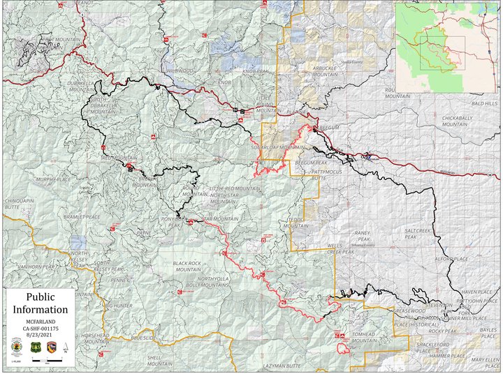
The latest map of the McFarland Fire. | InciWeb
McFarland Fire
The McFarland Fire burning along Highway 36 in Trinity County has grown to 118,090 acres and is now 68 percent contained.
A damage assessment team has confirmed that 20 residences and 18 other structures have been destroyed by the fire. Damage assessments are ongoing. A map of the destroyed structures and images of the properties can be found by clicking this link: visit:https://arcg.is/1Pu8GW
“As fire activity slows and containment increases, crews are taking opportunities to start working on interior areas of the fire, opening roads that were compromised, snagging dead trees, and beginning the process of suppression repair,” the fire’s incident management team stated this morning. “During suppression repair, roads and culverts that were damaged during the fire fight are repaired, and water bars are added to help prevent erosion during winter rain.”
A team of 813 firefighters are currently working to contain the blaze, including 13 hand crews, 73 engines, 7 helicopters, 14 dozers, 20 water tenders and 3 masticators.
Evacuation Orders and Warnings:
Shasta County
ORDERS: The Shasta County Sheriff’s Office has issued a mandatory evacuation order for all residents within the township of Platina. The evacuation order includes all residences and roadways from the Trinity/Shasta County line east to the Shasta/Tehama County line. Residents are encouraged to use Platina Road as an evacuation route. There will be a temporary evacuation site at the Igo/Ono Elementary School. https://www.facebook.com/ShastaSheriff
Tehama County
ORDERS: The area west of Vestal and Weemasoul Roads to the Shasta/Tehama County line and south of Highway 36 in the fire area.
WARNINGS: Highway 36 from Bowman Road west to the county line and north to the Shasta County line (Zone 157). The area south of Highway 36, east of Vestal and Weemasoul Roads, north of Pettyjohn, and west of Cottonwood Creek and Vestal Roads in the 4 corners area (Zones 158 and 169). Please click here to view the map for Tehama County: https://tinyurl.com/Evacuation-and-Road-Closure
Highway 36 remains closed between Harrison Gulch to Vestal Road.
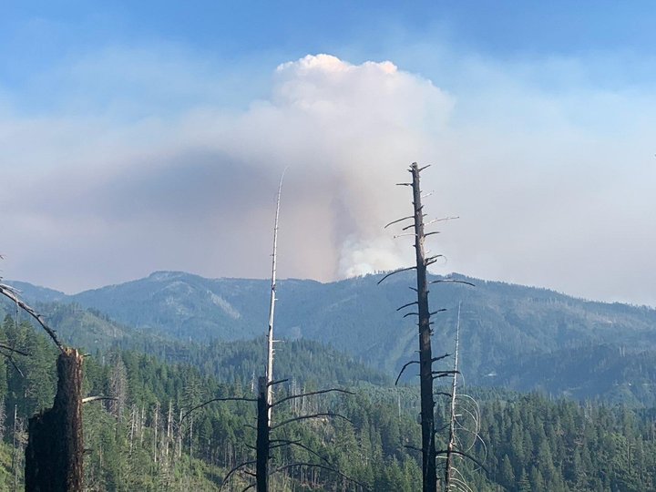
The McCash Fire. | InciWeb
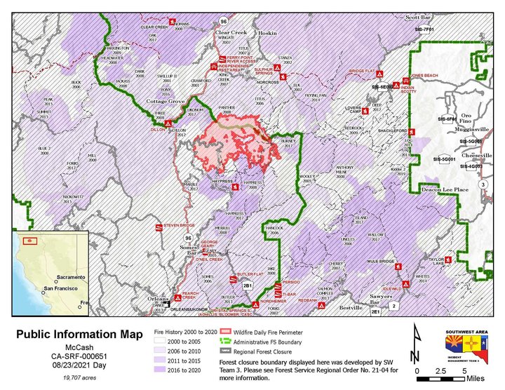
McCash Fire
The McCash Fire burning in the Klamath and Six Rivers National Forests east of Highway 96 is now 19,707 acres in size and 0 percent contained.
“Fire growth continues to threaten communities along the Highway 96 corridor between Independence and Rogers Creek,” the fire’s incident management team stated this morning. “Fire continues to grow on all sides, but the majority of the McCash fire resources are engaged in structure protection activities in these areas. Night operations continue to take advantage of opportunities to slow fire spread west towards Highway 96. Fire growth is expected to continue in the Marble Mountain Wilderness.”
A team of 364 firefighters is currently working to contain the blaze, including one hotshot crew, two Type 2 IA crews, two type 2 hand crews, nine engines, three Helicopters, five dozers, four water tenders and 10 masticators.
Evacuation Orders:
For the most current and accurate evacuation information for Siskiyou County, visit the Siskiyou County Sheriff’s Office Facebook page at: https://www.facebook.com/SiskiyouCountySheriff or the county evacuation map at: https://www.arcgis.com/apps/webappviewer/index.html.
All residents are encouraged to sign up for CodeRED Emergency Alert at: https://www.co.siskiyou.ca.us/emergencyservices/page/codered-emergency-alert.
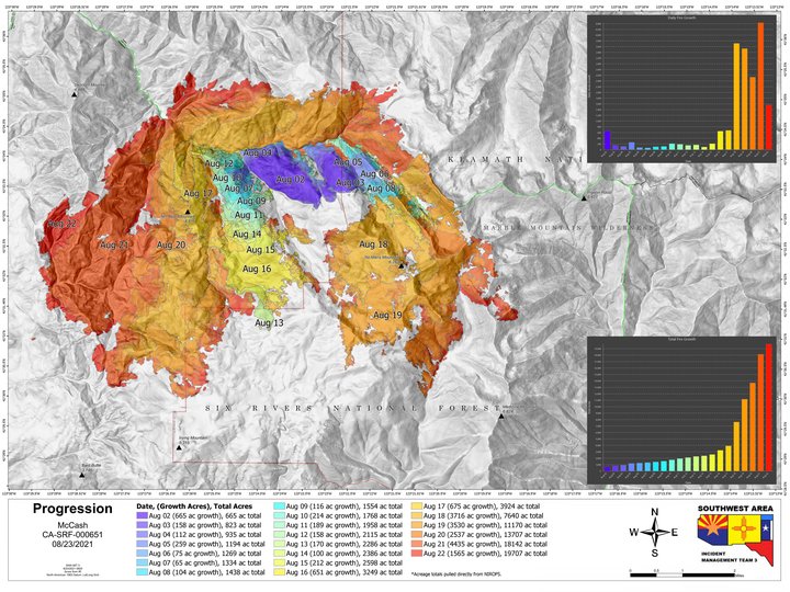
The latest McCash fire maps. | Inciweb
CLICK TO MANAGE