
The Eel River is forecast to reach flood stage Monday night or Tuesday morning. | Image via NOAA
# # #
With local rivers already swollen from three weeks of above-average rainfall, Humboldt, Del Norte and Trinity Counties are all under an active flood watch this morning as continued downpours are projected to flood rivers, creeks, streams and low-lying areas.
Cue the ark jokes.

A “severe” flood warning has been issued for this region. | NOAA
As you can see in the graph above, the Eel River is forecast to reach flood stage at Fernbridge sometime tonight and continue rising through Tuesday, finally peaking at above 23 feet late Tuesday or early Wednesday. A “severe” flood warning has been issued for the Eel River Valley, lasting from 5 a.m. tomorrow to 1 p.m. Wednesday.
A Special Action Advisory is being issued to people who own livestock in all low-lying areas adjacent to the Eel River. The National Weather Service says “appropriate action” should be taken to protect livestock.
Of course, the forecast can change quickly, so keep tabs at this link to stay up-to-date.
The City of Rio Dell issued a flood warning this morning, saying portions of State Route 211 between Fernbridge and Ferndale could go underwater, along with much of the Eel River Valley, including areas northwest of Loleta and the western portion of Cannibal Island Road.
This deluge looks a lot like the conditions we saw six years ago, when the Eel crested at 23 feet, turning the Eel River Bottoms into one big lake, nearly submerging Duluwat (aka Indian Island) and turning the Arcata Bottoms into a soggy bog.
We’ll be keeping tabs on local conditions as the water levels continue to rise.
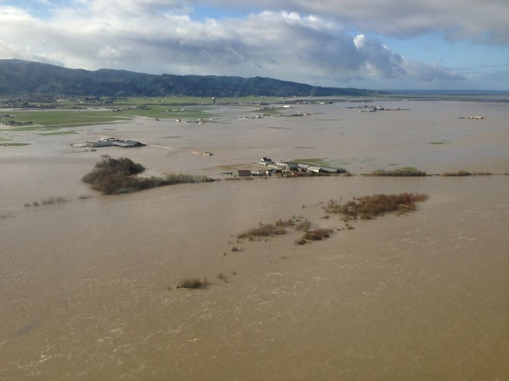
Ferndale Bottoms in 2017. | File photo.
CLICK TO MANAGE