In the not-too-distant future, if all goes according to plan, bicyclists and pedestrians will be able to traverse Eureka north to south – from Humboldt Bay to the Sequoia Park Zoo – on a dedicated trail.
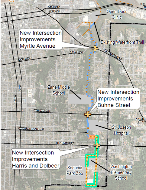
Image via the City of Eureka. Click to enlarge.
It’s been a while since we’ve heard about the Bay to Zoo Trail, a project which, as its name suggests, would link the Waterfront Trail at the north end of Eureka to the Sequoia Park Zoo via two miles of Class I bike path and non-motorized facilities through the city. The trail would also connect with Zane Middle School and Washington Elementary to provide a safer route for kids to walk to school.
Eureka’s Open Spaces, Parks and Recreation Commission heard an update on the trail project last week. City staff has taken care of a significant portion of the environmental documentation required for the project, but there’s still a lot of work to do.
“In 2020, the [California] Coastal Conservancy awarded us about $100,000 to do the environmental document … that helps [identify] your areas of sensitive habitat,” Scott Ellsmore, the city’s traffic project manager, explained during last week’s meeting. “It gives you an idea of where you’re working and what you’re doing. It’s an important step in the project because, if you haven’t done it, you’re kind of making some big guesses. … That was a nice checked box that helped us when we went back for the next round of funding.”
At the end of last year, the California Transportation Commission (CTC) approved another $9 million in funding for the project through its Active Transportation Program (ATP), which provides funding for new walking and biking projects for disadvantaged communities across California. To secure the funding, the city has to file a bunch of paperwork with the state. This is what Ellsmore calls “the paperwork phase” of the planning process.
“That process leads us to [around] October 1 when will actually receive the green light to say, ‘Okay, good. You can begin actual work on this project where you can be reimbursed or you can receive funding.’” he said. “We can’t do much right now [because] we don’t actually have funds. We’re just kind of in that planning process.”
Another piece of the project is a proposed roundabout on Myrtle Avenue, near those odd dome-shaped buildings at the McFarlan Street intersection, that would include an enhanced bike lane and create a connection point between neighborhoods.

Image via the City of Eureka. Click to enlarge.
It’s a little difficult to make out the details in the rendering above, but basically what you’re looking at is Myrtle Avenue going right down the center and McFarlan Street branching off to the left. That solid, dark grey line coming from the right is the proposed route of the trail. It would connect to a sidewalk (the speckled grey paths) surrounding the roundabout and either feed bicyclists into a bike lane on Myrtle Avenue or allow them to cross at the crosswalk to continue on the trail.
“It’s important to remember that these design plans are very preliminary,” Ellsmore said. “There’s a reason we don’t have roundabouts in Eureka. It’s because they require a large footprint and they typically start to encroach on properties. … In this case, we know we have the room and the footprint will work, but the final details are pretty rough. Until we get in there and actually design it, we’re not gonna know what it will look like.”
Once staff is given the green light on the design elements of the entire trail project, they’ll begin the permitting process and initiate conversations with property owners about access agreements and purchasing easements.
“That is one of the most important things because there’s a lot of folks that are that are interested and concerned about how the trail will affect them,” Ellsmore told the Outpost in a phone interview. “When we’re conceptually trying to figure out trails, we draw a line from the beginning to the end. … And then we start to drop in the property lines and get into more detailed levels of design. Once we have a likely route, we start to reach out to the nearby property owners and see if they’re interested in selling an easement for trail access.”
That process will probably take a couple of years but, once it’s complete, staff will refine the exact route and design of the trail, finalize the plan and put the project out to bid.
Construction of the trail is expected to cost around $10 million. The city is hoping to break ground in May of 2026.
PREVIOUSLY:
- Calling All Trail Fans! You’re Invited to a Community Meeting on the Proposed ‘Bay to Zoo Trail’
- Millions of State Dollars Headed to Humboldt for New Walking Projects and Biking
###
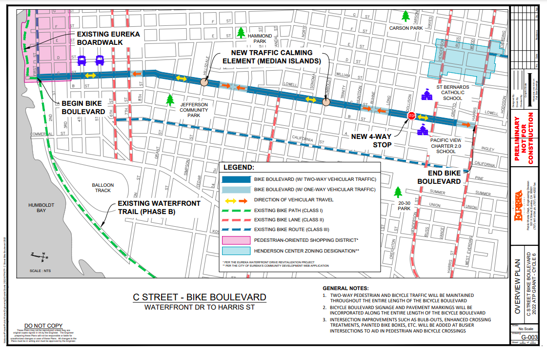
Image via the City of Eureka. Click to enlarge.
Ellsmore briefly mentioned Eureka’s C Street Bike Boulevard project during last week’s meeting. The project would implement traffic calming elements and other bicycle and pedestrian safety improvements at busy intersections between Old Town and Harris Street.
“It would be a really, really cool improvement,” he said. “C Street is a pretty low-volume street but it’s also a great direct north-south connection through town. … It would have [curb extensions], improved crossings on some of the busier streets, like rapid flashing beacons, as well as some resurfacing.”
Caltrans earmarked another $2.3 million in ATP funds for the project. The design should be finished by the end of this year. Construction is expected to begin next summer.
CLICK TO MANAGE