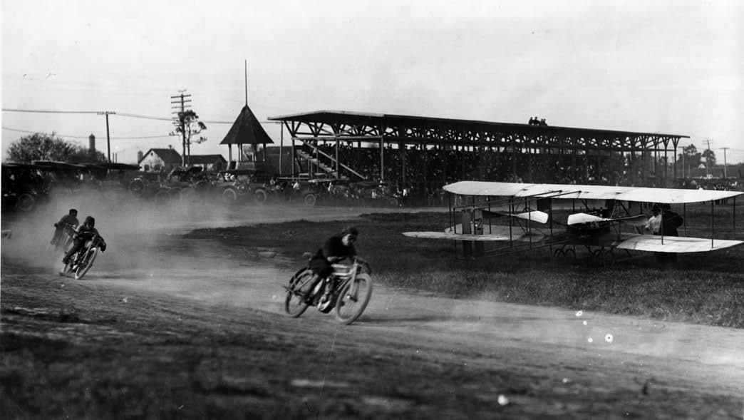
Motorcycle races and a biplane create thrills at the third South Park Race Track on July 4, 1913. Photos via the Humboldt Historian.
The following survey of resources on Eureka’s South Park Race Track appeared in the Winter 2015 issue of the Humboldt Historian. For a bibliography of works referenced by Mr. Rohde, click here.
###
Broadway Street in Eureka long served as a topographical dividing line. West of it were various wetlands, including those of the Clark’s Slough drainage, while to the east was higher, more solid ground, emphasized by a long bluff that rose abruptly just beyond the east side of the roadway. Dwellings and a few commercial buildings came to occupy the east-of-Broadway area, but there was little early development in the wetlands to the west. For decades, the most extensive constructed feature west of Broadway was the South Park Race Track.
Between 1869 and 1920 there were at least three versions of the track. The first was built by physician and land developer Jonathan Clark in 1869 (Fountain 2001:(51)5) on property originally acquired by Clark as swamp and overflow land (Fountain 2001:(67)5). This track is depicted on the 1870 U. S. Coast Survey map of Humboldt Bay. The map shows an early day road following the approximate course of today’s Broadway Street; it runs a short distance east of the Clark Slough wetlands. In the area between today’s Wabash Avenue and 14th Street the map shows a projection of dry ground west of Broadway. A causeway leads westward from this projection, crossing Clark’s Slough and the surrounding wetlands and ending at the “South Park Race Track,” an oval on a nearly north-south axis that is skewed slightly to the northeast/southwest. The track ran from today’s 14th Street (formerly Whipple Street) south to a point on a line extending due west from Trinity Street. (U. S. Coast Survey 1870; Lentell 1901).
The 1870 map shows at least four structures in the area near the eastern end of the causeway. One is I-shaped and another L-shaped. Both are long and narrow. The L-shaped building was located near the northwestern corner of Broadway and Wabash, approximately where Adel’s Restaurant and parking South Park Race Track, with houses on north end of Fairfield Street on the bluff in the background. lot are at present. The I-shaped building was situated near the corner of Wabash and Koster streets and ran north from there across Wabash into the property now occupied by SHN engineering. Given the shape of these structures, it is likely that they were stables for the horses that ran at the race track. One account indicates that a man named Frank Winters “lived in the South Park area (Wabash and Broadway),” where he rented two stables “across Broadway from the Old South Park Hotel” (Long 1977:8). The South Park Hotel was located in the 1600 block of Broadway (Standard Publishing Company:70; Pacific Coast Publishing Company 1898:115; Polk-Husted 1914:150), which would place it just south of today’s Eureka Natural Foods store. Despite the above report, it is unlikely that the stables were across Broadway from the hotel, which would put them on the east side of the street and at a greater distance from the race track. More likely they were adjacent to the hotel on the west side of Broadway, in the location of the buildings depicted on the 1870 map.
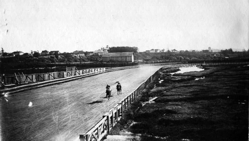
South Park Race Track, with houses on north end of Fairfield Street on the bluff in the background.
In 1887 Jonathan Clark’s son, William, built a new race track at South Park (Irvine 1915:332). It was deemed “peculiar” because “it is of saw-dust, from Flanigan and Brosnan’s mill, hauled and dumped on the marshes.” The new track was to be a mile in length. No mention was made of the length of the previous track (Fountain 2001:(67)1).
The mill referred to was the Flanigan, Brosnan and Company mill at the foot of Whipple (14th) Street, which was located a short distance northwest of the race track (Carranco 1982:199; Lentell 1901). The mill and its related logging operations were renamed the Bayside Mill and Lumber Company in 1902 (Carranco 1982:202). An undated photo shows the southeastern portion of the track, with the bluff upon which Fairfield Avenue runs clearly visible in the background. A barn-like structure below the bluff may be associated with the race track.
In 1903 William Clark had this second track demolished:
William Clark, owner of the land, has concluded that a [race] track is far from being a profitable investment and determined recently that he would subdivide at least a portion of the land, and put it on the market for sale. Carrying this determination into action, he has put a force of men at work tearing down fences, clearing out brush and doing extensive work on Murray [Del Norte] Street, which when completed, will cut the track almost in half (Fountain 2011:(67)5).
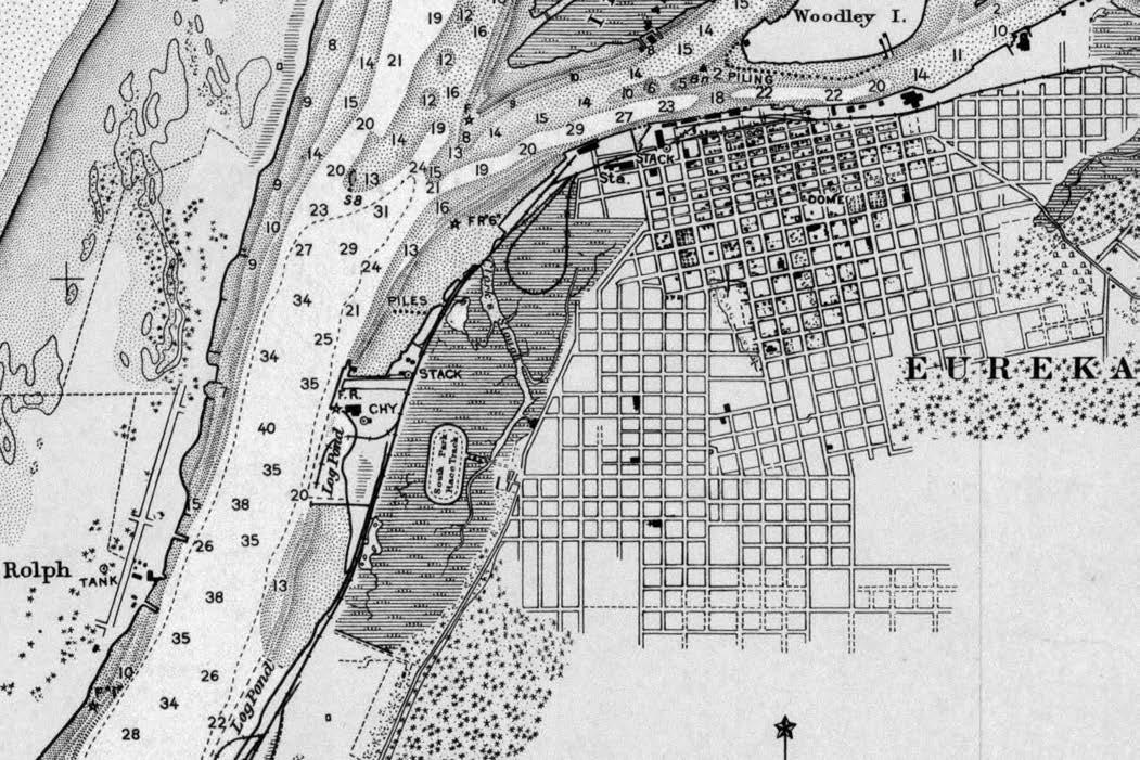
This H. S. Richardson Map of Eureka, 1906, shows the South Park Race Track on Clark’s Slough, to the left of current landmarks, Broadway and Adel’s.
A city map from 1906 shows Clark’s new subdivision superimposed over the second race track. Both Murray Street (now Del Norte Street) and Hawthorne Street cut through the southern half of the former track (Richardson 1906).
A third iteration of the track was built in 1909, in part by Oliver Swanson, who was the proprietor of the nearby South Park Hotel. (Irvine 1915:750). One Eureka old-timer referred to it as the “half-mile track” as opposed to the “1-mile track” it replaced (Long 1976:29). Swanson operated the track under lease until 1914, “when he sold his South Park interests” (Irvine 1915:750). Because of Clark’s subdivision to the south, the new track could only run in the area between Murray and Whipple streets, which would account for the shortening of its length. An aerial photo from 1931 shows indications of two different alignments of this track (Laird, et al. 2007). The various race tracks and their operators are listed in at least six different business directories, as follows:
- 1877: South Park race track, Clark’s Addition, O. T. Rouse, proprietor (McKenney 1877:22);
- 1898: South Park Race Course, Thomas A. Haney, lessee, near South Park Hotel (Pacific Coast Publishing Company 1898:115);
- 1904: South Park Hotel and Race Track, J. McDonald, proprietor, Broadway near Wabash (Herald Printing Co.:155);
- 1911: South Park Race Track, Whipple near Broadway (Polk-Husted 1911:127);
- 1916: South Park Race Course, Broadway near Wabash (Polk-Husted 1915:202);
- 1920: South Park Race Course, Broadway near Wabash (Western Directory 1920:156);
No records have been located giving the date the race track ceased operation. A 1931 aerial photo of Eureka suggests that the track closed considerably different tracks between Whipple and Murray; they earlier. The image shows the vague outlines of two both run on a nearly straight north-south axis in still-vacant land about midway between the Northwestern Pacific Railroad tracks and Broadway. They apparently represent two different alignments of the third track. An outline of the older, “one-mile” track is also still partially visible in areas that have not yet been developed. A 1948 aerial shows a similar situation, but a 1954 aerial shows much of the area south of Whipple now filled with structures (Laird, et al. 2007). The 1938 Lentell city map shows the entire area between Murray and Whipple streets now occupied by “Clark’s South Park Addition” and the “Third Enlargement, Clarks’ Addition” (Lentell 1938), although as the aerial photos indicate, these additions were yet to be fully developed. A 1947 aerial photo shows the remnants of race two tracks (Shuster 1947a). Another 1947 aerial shows the Debon Motor Company occupying the west side of Broadway at the intersection with Hawthorne Street. Running roughly parallel to Broadway approximately 50 feet to the west is a broad corridor that appears to be the remains of “mile-long” race track (Shuster 1947b).
No full account of the race tracks has been located. Several short statements provide summary information, however:
- October 1, 1869: proprietor Jonathan Clark certifies that, pursuant to certain conditions, “George McFarland is entitled to free admission to the South Park Race Track … and is also entitled … to drive his own team and train his own horses … ” (Fountain 2001:(46)94).
- September 25-27, 1872: “Fair held at South Park. Mrs. Fenton Tomlinson had charge of the Dining Saloon at South Park dairy fair” (Fountain 2001:(83)154).
- October 1, 1873: George McFarland notes that the “County Fair began at South Park” (Fountain 2001:(46)179).
- September 22, 1887: “The new mile track will not be completed in time for the Fall races of the Eureka Jockey Club. Notwithstanding, the Club has arranged for a very successful meeting, and good races will be justified by good purses. Merchants, hotel keepers and others have contributed very liberally of their funds, thus enabling the Club to offer some tempting prizes for competition on the turf ” (Fountain 2001:(67)1).
- Summer, 1911 (as recalled by John McCarthy): “It was Jake or Sid Lowenthal who went through the fence, taking out two lower boards. He passed just under the top board. Clarence Turner won the race … ; here is [sic] some of the boys who raced in the South Park races: Clarence Turner, Jake Lowenthal, Sid Lowenthal, Fred Lundblade, Roy Dennison, Grey Sequiros, Louie Warren, Fred Sundberg, Irv Falk, Wm. Donilson, Frank Maxwell, Joe Miller, Fred Cabrel, and Joe Adorni” (Genzoli 1971:9).
Newspaper columnist Will Speegel recalled harness racing at South Park: “Jacob Loewenthal owned a splendid animal that won the track speed record,” but the horse’s sister “was brought in from the Peter Hauck farm and sneaked up on her brother to give him a good drubbing and wrest much gold from the pockets of … [his] backers, among whom were the Drs. Falk, Otto Newcomb, Max Baer and others …” (Speegel 1944).
Speegel also told about another type of racing:
In the bicycle days one particularly interesting and lucrative event (for some of the riders) was staged at the South Park race track. The best riders of the state came here, and found plenty of competition from the best riders of this community. Among those who copped big prizes were Rudolph Ohman, Guy Roberts, the Hauck brothers, Lou Putnam, Bert Waite and dozens of others (Fountain 2001:(61)125).
J. W. McCarthy provides the most detailed account of the race track:
The South Park Racetrack was located on Broadway Street at the foot of Wabash and Fairfield Streets. The entrance was next to the South Park Hotel and Bar run by a Mr. Shaw. The track held both harness and running races. The harness races, both trotters and pacers, were run in heats, the winner being the one who won two of the three races. It was not uncommon to have a matched race after the regular program was run … .
Balloon ascensions and airplane flights were also made from this park: they were not always successful.
Motorcycle races were held on the track during the summer months (McCarthy 1982:65).
Today, no known remnants of any of the tracks remain.
At an unknown date a lodging house called the South Park Hotel was built on the west side of Broadway near the race track. No account has been located about the hotel or the auto court/motel that later developed next to it.
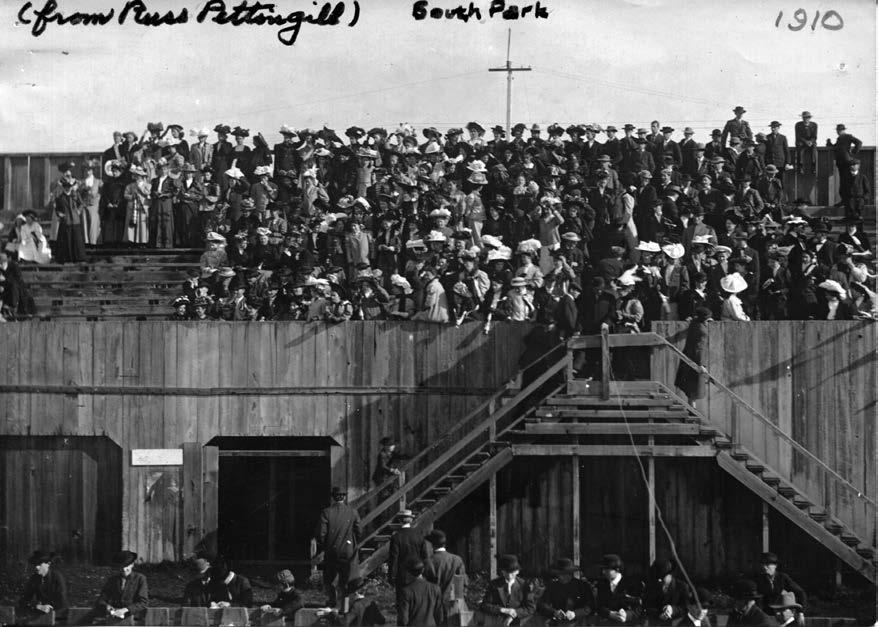
Crowds throng the grandstands at South Park in 1910.
###
The story above was originally printed in the Winter 2015 issue of the Humboldt Historian, a journal of the Humboldt County Historical Society. It is reprinted here with permission. The Humboldt County Historical Society is a nonprofit organization devoted to archiving, preserving and sharing Humboldt County’s rich history. You can become a member and receive a year’s worth of new issues of The Humboldt Historian at this link.
CLICK TO MANAGE