The meeting of the grids. In red: The “Waterfront” grid. In blue: The newer, or “North-South” grid.
###
One of the first things I noticed about Eureka when I moved to Humboldt County in 1979 was that my sense of direction, usually good, experienced problems when I visited. The part of town that was letters and numbers was okay: When I drove into town on 101 from my home in Westhaven, the first light was W, and the alphabet went backwards as I passed through. 101 was Fourth Street (or was it Fifth?) The lowest-numbered streets were to my right, in Old Town, and they got bigger as you headed away from the bay. So far, so good.
After that, things became less organized. For example, the numbered streets stopped before even reaching 20. After that, one entered a funhouse of alternative geography: Del Norte Street was followed by Sonoma Street, which was followed by Humboldt Street … And then there were the boulevards. Why did so many of them sound the same? Was Harris the one that went by General Hospital? No, that’s Harrison. Harris is the one you can use to bypass downtown if you come the back way from Bayside, and don’t miss the turns, and know it becomes one-way so you have to turn down “I” Street, also one-way. Then prepare to merge left so you can turn onto Henderson, which will take you to 101 … which is now called Broadway. Going home, you can take Henderson, too, but only for a block to the top of the hill. Oops! You wanted Harris!
But that’s all part of the fun of learning a new place – most towns have their tricky bits. As the years passed, I learned my way around — even knew to call Buhne “BOON-er” Street. But I still noticed some intriguing oddities: Why is there that jog in H and I when you pass through town? Why does the alphabet on some cross streets go A, B, C, Lowell, William, D, E? And is it “William,” or “Williams”? The street signs literally go back and forth almost every intersection …
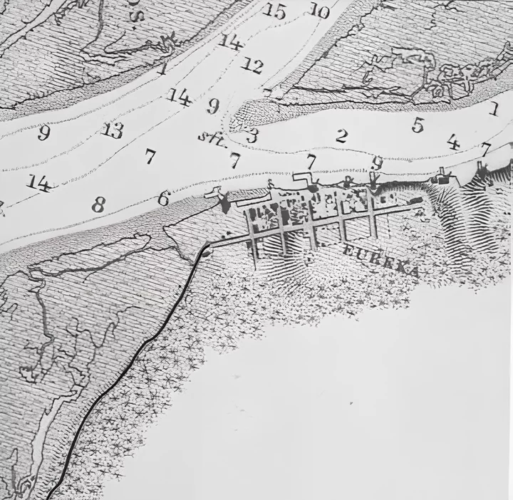
From “Preliminary Survey of Humboldt Bay California —1858,” United States Coast Survey. Images via the Humboldt Historian.
To solve a mystery, start with what intrigues you, and begin looking for clues. With matters of geography, my favorite sources are maps, so I started with the earliest maps I could find. As Eureka was settled from the water, it made sense that its earliest maps were actually charts. The one above, from 1858, shows the town at its beginning — a row of blocks facing the Bay radiating off 2nd Street, which connects to the trail heading south to Bucksport and beyond. The streets perpendicular to 2nd, today’s E, F, G, H, and I, have already initiated the grid that will dominate Eureka — 60-foot streets dividing 240-foot-square blocks. Most importantly, it shows 2nd Street aligned to run parallel to the Bayfront, which here has a bearing 10 degrees south of due West. Therefore, the perpendicular alphabet streets are oriented 10 degrees east of due south.
This orderly grid of right-angled streets — oriented to a shoreline running 10 degrees “off-plumb” — became the framework of Eureka’s early development. An 1870 map (below) shows dwellings scattered along its thoroughfares as far south as the future intersections of 13th and J and 11th and E Streets. Old Town’s blocks are solid with businesses, and houses stretch eastward along 3rd and 4th Streets all the way to Myrtle Avenue.
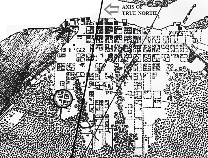
Circle shows future intersection of Washington and B Streets in Clark’s Addition. From “Part of Humboldt Bay California—surveyed in 1870.” United States Coast Survey.
But the 1870 map also shows the first sign of a different plan. On the southwest edge of town, surrounded by trees on 3 sides, is a tiny grid, centered at what will become Washington and B Streets. This is the first developed portion of “Clark’s Addition,” platted in 1866 by Eureka landowner Jonathan Clark. Though he kept the city’s template of 60-foot streets and 240-foot-square blocks, Clark made one crucial change — he tilted the axis of his grid 10 degrees west, bringing it into alignment with the cardinal points of the compass. By the time Jonathan and his son William finished subdividing the Clark acreage, over 150 new blocks had been added to Eureka — all with a true North-South-East-West orientation.
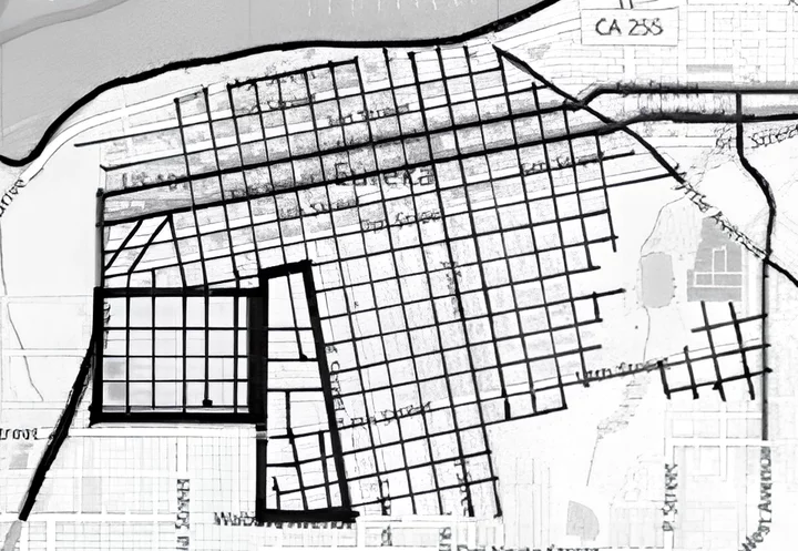
Extent of the Bayfront Grid in Eureka, 2020 plus: Rectangle outlining Clark’s Addition, polygon outlining “The Wedge”
After 1870 the original Bayfront Grid grew a bit further south and east, but by 1900, the compass had won — the original pattern was entirely surrounded by tracts oriented to True North. And so it has remained to the present day. Wabash Avenue marks the original grid’s southern frontier from C to its end at H, with its invisible presence continuing east, creating the mid-block jogs in both I and J Streets at that point where Wabash would cross them if it ran that far. At K Street, 15th becomes the boundary, except for a small part of the “Weeks Addition” east of Cooper Gulch, where the tract line runs through the blocks between 15th and 16th before ending at West.
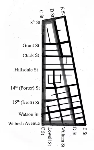
But where the Bayfront and True North grids have their most interesting interaction is in the part of town I call “The Wedge.”
At 8th Street, C and D Streets are separated by a standard Eureka 240-foot-square block. But as C begins its Clark-ordained 180-degree-due-south trajectory, it immediately begins diverging from D, its old-school-10-degrees-east-of-south neighbor. A half-mile later at Wabash, the two streets are more than 700 feet apart. This creates room for an extra 2-and-then-some blocks of grid — as well as the need for two new streets to divide them. So the special “Eureka alphabet” is created — sing along, now! “A, B, C, Lowell, William, D … E, F, G … ”
The Wedge is also home to the town’s most interesting street-and-alley configurations, bred by its odd shape and having been platted by several different owners. Its housing stock reflects the full range of Eureka’s diversity, with particular strength in the late Victorian and early Craftsman eras. While Hillsdale Street may be its most renowned thoroughfare, the entire neighborhood and the blocks surrounding it are filled with “gifts to the street” both architectural and horticultural. As a final treat for the historically minded, it’s also an area rich in curb stamps, showing both original street names and creative interpretations of familiar favorites.
And now to our final mystery: Is it William or Williams? All the old maps agree on “William,” as does Google Maps and Eureka’s GIS, but “the word on the street” is literally split down the middle — of the eighteen street signs within the city limits, there are nine with each spelling.
And the winner is … “William!” Local historian Bob Libershal cites Blue Lake archivist Susie Baker Fountain as reporting that the street was named for Jonathan Clark’s son (or brother) William.
But those “Old Ways” officially end at the city limits. The appropriately variate end to our story lies a half-mile or so south of there. In the unincorporated community of Rosewood, a two-block stretch of The Street with Two Names is consistently signed and Officially Known by the County of Humboldt as … Williams.
###
The story above was originally printed in the Fall 2020 issue of the Humboldt Historian, a journal of the Humboldt County Historical Society. It is reprinted here with permission. The Humboldt County Historical Society is a nonprofit organization devoted to archiving, preserving and sharing Humboldt County’s rich history. You can become a member and receive a year’s worth of new issues of The Humboldt Historian at this link.


CLICK TO MANAGE