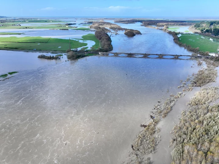
UPDATE, 1:58 p.m.: Dronin’ on the River
Video: Submitted.
Come fly with us on a tour of the delta.
— Hank Sims
###
UPDATE, 1:06 p.m.: About a Dozen Local Roads Closed Due to Flooding
— Isabella Vanderheiden
###
###
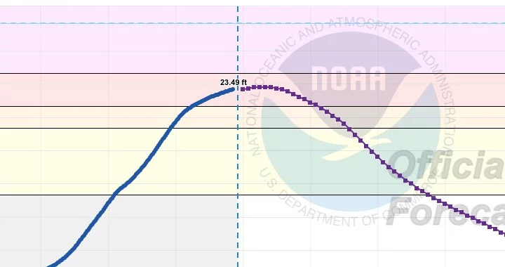
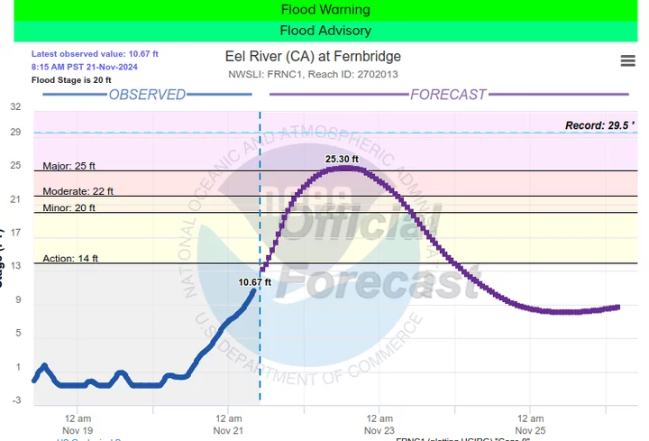
UPDATE, 11:07 a.m.: The Eel River is No Longer Expected to Reach ‘Major Flood’ Stage
As noted in the detail above — from the graph on NOAA’s Eel River @ Fernbridge monitoring page — the river is no longer expected to cross up into the purple zone. The bridge will likely remain open; the flood will continue to swell a bit for another hour or two, and then recede.
Meanwhile, here’s a snippet of Lost Coast Communication General Manager Roger Harrell’s adventures through the Elk River/Berta Road area this morning:
— Hank Sims
###
UPDATE, 10:41 a.m.: Evacuation Orders Downgraded
The low-lying areas of the Loleta bottoms were placed under evacuation orders yesterday.
Those orders have now been downgraded to warnings. You may return to your cattle.
— Hank Sims
###
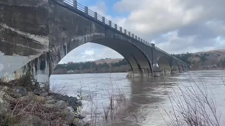
UPDATE, 10:22 a.m.: Fernbridge Is Open!
Looks to be holding strong so far! Here’s bridge-crossing video from a few minutes ago.
— Hank Sims
###
UPDATE, 4:52 p.m.: Someone Got Trapped Inside the Vance Hotel’s Elevator During the Eureka Power Outage
###
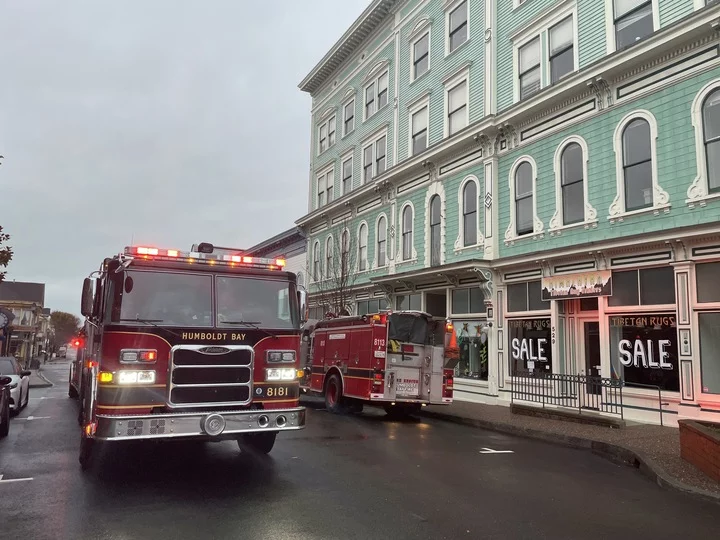
When the transformer blew near Grocery Outlet, plummeting Old Town and much of downtown into dusky dimness (see below), some unlucky soul inside the old Vance Hotel building got trapped inside the elevator.
Two Humboldt Bay Fire units responded to the scene and began working to extract said human. Their efforts were soon rendered unnecessary when the power returned. Paramedics carried one person downstairs on an EMT backboard, though she appeared alert and not in distress.
— Ryan Burns
###
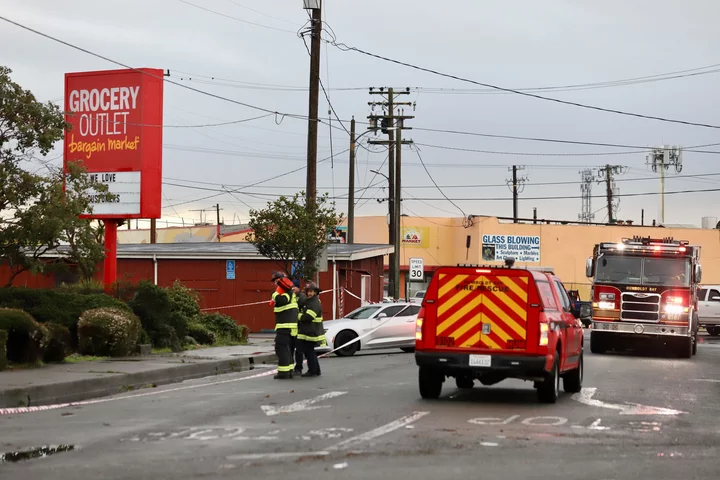
UPDATE, 4:23 p.m.:
Photo: Andrew Goff.
PG&E is at the scene of the Grocery Outlet fizzle-out. This seems like the kind of thing that should be fixed pretty quick, right?
[UPDATE, 4:30 p.m.: Indeed, it is back now.]
— Hank Sims
###
UPDATE, 4:07 p.m.: Watch Transformer Go Boom
Over on the Humboldt County On Alert Facebook page, someone got video of the electrical oopsie that has taken out power to downtown Eureka.
[UPDATE: They’ve since removed it. Oh well! It showed some wires sizzling and fizzling out near Grocery Outlet, over on Sixth Street.]
— Hank Sims
###
UPDATE, 3:54 p.m.: Old Town Power Out
Yikes! Isn’t quite showing up in the LoCO system yet, but all of Old Town has gone dark.
— Hank Sims
###
UPDATE, 3:17 p.m.: Evacuation Orders Issued For Low-Lying Areas Around Eel River Delta
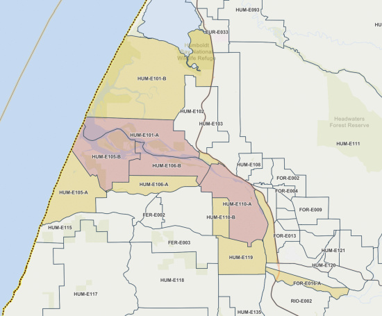
Due to the threat of flooding, the Humboldt County Sheriff’s Office has announced new evacuation orders and warnings for a number of zones surrounding the mouth of the Eel River. They are as follows:
🔴 EVACUATION ORDERS 🔴
Residents in zones with evacuation orders should evacuate immediately. The Humboldt County Sheriff’s Office has issued an Evacuation Order for the following zones:
- HUM-E105-B: north of Riverside Rd./Dillon Rd., south of Cockrobin Island Rd./Cannibal Island Rd., east of Riverside Rd., west of Nissen Ln./Dillon Rd.
- HUM-E101-A: north of Eel River, south of Cannibal Island Rd., east of Pacific Ocean, west Eel River Dr./Hawks Hill Rd.
- HUM-E106-B: north of Goble Ln., south of Cockrobin Island Rd., east of Nissen Ln, Dillon Rd., north of Eel River Dr, State Highway 271.
- HUM-E110-A: north of Pleasant Point Rd/Grizzly Bluff Rd, south of Redwood Hwy, east of State Highway 271/Waddington Rd., west of Riverwalk Dr./Dinsmore Dr.
🟡 EVACUATION WARNINGS 🟡
Additionally, an Evacuation Warning has been issued for the following zones:
- HUM-E101-B: north of Cannibal Island Rd., south of Phelan Rd., east of Cannibal Rd, west of Redwood Hwy/Hawks Hill Rd.
- HUM-E105-A: north of Centerville Rd., South of Riverside Rd., east of Pacific Ocean, west of Port Kenyon Rd./Riverside Rd.
- HUM-E106-A: north of Port Kenyon Rd., south of Goble Ln., east of Port Kenyon Rd./Riverside Rd., west of State Highway 271/Goble Ln.
- HUM-E107: north of Fernbridge/Singley Bar Rd., south of Singley Rd., east of Singley Bar Rd., north of Fernbridge/Redwood Highway.
- HUM-E110-B: north of Grizzly Bluff Rd., south of Pleasant Point Rd., east of Waddington Rd., west of Pleasant Point Rd.
- HUM-E119: north of Price Creek School Rd., south of Grizzly Bluff Rd., east of Regli Ln., west of East Ferry Rd./Sandy Prairie Rd.
- FOR-E012: north of Fowler Lane/Sandy Prairie Road/Redwood Highway, south of Redwood Highway, east of Drake Hill Rd., west of Redwood Highway.
- FOR-E016-A: north of Riverbar Rd., south of Demello Rd., east of US Highway 101/Sandy Prairie Rd, west of Riverbar Rd./Rocky Ln.
- HUM-E138-B: Grizzly Creek Campground/State Park area.
- ARC-E001-B: north of Lamphere Rd., south of Fischer Ave./Mad River Rd., east of Pacific Ocean, west of Miller Ln/US-101 N/Mad River Rd.
- HUM-E033-B: north of Mad River Rd., south of School Rd./Stapp Rd., east of Pacific Ocean, west of US-101.
Residents should remain ready to evacuate at a moment’s notice if conditions worsen. Residents are advised to prepare for potential evacuations, including gathering personal supplies and overnight accommodations. More information will follow if an Evacuation Order is issued.
EVACUATION CENTER
The Humboldt County Sheriff’s Office of Emergency Services in coordination with the Humboldt County Department of Health & Human Services and the American Red Cross-Gold Country Region today established an Evacuation Center for those impacted by the storm. The Evacuation Center is located the Fortuna Firemen’s Pavilion, located at 9 Park St. Fortuna, CA 95540. The center will be open today, Thursday, Nov. 21 at 4 p.m. while community needs are assessed.
— Andrew Goff
###
UPDATE, 1:49 p.m.: Don’t Believe in Fernbridge Staying Open
File photo: Andrew Goff.
Myles Cochrane, Caltrans public information officer, tells us that the agency’s rule of thumb is to shut down traffic on the bridge when the river level reaches 22 24 feet. In other words: Pretty likely, given that the river is forecast to reach 25 feet by tomorrow midday.
[UPDATE, Friday morning: Caltrans calls to make the correction noted above.]
Cochrane said that it’s not so much that the bridge gets flooded when the river reaches that level — it’s just that the road will be impassible on the Ferndale side. You could cross the bridge from this side of the river, but there would be nowhere to go.
— Hank Sims
###
UPDATE, 12:32 p.m.: Eureka Opening Extreme Weather Shelter Again
They didn’t activate the extreme weather shelter protocol last night, but they are doing it tonight, in light of rains
Again: If you need a roof over your head in Eureka tonight, be at one of these places at the indicated time…
- Eureka Free Meal: 6 p.m.
- The Sacco Amphitheater, near the Adorni Center: 6:30 p.m.
- Hope Center (2933 H Street): 7 p.m.
- 14th and Koster: 7:30 p.m.
… and city workers will show up and drive you to the shelter.
— Hank Sims
###
UPDATE, 10:15 a.m.: DAY THREE: Today is Rain Day; Road Chaos; Moderate to Major Flooding Expected in the Eel River Delta Tomorrow
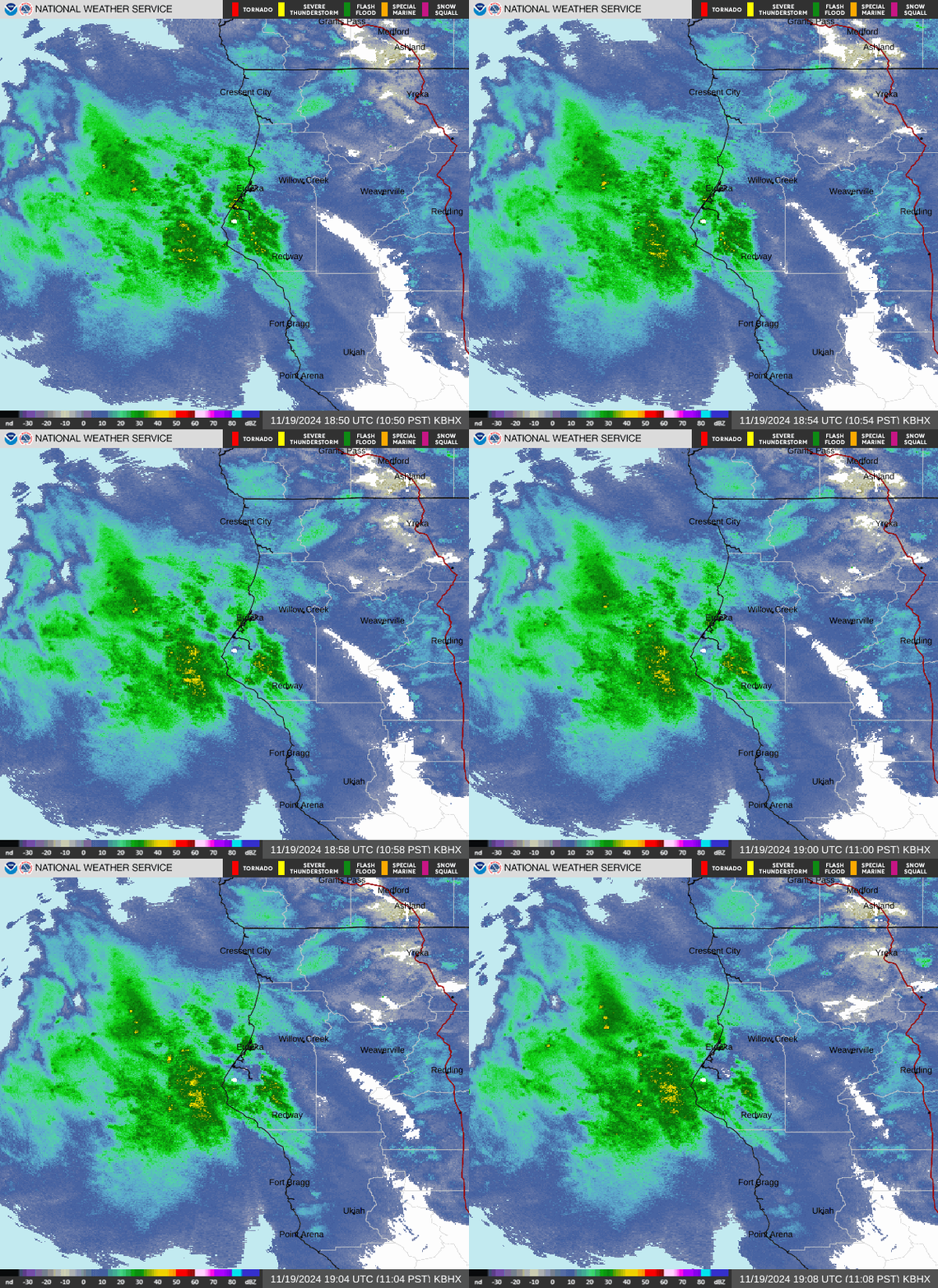
We’re on the third day of this thing, and the skies look to be opening up. The National Weather Service says that heavy rain is imminent, according to the Doppler radar, with several more inches expected to day.
This is going to lead to some sort of flooding, both in localized low-lying areas and in our major rivers. Perhaps of greatest concern: The NWS now estimates that the Eel River will crest at just over 25 feet near Fernbridge. This will happen tomorrow (Friday) at noon.
Twenty-five feet is big. It could well lead to the closure of Fernbridge, and the Eel River Delta will be swamped. Ranchers out near Loleta, along Cannibal Island Road, are going to have to figure out what to do with their cattle.
Meanwhile, the rains are already causing havoc with the road system. The Avenue of the Giants near Holmes is closed due to flooding. Highway 36 is open only to one-way controlled traffic near Pamplin Grove, and again at Bridgeville. There have been several scary-sounding crashes on Highway 101.
The worst is yet to come. Maybe you want to cancel that trip, if you can. Stay at home, snuggle up.
— Hank Sims
###
UPDATE, 11:17 a.m.:
With the storm, sadly, comes the first big Rio Dell sewage overflow incident of this weather year.
— Hank Sims
###
UPDATE, 10:36 a.m.: The Big Rains Have Been Delayed Somewhat
Back on Monday, it looked like today was going to be the big day for rain. Wind Tuesday, rain Wednesday through Saturday — that was the thought.
But now the National Weather Service forecasters are now saying that tomorrow — Thursday — is looking to be the big rain day, and that the southern part of the county, down into Mendocino, is going to bear the brunt of it.
Why?
Meteorologist James White, in the NWS’s Woodley Island Office, tells the Outpost that the late-breaking formation of another low-pressure system has altered the equation somewhat. These two systems are dancing around each other in a sort of foxtrot that the weather scientists have name “The Fujiwhara Effect.”
This has altered the course of events a little bit.
We’re still forecast to get a good amount of rain around Humboldt Bay, White says — probably something in the 6-8 inch range between now and Saturday — but the main brunt of the storm has been pushed to the south.
Also: There will be a second round of high winds from that late-to-the-scene low pressure system, but nothing like as strong as it was yesterday.
That’s the state of play as of now!
— Hank Sims
###
UPDATE, 10:24 a.m.: Some Light Carnage
It seems safe to say, that Humboldt endured night one of the bomb cyclone with relative ease. Poking around social media reveals that some cosmetic damage befell our community, though. Winco is now Wino (see above). Savage Henry lost its tree (see below).
More dire: The Sanctuary in Arcata has had a rough morning sopping up water off their floors after a portion of their roof blew off. They are seeking assistance. Details in the clip below:
— Andrew Goff
###
UPDATE, 4:13 p.m.: Power Outage in Fieldbrook
Approximately 1,893 PG&E customers living in and around Fieldbrook lost power around 2 p.m.
— Isabella Vanderheiden
###
UPDATE, 3:24 p.m.: Is Your School Closed?
As part of its all-around “alerts” system — find that at this link — the Humboldt County Office of Education is curating a Google Spreadsheet that will have information about weather- or power-related school closures around the county during the course of this storm.
You can find that Google Spreadsheet right here.
— Hank Sims
###
UPDATE, 2:20 p.m.: And So It Begins
1,500 customers without power in Westhaven/Trinidad/Sue-meg.
— Hank Sims
###
UPDATE, 2:12 p.m.: Warming Shelter Opens Tonight in Eureka
This is going to be a bad night to not have a roof over your head.
The City of Eureka has activated its overnight warming shelter protocol. If you’re without a home tonight — or know someone who will be — here’s what you need to do.
Meet up with service workers at these times and in these places:
- Eureka Free Meal: 6 p.m.
- The Sacco Amphitheater, near the Adorni Center: 6:30 p.m.
- Hope Center (2933 H Street): 7 p.m.
- 14th and Koster: 7:30 p.m.
They’ll transport you to the overnight shelter. Stay dry, everybody.
— Hank Sims
###
UPDATE, 12:55 p.m.: Well, the Weather Outside is Frightful…
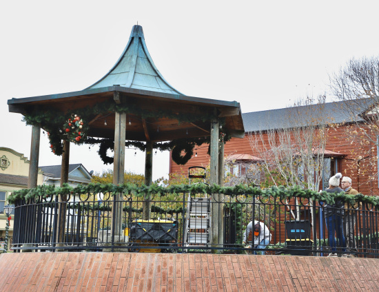
While Humboldt waits for the “bomb” to drop, City of Eureka employees were undeterred in preparing Old Town for the coming holiday season. On Tuesday morning, crews could be seen decorating the Old Town Gazebo and its surrounding plaza in advance of the official Mayor’s Holiday Lighting Fundraising Campaign event scheduled for this afternoon.
“The show must go on,” city employee Swan Asbury told us when we commented on the timing of the decoration efforts. Bomb cyclone be damned. Eureka will have its Christmas.
— Andrew Goff
###
Graphic: Eureka NWS
###
Batten down the hatches, Humboldt!
Over the next few days, a powerful atmospheric river – or “bomb cyclone” – will bring an onslaught of wind and rain to the North Coast, with most areas seeing between three and six inches of rain between now and Wednesday, according to the National Weather Service’s office in Eureka.
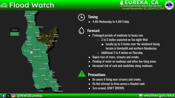
“A major atmospheric river storm is forecast to bring periods of heavy rain and the potential for major flooding in urban and rural areas late tonight through Friday,” according to a Flood Watch issued this afternoon. “Small creeks and streams will rapidly rise and may come out of their banks. More extensive flooding, including flooding of main stem rivers, is forecast later in the week.”
There is a Flood Watch in effect for the Eel River at Fernbridge and other low-lying areas of the Eel River Valley. “Significant flooding of the western portions of Cannibal Island Road, Camp Weott Road, the Salt and Old Rivers, and all adjacent low-lying areas,” according to NWS. “Owners of livestock should consider taking appropriate action to protect livestock.”
Graphic: Eureka NWS
There is also a High Wind Warning in effect for the next 24 hours. Folks living in the interior areas of the county can expect south winds ranging between 30 to 40 mph, with gusts up to 70 mph expected. Expect power outages throughout the region.
You can find a list of active weather alerts from the National Weather Service at this link. Your LoCO will keep this post updated with current weather conditions, road closure information, power outages and other helpful links.
As we wait for this so-called bomb cyclone to make landfall, you might want to take the time to charge up all of your devices (including backup batteries) in case of a power outage. It’s also a good idea to have plenty of water and non-perishable food handy.
Need sandbags? The Humboldt County Office of Emergency Services has complied a list of where to get sandbag supplies throughout the county:
Bags and sand:
• Hensell Materials, 4475 Broadway in Eureka (bags and sand available)
• Randall Sand & Gravel, 214 West River Ln. in Garberville (bags and sand available)Sand only:
• Eureka Ready Mix, locations in Arcata, Eureka, Alton and Blue Lake (sand only, no bags available)
• Kernan Construction, 1195 Hatchery Rd. in Blue Lake (sand only, no bags available)
• Mercer Frasier, 200 Dinsmore Dr. in Fortuna (sand only, no bags available)
• Powell Landscaping Materials, 1955 Hilfiker Ln. in Eureka (sand only, no bags available)
• Miller Farms Nursery, 1828 Central Ave. in McKinleyville (sand only, no bags available)Bags only:
• Nilsen Feed, 1593 Market St. in Ferndale (bags only, no sand available)
• Dazey’s Supply, 690 Thomas Dr. in Garberville and 5307 Boyd Rd. in Arcata (bags only, no sand available)
• United Rentals, 3132 Jacobs Ave in Eureka (bags only, no sand available)
• Root 101 Nursery, 350 Sprowl Creek Rd. in Garberville (bags only, no sand available)
• Pierson Building Center, 4100 Broadway in Eureka (bags only, no sand available)
• McKinleyville Community Services District, 1656 Sutter Rd. in McKinleyville (bags only, no sand available)We have also confirmed that sandbags are available at the following city locations, free of charge:
Free supplies are intended for residents of the incorporated cities listed below and are available in limited quantities, while supplies last. Residents are encouraged to bring their own shovels to fill bags.
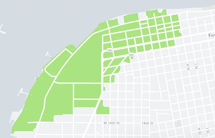
• City of Eureka Corp Yard at 945 W 14th St., available anytime
• City of Arcata Corp Yard at 600 South G. St., available anytime
• City of Ferndale at the Francis Street Bridge on Francis St., available anytime
• City of Fortuna, behind the skating rink at Rohner Park located at 9 Park St., available anytime
• City of Rio Dell, behind City Hall at 675 Wildwood Ave., available anytime
• Blue Lake City Hall at 111 Greenwood Ave., available anytimeHow to fill and place sandbags:
Check out this video from the California Department of Water Resources on how to fill and place sandbags: www.youtube.com/watch?v=5fa8ApB_TFc
Storm season preparedness tips:
Be sure to keep your essential devices and phones charged in the event of power outages. To learn more on how to prepare for a power outage or for more winter storm season preparedness tips, visit: www.listoscalifornia.org/stormseason/
Stay safe out there, Humboldt!

CLICK TO MANAGE