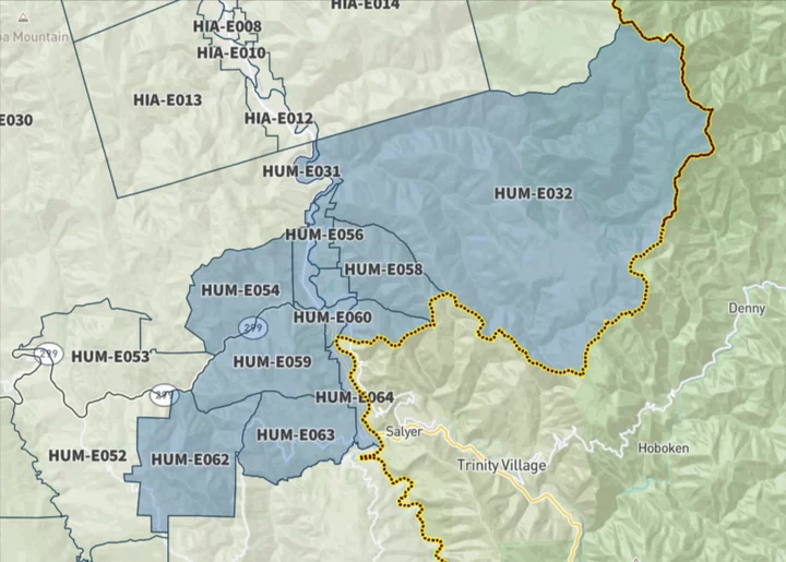
EVACUATION WARNING is being issued for zones HUM-E063, HUM-E064, and HUM-E077-B, south/southeast of Willow Creek. Prepare for potential evacuations, including personal supplies and overnight accommodations. Be ready to go at a moment's notice. (2/2)
#EVACUATION ORDER: Due to wildfire, an immediate EVACUATION ORDER is being issued for zones HUM-E058 and HUM-E061, east of Willow Creek. Residents in these zones should evacuate now. There is no immediate threat to Willow Creek proper. (1/2) pic.twitter.com/HhHuEQH1E1
#EVACUATION ORDER: Due to wildfire, an immediate EVACUATION ORDER is being issued for zones HUM-E058 and HUM-E061, east of Willow Creek. Residents in these zones should evacuate now. There is no immediate threat to Willow Creek proper. (1/2) pic.twitter.com/HhHuEQH1E1
OAK: Approx. 8-18 acres. Fire is located south of Willow Creek. Near FS Road 5N31 and 6N20.
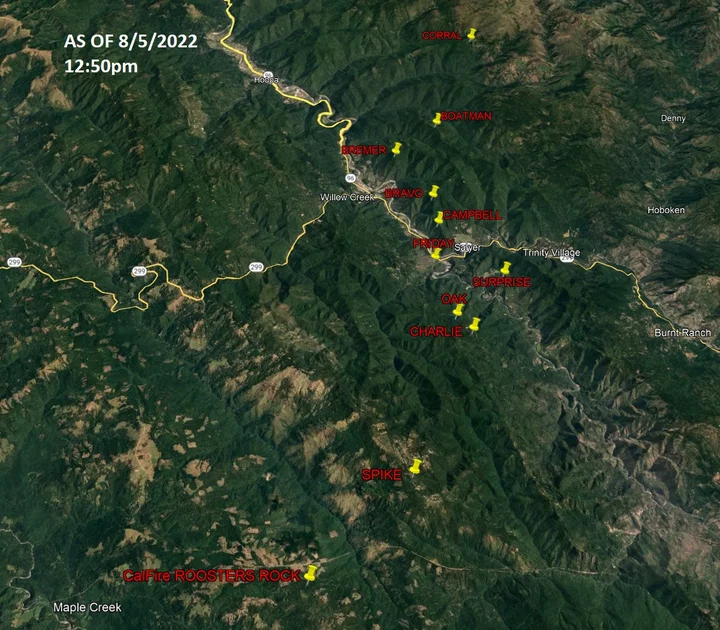
CORRAL: Fire is located northeast of Willow Creek on Tish Tang Ridge.
CEDAR: Fire is located 3.5 miles north Denny.
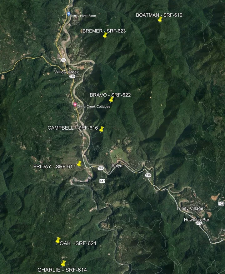
BOATMAN: Fire is located northeast of Willow Creek on Waterman Ridge Road 7N02 Forest Route 4.
BREMER: Approx. 20 acres. Fire is located northeast of Willow Creek on ridgetop above the Bigfoot Subdivision. No road access to fire. Currently staffed with 3 engines on top and 2 engines at bottom.
BRAVO: Approx. 10-12 acres. Fire is located south of Willow Creek between Baldwin and Campbell Ridge.
CAMPBELL: Approx. 30-40 acres. Fire is located south of Willow Creek on the west side of Campbell Ridge above Campbell Ridge Road.
FRIDAY: Fire is located south of Willow Creek ½ mile up Friday Ridge Rd from Hwy 299.
SURPRISE: Fire is located approximately 3 miles south of Salyer on South Fork Road.
OAK: Fire is located south of Willow Creek. Near FS Road 5N31 and 6N20.
CHARLIE: Approx. .5 acres. Fire is located south of Willow Creek near the Oak Fire and along FS Road 6N20.
SPIKE: Approx. 1/10th acre. Fire is located approximately 10 miles South of Hwy 299 on Forest Route 1 near Spike Buck Mountain.
ROOSTER ROCK. Fire is being managed by CalFire. Located east of Maple Creek, near Rooster Rock and Snow Camp Mountain.
unofficial / 3:45 p.m.
Blue Lake TC motorcycle vs deer, 6600 block Maple Creek Rd, male victim is down & in altered condition; for Blue Lake Fire & Arcata Amb
Going Down @ 2:47 p.m.
Here’s the latest update — below — on the Willow Creek fires from the Humboldt County Office of Emergency Services’ Facebook page.
Takeaway for the Facebookless: HumOES is introducing a new term — “Wildfire Advisory” — to describe what they’re doing, here, apparently to avoid confusion with evacuation warnings and orders.
What does that mean? OES explains:
Residents under a WILDFIRE ADVISORY are asked to unlock gates and begin reviewing their evacuation plans/checklist. Create your emergency plan at this link.
Residents are also encouraged to take this time to create defensible space around your property BEFORE evacuation notices are issued. Defensible space is the buffer you create between a building on your property and the grass, trees, shrubs or any wildland area that surround it. This space is needed to slow or stop the spread of wildfire and it helps protect your home from catching fire—either from embers, direct flame contact or radiant heat. Proper defensible space also provides firefighters a safe area to work in, to defend your home.
Going Down @ 2:35 p.m.
Where is Guffman?
Friends of a local visually impaired woman write in to report that Guffman, their friend’s seeing-eye dog, went missing yesterday in Arcata.
“I am blind and he is my eyes,” reads the post by Juliannah Harris on Humboldt Paws Cause announcing Guffman’s lost status. “Check backyards. He doesn’t bark.
Guffman is a black lab and was last seen around noon on Thursday, Aug. 4 on Iverson Avenue in Arcata. If seen, folks are asked to call 707-499-3972.
Going Down @ 1:37 p.m.
Six Rivers National Forest has now tallied 10 wildfires burning since last night’s lightning storm in the Willow Creek Area. Here’s their latest info.
For those without Facebook:
BOATMAN: Fire is located northeast of Willow Creek on Waterman Ridge Road 7N02 Forest Route 4.
BREMER: Fire is located northeast of Willow Creek on ridgetop above the Bigfoot Subdivision. No road access to fire. Currently staffed with 3 engines on top and 2 engines at bottom.
BRAVO: Fire is located south of Willow Creek between Baldwin and Campbell Ridge.
CAMPBELL: Fire is located south of Willow Creek on the west side of Campbell Ridge above Campbell Ridge Road.
FRIDAY: Fire is located south of Willow Creek ½ mile up Friday Ridge Rd from Hwy 299.
OAK: Fire is located south of Willow Creek. Near FS Road 5N31 and 6N20.
CHARLIE Fire is located south of Willow Creek near the Oak Fire and along FS Road 6N20.
SURPRISE: Fire is located approximately 3 miles south of Salyer on South Fork Road.
SPIKE: Fire is located approximately 10 miles South of Hwy 299 on Forest Route 1 near Spike Buck Mountain.
CORRAL: Fire is located northeast of Willow Creek on Tish Tang Ridge.
ROOSTER ROCK. Fire is being managed by CalFire. Located east of Maple Creek, near Rooster Rock and Snow Camp Mountain.
BOATMAN: Fire is located northeast of Willow Creek on Waterman Ridge Road 7N02 Forest Route 4.
BREMER: Fire is located northeast of Willow Creek on ridgetop above the Bigfoot Subdivision. No road access to fire. Currently staffed with 3 engines on top and 2 engines at bottom.
BRAVO: Fire is located south of Willow Creek between Baldwin and Campbell Ridge.
CAMPBELL: Fire is located south of Willow Creek on the west side of Campbell Ridge above Campbell Ridge Road.
FRIDAY: Fire is located south of Willow Creek ½ mile up Friday Ridge Rd from Hwy 299.
OAK: Fire is located south of Willow Creek. Near FS Road 5N31 and 6N20.
CHARLIE Fire is located south of Willow Creek near the Oak Fire and along FS Road 6N20.
Going Down @ 10:25 a.m.
Here’s the live, zoomable map of areas under an evacuation advisory at this time.
An “evacuation advisory” is a level below “evacuation warning” and two levels below “evacuation order.” The advisory is meant to put people in these areas on alert that those further, more serious steps could soon be taken.
UPDATE: If you’re having problems seeing the Zonehaven map above on your phone, here’s a direct link. And below is a screenshot of the information as of this writing.
Going Down @ 10:06 a.m.
ADVISORY: Due to #wildfire activity, the @HumCoSO is issuing an ADVISORY for the Willow Creek area. There are no evacuation orders or warnings at this time. Please open locked gates for fire personnel access and be ready to go at a moment’s notice. https://t.co/H5fp6aMyU0pic.twitter.com/7wHFZZ9z84
A thunderstorm passed through Humboldt County last night, lighting up the dry terrain in the hills. Scroll down for real-time reports from “Unofficial,” a valued member of our “Scanner Traffic Indicates” corps. And find, below, video taken by friend of the LoCO Joel Rosser from his McKinleyville-area vantage.
There are reports of several fires in the Willow Creek area on Facebook’s Willow Creek, CA Bulletin Board, though it’s unclear at this writing if they’re threatening to blow up out of control. We’ll have more information as the day progresses.
Hoopa OES is reporting all clear as of about an hour ago:
unofficial / 2:57 a.m.
Brannan Mtn area: request Willow Creek Fire to check for any lightning strikes problems in the area around Brannan Mountain
unofficial / 1:41 a.m.
Westhaven Engine 8411 returned to their quarters from the Upper Creek fire
unofficial / 1:12 a.m.
Upper IC reporting Arcata Fire personnel being released but to hold the Fieldbrook engine until they get back and become available
unofficial / 1:03 a.m.
Loleta Engine 7515’s been released from the Upper Incident, returning to their quarters
unofficial / 12:53 a.m.
Arcata PD ofcr canceling ambulance from the Blakeslee Ave call
unofficial / 12:50 a.m.
Arcata TC poss w/injuries, 1800 block Blakeslee Ave; for Arcata Amb, Fire and Police
unofficial / 12:28 a.m.
HumBayFire Battalion 8102 and Engine 8115 released from the Upper Incident and returning to their stations


CLICK TO MANAGE