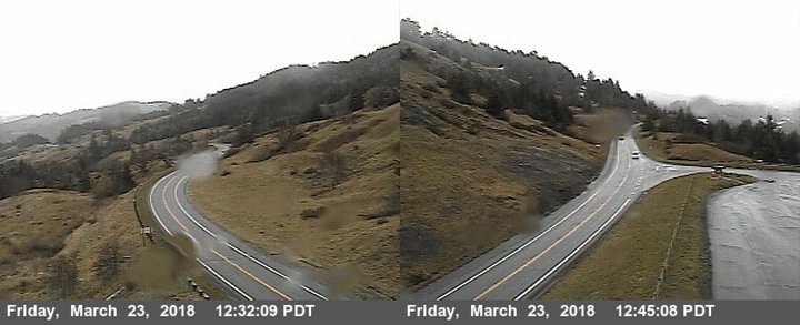
Berry Summit doesn’t know what’s about to hit it. Photos: Caltrans traffic cameras.
The next storm is almost upon us!
The National Weather Service office on Woodley Island is putting out the alarm — there’s a front headed this way, and it’s going to be a cold one, and it’s going to be a wet one.
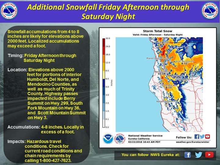
Forecasters are predicting that snow will start impacting local highway passes — including Highway 299’s Berry Summit and Highway 36’s South Fork Mountain — this evening. The Winter Weather Advisory issued by the NWS this morning predicts that two to four inches of snow will stick in most places, with chances of deeper drifts elsewhere.
Will this mean chain controls or even closures on mountain roads? It’s possible.
On the coast, we’re supposed to expect rain and possible thunderstorms and/or hail this evening, as per a new Hazardous Weather Outlook, with the possibility of more of the same continuing through Thursday.
Below: Winter Weather Advisory for the Del Norte/Humboldt Interior:
Del Norte Interior-Northern Humboldt Interior- Southern Humboldt Interior
1051 AM PDT Fri Mar 23 2018
WINTER WEATHER ADVISORY IN EFFECT FROM 5 PM THIS AFTERNOON TO 2 AM PDT SATURDAY ABOVE 2500 FEETWHAT…Snow expected. Plan on slippery road conditions, including during the evening commute. Total snow accumulations of 2 to 4 inches, with localized amounts up to 7 inches, are expected.
WHERE…Del Norte Interior, Northern Humboldt Interior and Southern Humboldt County Interior. Highways impacted include Hwy 299, 199, and 36.
WHEN…5 PM today to 2 AM Saturday.
ADDITIONAL DETAILS…Slow down, allow extra time and be prepared for changing conditions. Check the latest forecasts and call 1-800-427-7623 for current road conditions and chain requirements before traveling. Be alert for rock slides in mountainous terrain.
PRECAUTIONARY/PREPAREDNESS ACTIONS… A Winter Weather Advisory for snow means periods of snow will cause primarily travel difficulties. Be prepared for snow covered roads and limited visibilities, and use caution while driving.
For a detailed view of the hazard area visit: http://www.wrh.noaa.gov/map/?wfo=eka
CLICK TO MANAGE