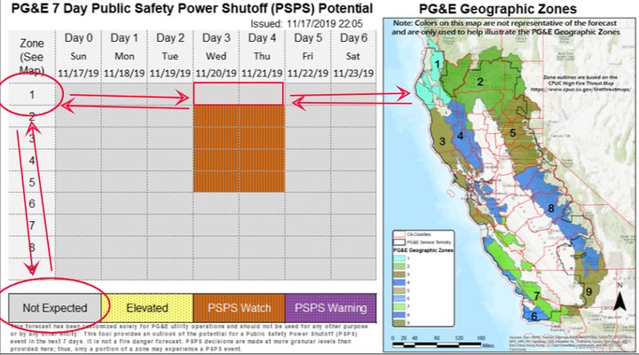
PG&E map of the potential public safety power shutoff that could hit on Wednesday and Thursday, as of Monday morning. Source here.
###
Over the weekend, Pacific Gas and Electric — the utility that sometimes provides electricity to Humboldt County and other places in California — announced that it was keeping an eye on a weather system developing off the coast that might trigger another “public safety power shutoff” of the type that blacked out all of Humboldt County twice last month.
This morning, the company upgraded the threat level of this potential shutdown from “elevated” to “PSPS watch” — making the eventuality of a widespread power shutoff starting Wednesday or Thursday more likely.
However, having been through this cycle three times now, the Outpost thinks it knows enough to know that Humboldt County does not appear, at the moment, to be in the shutdown’s path. We say this with the usual provisos: The weather is subject to change, and PG&E could be mistaken about the layout and capability of its own grid.
We understand why — despite the seemingly clear map above — some Humboldt people are already knuckling down for another blackout. The first time this happened, back on Oct. 9, PG&E thought that coastal Humboldt County, being not in danger of fire, would not have to be blacked out, only to realize at the last minute that our power plant is connected to the main grid through two transmission lines that pass through the tinderbox of the forests to our east to the Central Valley. At the last minute, the utility remembered this and put all Humboldt on the shutdown list as well.
So does PG&E forget this time, too? We think not. The next time a PSPS touched our shores, on Oct. 26, the company had done some boning up on which power lines run where, and Humboldt received plenty of advance warning.
The map PG&E is publishing at the moment most closely resembles the map of the third PSPS event we all went through on Oct. 29 — the one that never actually came, except for a tiny corner of the county along the Highway 36 corridor. That corner, it appears, ties into a different section of the grid than the rest of us do, and if you squint you can see it in the current map (above), where a little sliver of green crosses the light red county line.
The rest of the county stayed up throughout the Oct. 29 PSPS, even though wide swaths of the rest of the state went down, because changing weather conditions meant that the company didn’t have to take down the power to one or both of the transmission lines into Humboldt County after all.
So it seems that that’s the scenario that PG&E is currently looking at this time around — power outages to much of the state, but the lights will stay on in all but that one very small corner of the county.
Could the weather change, and this forecast change with it? Yes. Could PG&E have screwed up again and re-forgotten that it’ll have to shut us down because of the transmission lines? You know very well that it’s a possibility.
As of now, though, and because we saw PG&E get more sophisticated in its understanding of its own infrastructure throughout the course of last month, we believe that the map it has published reflects reality, more or less — it represents the areas of the state that are, as of the current moment, at risk of being deactivated during public safety power shutdown this Wednesday and Thursday.
We’ll keep you updated if that changes!
CLICK TO MANAGE