National Weather Service
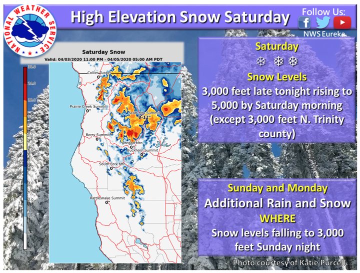
The National Weather Service is forecasting snow starting at around 11 p.m. this evening and continuing through until about 5 a.m. on Sunday morning.
Yesterday the NWS tweeted out that more than seven inches of snow is expected in parts of northern Trinity County starting at about 3,000 feet in elevation. In lower elevations, hail and isolated thunderstorms are forecast for Saturday through Monday, mostly occurring in the afternoon.
The wintery weather can make for hazardous conditions on some of the higher elevation roads and passes in the area, but we’re all supposed to be staying at home and why leave the house when you can watch Tiger King on Netflix?
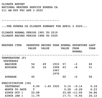
Humboldt County is currently experiencing moderate drought conditions and so although the cooler temps may be a bummer, the moisture is needed to help from slipping into more severe drought conditions. According to the National Climate Data Center, Humboldt County has received 22.68 inches of precipitation from Oct. 1, 2019; 11 inches short of the normal amount of 33.68 inches.
National Climate Data Center numbers
The incoming storm is forecast to bring anywhere from 1.5 to 2.25 inches of precipitation before breaking up and making for a few days of partly cloudy skies starting Tuesday.
So stay hunkered down and enjoy this haiku:
Winter weather comes
Tonight with cold rain and snow.
Be calm and stay home.
CLICK TO MANAGE