Overview of the boundaries of the Six Rivers Lightning Complex as of the morning, with individual fire names.
Press release from the Six Rivers National Forest:
Six Rivers National Forest Crews working the fires last night were able to hold a majority of the work accomplished by the day shift. High overnight humidity helped slow any progress. The incident will enter into unified command with Cal Fire at 7:00 am today. Additionally, the Trinity County Sheriff’s Department, Humboldt County Sheriff’s Department, California Highway Patrol and CalFire are also in unified command with the Forest Service.
All uncontained fires within the complex continue to have potential to increase in size with uphill runs, moderate range spotting, as well as extreme fire behavior.
Much of the steep and nearly inaccessible terrain has heavy ground fuel accumulations from the winter ice storm which could result in uncharacteristic fire behavior. The active fire area has has little recent fire history
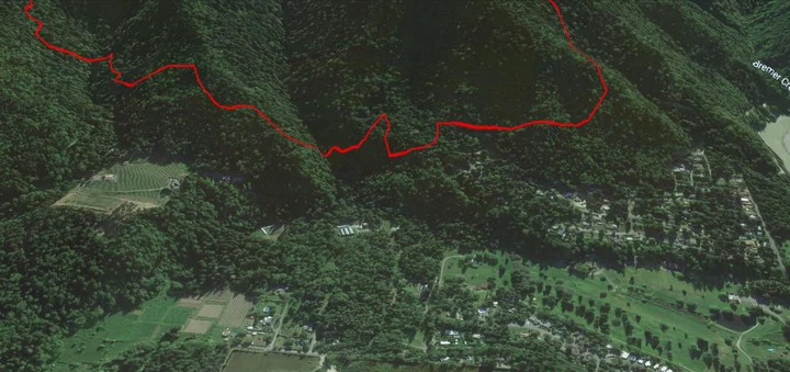
Closeup of the fire boundary, as of this morning, above Willow Creek’s Bigfoot Subdivision. Google Earth/National Interagency Fire Center data.
Given the full-suppression tactics on this fire, crews will continue to fight fire aggressively in order to keep fire as small as possible. Personnel are working to find areas to fight fire directly while continuing to provide community defense for Willow Creek, Seely, Mcintosh, Salyer Heights and other areas along the Trinity River.Thanks to the hard work of many firefighter personnel, zero structures have been lost.
Additional crews, engines, and other resources are arriving continually.
Weather:
Smoke and inversion strength will be the main weather drivers across the complex today. Tonight winds are expected to be light with good humidity recovery.
Evacuations:
The fire threatens communities along the Trinity River. Five main fires burn North and South of Highway 299. Primary areas of focus are the communities along the 299 corridor, Waterman Ridge, Friday Ridge Road, and Ammon Ridge.
Evacuations continue around Willow Creek, Friday Ridge, Salyer and Trinity Village. Additional fire growth could impact communities and residences along the Route 1 road. To find the latest evacuation information go to Humboldt County Office of Emergency Services (https://humboldtgov.org/2383/) or Trinity County Office of Emergency Services (https://www.trinitycounty.). Evacuation zones can be found at https://community.zonehaven. If you are under an evacuation warning, take the necessary steps to be ready to leave.
Evacuation Center:
American Red Cross
Trinity Valley Elementary School
730 Highway 96, Willow Creek, CA 95573Animal Evacuation Center:
Hoopa Rodeo Grounds
1767 Pine Creek Rd., Hoopa, CA 95546
(707) 492-2851**The Hoopa Rodeo Grounds has several single pens and larger pens for whole herds. Call directly if you need directions or help transporting your large animals. They cannot house sheep, goats, poultry, or small animals, but they can potentially help arrange for temporary foster placement. If you can foster, please reach out regarding your availability and capacity.
Road Closures:
State Route 299, State Route 96, and Route 1 remain open to through traffic. Residents are encouraged to visit http://quickmap.dot.ca.gov/ to check for state highway closures.
The following roads into evacuation zones have been closed. Residents may still use these roads to travel out of evacuation order zones:
Horse Linto Creek Road at Saddle Lane
Country Club Road at Kimtu Bridge
Friday Ridge Road at Hwy 299
Smoke:
Heavy smoke and strong inversions continue to affect the health of those who are not yet evacuated. Please check https://www.ncuaqmd.org for air quality resources.
Incident Information:
For more information on the Six Rivers Lightning Complex go to our Inciweb page at:
InciWeb http://inciweb.nwcg.gov/
Six Rivers National Forest Facebook: www.facebook.com/SixRiversNF
Six Rivers Forest Website: www.fs.usda.gov/srnf
Fire Information Call Center: (707) 356-9442 (8 am-8pm daily)
- email 2022.lightningcomplex@firenet.gov
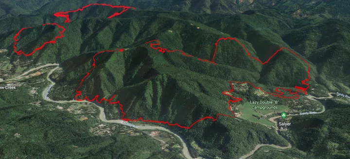
Foreground: The boundaries of Campbell Fire, between Salyer and Willow Creek, as of this morning. Bremer and Cedar/Waterman fires in the background. Google Earth/National Interagency Fire Center data.
CLICK TO MANAGE