
Justin Garwood in the Trinity Alps, fall 2022. Photo: Justin Garwood.
On a sweltering October day in 2022, Justin Garwood tucked a piece of glacial ice into his sleeping bag, carefully arranged clothes around the bundle, hiked 10 miles out of the Trinity Alps and stuck the chunk in his freezer, where it remains today.
“I don’t know what to do with it now,” he admitted.
The Trinities were once home to the lowest altitude, western-most glaciers in California: the Grizzly and the Salmon. But in 2015, after years of severe drought, the Grizzly Glacier broke apart and the Salmon disappeared entirely (or “went extinct,” in science-speak).

The now-extinct Salmon Glacier in the Trinity Alps in 2009 vs. 2015. Photos: Justin Garwood.
And in the fall of 2022 the Grizzly went extinct too.
“A certain climate supports glaciers, and we’ve left that,” said Garwood, an environmental scientist with the California Department of Fish & Wildlife, who described their loss as a “threshold crossed.”
California’s climate has long been “variable” in terms of precipitation (rain and snowfall), meaning swings from bone-dry to drenched-wet are nothing new. But warming is pushing that variability into overdrive, flatting four seasons into two: flood and drought, with drought growing ever longer.
“Some people call it the ‘climate vice,’ things are being put in a vice and squeezed,” Garwood said, “Snow is melting off sooner and coming later, so there’s less water on the landscape.”
An avid backpacker in the Klamath range and subranges (Siskiyous, Trinity Alps and Marbles) and co-editor of The Klamath Mountains: A Natural History, Garwood has been studying the effects of climate change in the mountains for years – as this Backpacker article chronicles. And, having grown up in Lewiston (east of Weaverville, west of Redding, at the edge of the Trinity Alps), he’s seen the region’s precipitation patterns change throughout his lifetime.
“When I was growing up, we used to get some decent snowstorms,” he said, “It wasn’t a big deal if two feet of snow fell at 2000 ft elevation.”
“Today, that’s a big deal,” he added.
Now, Garwood and climate scientist John P. O’Brien (also Trinity County-raised) are working on research that tells the story of the Grizzly’s final years – a sort of epilogue to glacial ice in the Klamath. But Garwood made clear that the disappearance of the glaciers, which were small to begin with, will not affect ecosystems as much as the shrinking of perennial snowfields in the range, such as those at Mirror Lake and Canyon Creek (both of which disappeared during the summers of 2013 and 2014).
“The elephant in the room isn’t the glaciers, it’s the loss of snow,” he said, explaining that the higher-altitude glaciers can be understood as a “canary in the coal mine” for what’s happening further down.
Increasing temperatures at higher altitudes are raising the snow line year by year, curtailing mountains’ abilities to act as ice chests for groundwater that is “metered out,” in Garwood’s words, during the dry summer months. These stores feed the rivers, lakes and reservoirs that provide crucial cold-water habitats for salmon and other species (as well as drinking water and electricity for humans, as O’Brien pointed out).
Melt is also occurring earlier in the year and faster – increasing flood risks during high precipitation years.
“Climate-driven megadrought” in the American West over the last two decades, which has marked the driest period on record in 1,200 years, has raised flood risks as well by making soil, trees and vegetation less able to soak up water.
(Parched landscapes tend more toward erosion and flooding during extreme precipitation events rather than beneficial water capture and retention.)

Vegetation change in the mountains above the Scott River, a tributary that feeds into the Klamath River, after years of drought (left: Dec. 1984, right: Dec. 2019). Images: Google Earth.
And (perhaps obviously), the less moisture gained and retained, the farther the severity and reach of fires will extend as “fuel conditions” (firefighter-speak for grasses, trees, branches and brush) increase in flammability.
“While we may see flooding in parts of the forest during the winter, the vegetation or ‘fuels’ will still dry out during the summer months. It’s not a question of ‘if’ fire will occur but rather ‘when,’” Adrianne Rubiaco, fire public affairs specialist with the Six Rivers National Forest, told the Outpost via email, “This is one of the reasons we are working with our federal, tribal, state, local and private partners to manage landscapes and reduce wildland fuels.”

The Red Salmon Complex Fire burns in the Trinity Alps Wilderness, 2020. Photo: Finn Scott-Neff.
Intensifying cycles of hotter, drier summers and shorter, more storm-filled winters explain why the forested montane areas of Northern California are predicted to experience up to a 400% increase in the average area burned annually by 2100, while the Shasta-Trinity National Forest expects a 300-400% increase in the frequency of 200-year flood events during the same period.
In climate-change-feedback-loop fashion, severe fires further alter water cycles by scorching the land, burning away moisture-absorbing vegetation and layering ash over snow and ice.
The River Complex Fire did just that in 2021, according to Garwood and O’Brien. Climbing the south face of Thompson Peak and burning at a higher elevation than any fire in recorded Klamath history, it rained ash down on Grizzly Glacier – accelerating the mass’s melt.
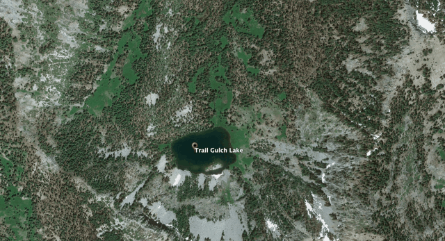
Scarred landscape surrounding Trail Gulch Lake, a popular backpacking spot in the Trinity Alps, after the River Complex Fires burned 199,343 acres in the summer of 2021 (left: July 2017, right: Mar. 2024). Images: Google Earth.
And while on Thompson, the tallest mountain in the Trinities, the River Complex also destroyed an ancient stand of whitebark pine (a federally “Threatened” species under the Endangered Species Act).
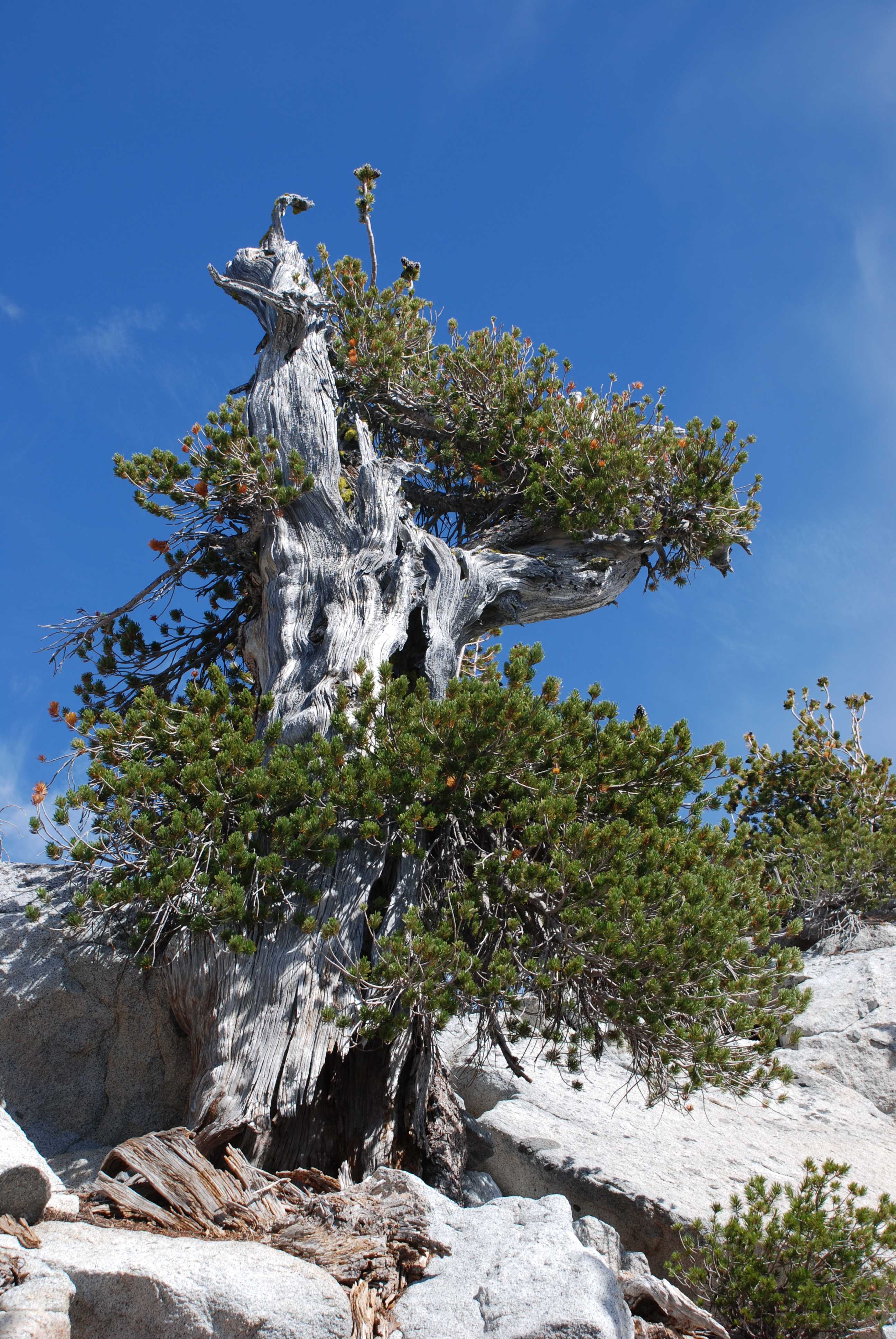
Whitebark pine. Photo: Justin Garwood.
“These are not fire-adapted trees,” O’Brien said, explaining that because they grow at high elevations, whitebark pine haven’t had to face fire and lack the thick bark armor that protects their lower-altitude compatriots like redwoods and Douglas fir.
“The loss of this ancient subalpine stand is another local indicator of rapid climate change,” Garwood added.
Best practices for managing the cycles of extreme precipitation and hotter, drier summers that climate change is causing in the Klamath do not aim to stop fires entirely. On the contrary, prescribed burning has been known to decrease the severity of fires and has been carried out by the Karuk Tribe for thousands of years.
“Conducting prescribed burning on public land can release less volatile smoke and ash and reduces the potential risk to firefighters and people living in rural communities,” said Finn Scott-Neff, a lead forestry technician with a hotshot/handcrew out of Salyer.

The Red Salmon Complex Fire burns in the Trinity Alps Wilderness, 2020. Photo: Finn Scott-Neff.
While rains may have provided some respite from drought these last two winters, the loss of ice in the Klamath Mountains serves as a foreboding indicator that the range – and the ecosystems within it, developed alongside now-altered cycles of snowfall and melt – will continue to repay the debt that greenhouse gas emissions have written in California’s ledger during the coming seasons of fire and flood.
“Water has a non-negotiable freezing point. If you don’t get below that, you won’t get snow,” O’Brien said, “Warming temperatures push this ever uphill, every year.”

The Red Salmon Complex Fire burns in the Trinity Alps Wilderness, 2020. Photo: Finn Scott-Neff.
CLICK TO MANAGE