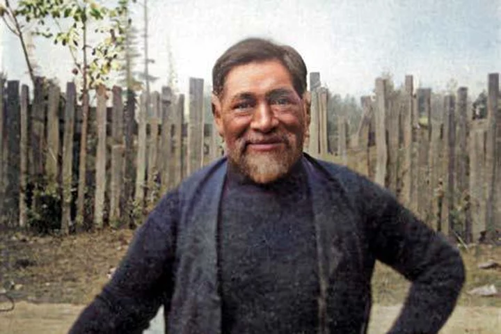
John Stevens, 1910. Photo: Bancroft Library. Colorized by the author.
###
Ed. note: The following is an excerpt from Northern Humboldt Indians, the latest in local historian Jerry Rohde’s book series on the people and places of Humboldt County. It was published earlier this year by the Cal Poly Humboldt Press.
Like all of Rohde’s recent work, the book is published under a Creative Commons license and can be downloaded as a PDF for free. This is amazingly generous. If you’re looking for a beautiful hardcover copy for your shelves or to give to a loved one, you can pick up a copy at various places around town, including from our friends at the Humboldt County Historical Society.
Northern Humboldt Indians tells the stories of the Hoopa, the Yurok, the Wiyot, the Whilkut, the Tsungwe and the Mawenok — the latter of whom, we’d be willing to wager, you’ve never heard of until now — and their encounters with each other, and with the wave of White settlement that overran Native Americans in the mid-19th century.
There’ll be an interview with Rohde posted on the Outpost a couple of hours from now. In the meantime, check out this excerpt, which Rohde gave us explicit permission to reprint.
###
Mawenok Territory
There was a place, on the Mad River, that must have seemed like a world unto itself. To the west the Iaqua Buttes stood like a dark, unscalable wall, rising abruptly from the canyon bottom and extending so high that they blocked the late afternoon sun. On the south was another mountain barrier that also enshadowed the river, while to the north rose a rolling ridgeline punctuated by Chaparral Mountain, Bug Creek Butte, and Board Camp Mountain, all more than 5,000 feet high. Here, however, the mountains descended more gradually to the river, with grassy, south-facing prairies often warmed by the unobstructed sun. On the canyon floor, near the location that became known as Big Bend, it is easy to believe that the river ran through its gorge like a long, sonorous chord, sending its sound to anyone who paused to listen to it, and telling the listeners that here they were welcome to abide, that here, like the river canyon, the spirit ran deep.
It became the home of the Mawenoks.
Almost no one has heard of the tribe. Between 1906 and 1913 three ethnographers interviewed Mawenoks, but they either failed to confirm their tribal identity or did not broadcast their information. In 1918 Llewellyn Loud, in his monograph on the Wiyot tribe, used statements from John Stevens, whom he indicated was born “one and a half to two miles below Maple Creek.” The location was in the heart of Mawenok country, but Loud didn’t know this and he accordingly labeled Stevens a member of the neighboring tribe, the Whilkuts.
Eight years earlier, Stevens had been interviewed by another ethnographer, C. Hart Merriam, who concluded that the Mad River area previously assigned to the Whilkuts had actually been the homeland of a closely connected but separate tribe called the Mawenoks. Merriam obtained a list and descriptions of numerous Mawenok villages without realizing that his informant was himself a member of the tribe, believing, like Loud, that Stevens was a Whilkut. Merriam’s minimal account of this heretofore unknown tribe was not published until 1974 and then only as a paper from the Archaeological Research Facility at UC Berkeley. An even earlier ethnographical inquiry, conducted by Pliny Goddard in 1906 and 1908, included a brief but detailed report about the tribe that still languishes in the deepest obscurity.
In his 1906 interview with Johnnie Maple, he obtained the tribe’s name, spelling it “Me-wi-yi-nuk,” but he apparently never used it in print. A 1908 Goddard interview with Minnie Pete, a Mawenok who was born at Big Bend in about 1850, never mentions her tribal identity, It was first seen by California Athabaskan language expert Victor Golla in 2015, some 107 years after it was recorded. After studying it, Golla concluded that it “is clear that it was recited in a variety of Hupa closely resembling Goddard’s ‘Whilkut.’”
Over time, according to Goddard’s and Merriam’s information, the Mawenoks came to occupy a long stretch of the river, from above Bug Creek on the south all the way downstream to the North Fork Mad. In about 1849 the Mawenoks and their Whilkut neighbors probably joined together in expanding their boundaries by attacking a Wiyot village in the vicinity of later-day Blue Lake. Some Wiyot men were killed, some were driven off, and some of the younger women, whether willingly or not, became wives or partners of the attackers, so that the village subsequently became a combination of Wiyots, Whilkuts, and Mawenoks, along with their mixed offspring.
Upstream from the main Mad River’s confluence with the North Fork, in the area south of Blue Lake, the Mad flows through a heavily wooded canyon that offers little access to the surrounding forest. In the mountains to the east there were two upland Mawenok villages: Ma-kawch-ting at the future site of the Angel Ranch and Yi-kil-le-yah’ng-ahl-ting, on or near Cañon Creek in the prairie area that later became the John Anderson Ranch. Below them, several Mawenok villages occupied small riverside flats at creek mouths. Upstream from Cañon Creek, according to Loud, “there were six villages or camping places, but none of them could boast of having more than two plank houses, or two or three bark houses.” Then came Tse-didis-ten, which “was situated one and a half to two miles below Maple creek.” It “had 10 or 12 houses” and was the birthplace of the Loud and Merriam informant John Stevens.
Above Tse-didis-ten the river twists in a convolution of curves and passes by three large villages located at the mouths of Maple Creek and Boulder Creek and at Blue Slide. Loud reported that
… there were five houses, mostly bark, but some of plank, at the mouth of Maple creek, while on Boulder creek, one and a half miles above Maple creek, there were a considerable number scattered about on both sides of the creek and also up the creek. Hence the Maple creek district was a comparatively populous center.
About a mile above the mouth of Boulder Creek, the Mad makes a C-shaped bend to the west, bumping into a wall of colorful clay called Blue Slide. The flat on the inside of the bend contained what was described as “one of the largest rancherias in the whole Mad river valley.” The Mawenok name for the village was probably Me-meh, but this is not certain.
Above Blue Slide the canyon is again constricted. Some four miles upriver was a village called Sel-ku-mik-kin-ne-din. It was south of what later became the Mountain View Ranch and was situated about a mile west of the river, near the base of the Iaqua Buttes. Another four miles upriver, near the confluence with Wilson Creek, was the village of Lit-tcite-tcin-nouru-din, “sand blows place,” at the location the Whites called Big Bend. The canyon of the Mad opens here, briefly, so that for about two miles south-facing prairielands slope scenically down to the westward-bound river. About a mile farther upstream, near the mouth of Humbug Creek, was the village of Un-tcin-ta-tci-ki. It was a place where Van Duzen Pete, a member of the nearby Nongatl tribe, stayed as a boy.
The Mawenok village farthest up the Mad River was Tseng-nah-neng-ahl-teng, which Merriam reported was “on or near Bug Creek.” At this point the river turns southeast and the already steep-sided canyon narrows into another gorge. At one time there was a landslide in the vicinity of Bug Creek that in dry years formed a barrier to fish migration. The sudden arrival of this obstacle may have caused the Mawenoks to lose interest in the territory upriver from it. In any case, about three miles above Bug Creek, in the vicinity of Deer Creek, was the first village of the Nongatl tribe, which was the Mawenoks’ neighbor to the south.
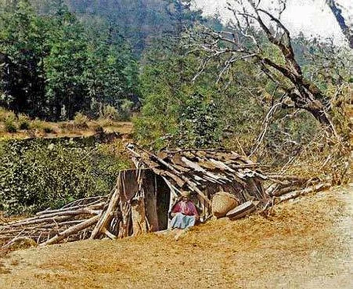
Mawenok traditional house, 1906. The unidentified woman out front is probably Betsey Maple. Photo: Pliny Goddard, via the Hearst Museum of Anthropology. Colorized by the author.
When Pliny Goddard Met Johnnie Maple
In September 1906, Pliny Goddard, one of two professors in the University of California Berkeley’s Anthropology Department, found his way to a remote section of the Mad River, ten miles or so upstream from the town of Blue Lake. He arrived at the flat opposite a wall of clay called Blue Slide, and rode his white horse southward until he reached the homestead of the man he had come to see, Johnnie Maple.
Maple’s cabin and barn were nestled in a gentle curve of hillslope curve that rose eastward from the riverside towards the ranchlands of the Maple Creek area. The structures were built White man’s style, with mill-cut lumber for the sidings and redwood shingles for the roofs. Maple, who was part Mawenok and part Whilkut, lived there with his Mawenok-Wiyot wife Ida, two children, a boarder named Leon, and Johnnie’s half-sister, Betsey.
Goddard took out a brand-new “Stenographer’s Note Book,” wrote “Maple Creek” on the cover, turned the page, and went to work.
For several years during the 1900s this was how he spent his summers. When spring classes were over at the university, Goddard would gather up some supplies and head north, picking up the university’s white horse and pack mule at Laytonville, and then riding into the Humboldt County back country, searching for elderly Athabascan-speaking Indians to interview. He had received his Ph.D. in linguistics from Berkeley in 1904, the first such degree ever conferred in the United States. By then Goddard was already an instructor in the university’s anthropology department, and in 1906 he was promoted to assistant professor. He had come to California in 1897 to serve as a lay missionary on the Hoopa Valley Reservation, where he soon bonded with reservation’s Indians. In 1900 he left Hoopa to pursue his academic career at Berkeley, where during his first year Goddard wrote Life and Culture of the Hupa, which became the initial monograph in the university’s American Archaeology and Ethnology series.
Now, a few hundred feet from the Mad River, in the territory of a tribe whose name had never been recorded, Goddard was in his element. He was trained as a linguist, but his heart was not with the language, it was with the people who spoke it. He would dutifully collect a vocabulary from an aging Indian, and perhaps record a series of mythlike stories, but time and again his fingers would seek a different objective, and his pencil would stray from its required task and form words that told of the Indians’ people and places and what had happened to them.
With Johnnie Maple, it happened faster than usual. Goddard skipped the usual preliminaries and went straight to geography.
Goddard learned that Maple’s early-day home had been at Dil-tcwa-yo-o-kut, a village near the mouth of Maple Creek on a hillside above the Mad River. His half-sister, Betsey Maple, was born on Yi-nal-lin-ni-kot, Boulder Creek, a short distance upriver. Her Mawenok name was Kon-na-din-nun, which meant “eye sharp” in the tribe’s language.
Johnnie told Goddard that the “Maple Creek and Rock Ranch” area was his father’s country, and that his father’s people “didn’t go up Mad River beyond Blue Slide.” He also indicated that there was a village called Mista-dun “way down” the river, and that “the people on Mad River from Al Graham’s [Algren’s] to Mista-dun” were called the Me-wi-yi-nuk. As the crow flies, the Mawenoks’ northern boundary at Mista-dun and their southern boundary at the Al Graham Ranch were about 18 miles apart. Along the twisting course of the Mad River, where most of their villages lay, the distance may have been twice that.
When Maple provided his tribe’s name, “Me-wi-yi-nuk,” it had never before been recorded. Four years later, Merriam rendered it as “Mawenok,” a form that is easier to pronounce. The Hupa tribe, which spoke an Athabascan language similar to the Mawenoks, gave the name as Mewinakhwe. Maple’s information indicated that the Mawenoks were not a single, monolithic tribal unit. His own, unnamed group did not go upriver beyond his home area at Blue Slide, while the tribe’s southern boundary was about a dozen river miles to the southeast at Bug Creek, near the Al Graham Ranch. Downstream from Blue Slide, the territory of his father’s tribal group only extended to Maple Creek, many miles from the Mawenoks’ northern boundary near Blue Lake, which meant that at least one unnamed Mawenok tribal group occupied the intervening area. Johnnie also stated that the area across the Mad River from the flat at Blue Slide “belonged to another people not Johnnie’s folks.” Thus there were probably at least three or four Mawenok tribal groups and perhaps more. Johnnie Maple is the sole source of this information. Without his interview with Goddard we would know of no divisions, or their boundaries, within the tribe’s territory.
Goddard also learned a few details about Mawenok life. Maple said that his people “used to dance out of doors, around fire counterclock[wise]. Men and women together.” A person Goddard identifies only as “old woman,” (who was probably Johnnie’s wife Ida) then said “they used to build house of bark and sticks with hides in side. They stay when it is wet and cold [she] pointed to her house.” Johnnie indicated that “they never dug a pit for the houses but put it on top of the ground that is why can’t find the exact places.” Regarding one village area, Betsey Maple added that there was “no sweat house [at] this place.”
The rest of Goddard’s interview with the Maples mostly concerned the names and locations of Mawenok villages or other significant spots. The interview was one of the briefest Goddard recorded; it ends on page 19 of his “Stenographer’s Note Book” and three of the intervening pages are entirely or nearly blank.
John Maple died in 1953. Ida Maple died five years later at age 97. By then their son, Harvey, had returned from living on the coast in the lumber mill town of Samoa and was back on the family’s allotment. At some point his parents’ house was abandoned and Harvey dwelt in a small clapboard house that he probably built himself. In 1973 he was still living on the property at age 74. That year, a project to build a dam at nearby Butler Valley was under consideration. If built, the dam would flood a large section of the Mad River canyon, ultimately covering Harvey Maple’s allotment property. He was interviewed as part of an assessment of the dam’s potential impacts, which noted that he was “the last Whilkut [Mawenok] speaking Indian in existence.”
The dam was never constructed.
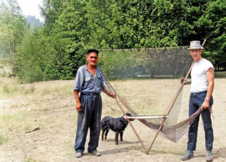
Besides being the keeper of the Mawenok language, Harvey also maintained another part of local Indian culture. He made finely crafted dip nets that were used at ocean locations such as Moonstone Beach to gather surf fish.
Harvey Maple shows one of his dipnets to Dennis Turner. Photo: Gloria Turner. Colorized by the author.
###
You like Humboldt history? In addition to buying Jerry Rohde’s new book to read the rest of his stories about the Mawenoks and other local peoples, consider becoming a member of the Humboldt County Historical society. The Humboldt County Historical Society is a nonprofit organization devoted to archiving, preserving and sharing Humboldt County’s rich history. You can become a member and receive a year’s worth of new issues of The Humboldt Historian at this link.


CLICK TO MANAGE