A digital rendering of a back country trail through Eel River Canyon. | All images sources from the Great Redwood Trail Master Plan unless otherwise stated.
###
The roadmap is set. After four years of planning and public outreach, the Great Redwood Trail Agency (GRTA) has approved a master plan to guide the development of a 300-mile hiking, biking and equestrian trail along the abandoned railway between Humboldt Bay and San Francisco Bay. Once complete, the Great Redwood Trail is projected to be the longest rail-to-trail project in the nation.

Map of the envisioned path of the Great Redwood Trail. Click to enlarge.
The 738-page master plan — linked here — lays out a comprehensive framework for designing, constructing and managing the northern segment of the planned route, which follows the tracks of the defunct Northwestern Pacific Railroad through scenic stretches of rural Humboldt, Mendocino and Trinity counties. (The southern portion of the trail is overseen by the Sonoma-Marin Area Rail Transit and isn’t covered in the GRTA’s master plan.)
The wide-ranging document sets standards and priorities for community engagement and government-to-government partnerships with North Coast tribes. The plan also looks at each section of the railway, outlining various “opportunities” for recreation as well as potential “constraints” that could interfere with the trail’s build-out over the coming decades.
State Senator Mike McGuire, a driving force behind the monumental trail project, touted the approval of the master plan as a “major milestone,” but the real work has only just begun.
“This is a very momentous time, but it is also the beginning of a lot of work to come,” GRTA Operations Manager Bridget Nichols told the Outpost in a recent phone interview. “This document is really a celebration of hundreds and hundreds of hours of so many different people coming together to help us guide this process and move forward with a lot of care and intention. … It outlines where we’re going to go and gives us guidance on how to best incorporate tribes, community members, ecosystems and recommendations from government agencies and local municipalities.”
Segment by Segment: Complexities and Opportunities Along the Great Redwood Trail
While some stretches of the Great Redwood Trail won’t see construction for at least another decade, several sections have already been built, are currently under construction or are deep in the project design phase. Of the 300-plus miles of envisioned trail, 47 miles are already open to the public, including nearly 12 miles along Humboldt Bay.
The master plan doesn’t set specific timelines for the completion of each stretch of trail, but it does rank the feasibility, impact and project readiness of the 43 segments on a scale of one to three stars. (Check out this table for a segment by segment breakdown.)

An abandoned train car near Dos Rios.
“The [segments] with more stars tend to be tier one,” Nichols said. For example, the Alderpoint section, a five-mile stretch between Cain Rock Railroad Bridge and Steelhead Creek, is ranked “tier one” because the rail line will be easier to convert than, say, the southern portion of Eel River Canyon, which is riddled with collapsed bridges and decaying train cars. “The Alderpoint segment is very feasible, infrastructure-wise, and we have community groups that are ready for it.”
The GRTA is working with Revitalizing Opportunities for the Alderpoint Region (ROAR) to help plan the riverside trail segment and set up jobs for local folks once construction begins.
“They want a better community for their children and for their families to live in, so we’re looking at ways to plan this trail segment that brings life and vitality back to Alderpoint,” Nichols said. “Building the trails would give local contractors an opportunity to work in their own backyard. … We’re also looking at how they can build jobs around maintaining the trail and the surrounding area to keep [residents] employed and to give them something of value that they want to participate in.”
“A lot of times, when we develop one segment of the trail — like the connection between Arcata and Eureka — that the community really wants, we’ll have more help and drive to make it happen,” she added. “We anticipate things like that happening as more and more segments get built.”
Other potential opportunities along the Alderpoint stretch include a cycling loop along Carter Creek that would connect to Fort Seward and a 30-acre campground and day-use area on a piece of GRTA-owned property near Steelhead Creek. As far as complexities go, there is a damaged bridge just south of Steelhead Creek that may require retrofitting or reconstruction.

Complexities and opportunities along the five-mile leg through Alderpoint.
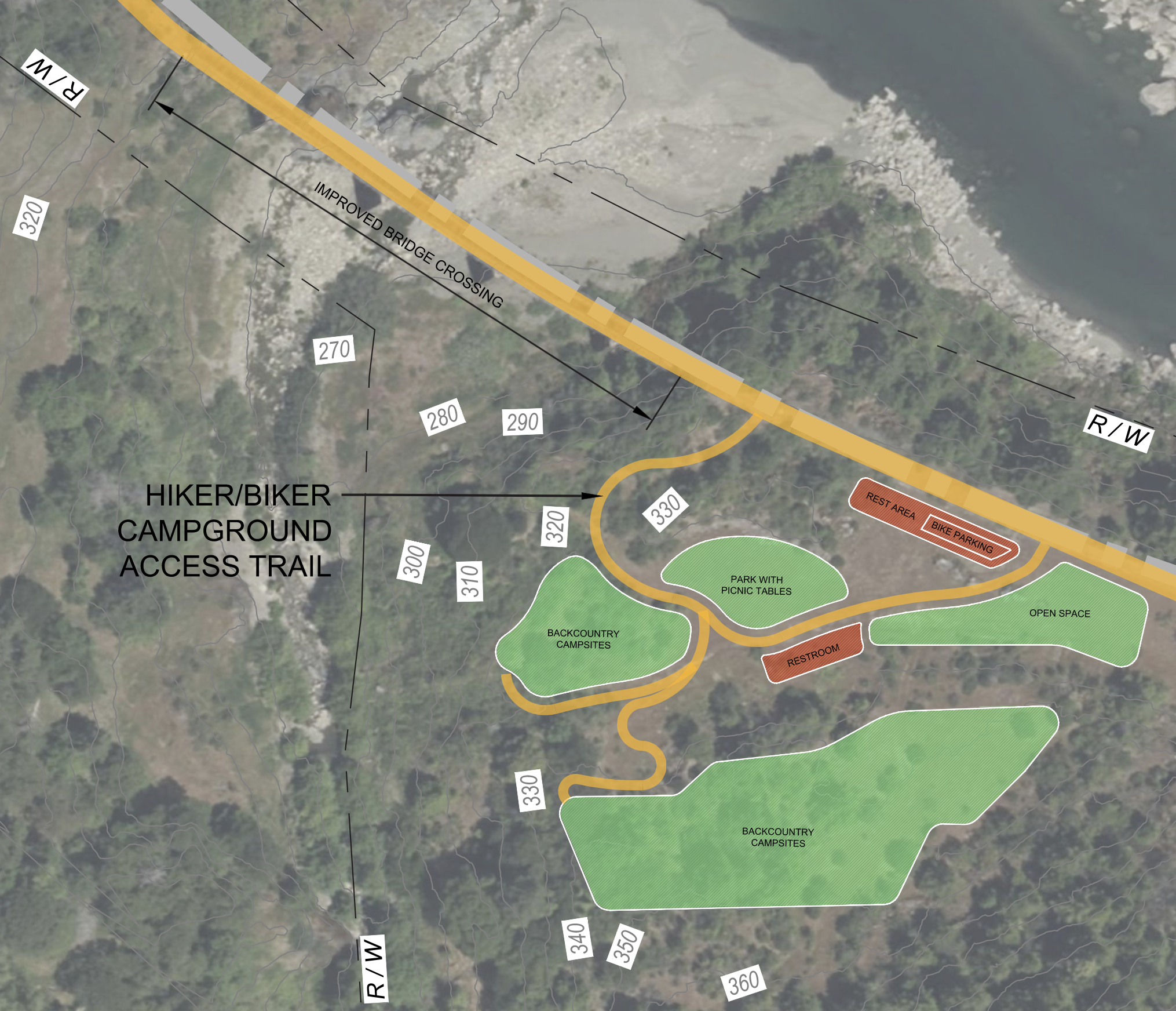
Digital rendering of a potential layout for the Steelhead Creek campsite.
Many of the bridges, trestles and tunnels located elsewhere on the trail may be subject to reconstruction or replacement depending on the severity of the damage. The Loleta tunnel, for example, will require “significant remediation” because it’s structurally compromised.
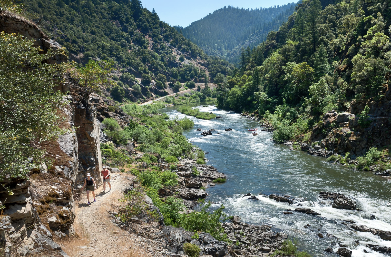
The most complex segments of the trail — including a remote 42.5-mile stretch from Longvale to Island Mountain in Mendocino County and another section between Holmes and Stafford in Southern Humboldt — will have to undergo significant environmental remediation before construction can begin. About a dozen “constraints” are noted along both segments, especially through Eel River Canyon, where numerous landslides have destroyed bridges and collapsed tunnels.
“We’ll have to remove the rail cars that have slid into the Eel River and other railroad-related infrastructure,” Nichols said. “These are large restoration projects, but they’re not unachievable. We have funding that’s dedicated specifically to restoring the Eel, which is a Wild and Scenic river. As a state agency, it’s our responsibility to leave this area in a better place than the railroad did, and we’re really looking at this ultimately as a restoration project.”

A washed out corridor of a suspended track.
It’s a huge undertaking. That stretch through Eel River Canyon is about as rural as it gets, and there aren’t many roads out there. Much of the surrounding area is protected by the Wildlands Conservancy, which acquired the 26,600-acre Eel River Canyon Preserve a few years ago, and most of the rest is owned by old ranching families.
Given the access limitations, Nichols said the GRTA will have to work with adjacent landowners to get the railroad ruins out of the canyon.
“Now that we’ve completed the master plan, we can actually get into the nuts and bolts of how we’re going to do it, possibly through private access roads,” she said. “It’s going to be a huge project and a massive undertaking, that’s why we don’t have those segments of trail slated [for completion] for many years. There’s also a lot of cultural resources we want to address in the area, and work with tribes to make sure we’ve done our part before any of it is open to the public.”

A trestle near Loleta.
Addressing Tribal Concerns
The envisioned path of the Great Redwood Trail passes through the ancestral lands of more than 20 tribal nations. Leading up to the public review process, a group of Wailaki descendants and their allies expressed concern about potential impacts to the Eel River Canyon Preserve and demanded a more prominent role in the decision-making process.
During the development of the draft master plan, the GRTA sought input from 35 tribes across Northern California through in-person meetings with indigenous leaders, webinars and community workshops, and incorporated their feedback into the final document (section 2.2, pages 52-55). Several tribes expressed interest in either ownership or stewardship of segments of the trail that pass through their ancestral lands and asked for their leadership to be included in the design and planning process.
In the first few pages of its executive summary, the master plan underscores the importance of “early and ongoing collaboration with local tribes” to protect culturally significant resources. Still, GRTA Executive Director Elaine Hogan acknowledged that “deep and trusting relationships with Tribal Nations and members take time to build.”
“Therefore, it’s on us to reach out often and in as many ways as we can,” Hogan wrote in an emailed statement. “We’ve heard specific concerns, inspiration and excitement, and everything in between. Every relationship, perspective, and conversation requires individual respect and attention.”
The GRTA Board of Directors is looking to hire a tribal liaison who will help assemble a tribal advisory board that will ensure tribal concerns are top of mind throughout the trail development process, Hogan said.
“While many Native folks engaged early and often, the relationship- and trust-building doesn’t stop once the Master Plan is done,” she continued. “[I]t is most helpful when Tribal leaders are willing to have direct conversations with GRTA staff about their needs and wishes. We’re doing our best now with our lean staff to advance these conversations, and look forward to even more once our Tribal Liaison Consultant is in place. We’re also hoping to formalize more Tribal partnerships as we move forward with design and implementation.”

An existing tunnel along Eel River Canyon.
The board has also passed several actions to increase tribal involvement in the trail project, including a professional services agreement with the Wiyot Tribe for cultural monitoring and memorandums of understanding (a government-to-government partnership) with both the Hopland Band of Pomo Indians and the Blue Lake Rancheria.
In a statement issued following the board’s approval of the master plan, Jason Ramos, Tribal Chairman of the Blue Lake Rancheria, said the Great Redwood Trail provides a “critical opportunity to restore fish habitat, protect cultural resources, and build an economy that benefits the North Coast communities who have always called this place home.”
“The master plan for trail development represents a meaningful step toward ensuring that Tribal communities are not just consulted, but are genuine partners in how this land is stewarded and celebrated,” he continued. “Blue Lake Rancheria is committed to staying at the table every step of the way.”
[DISCLOSURE: The Blue Lake Rancheria is a minority owner of the Outpost’s parent company, Lost Coast Communications, Inc.]

Existing trail in Blue Lake.
Improving Safety and Expanding Emergency Response
Yet another concern that’s been raised throughout the public review process is the issue of safety along the trail — especially on the remote, undeveloped stretches where emergency services are scant and cell service is nonexistent. Property owners along the trail have also expressed concerns about trespassing and other nuisance behavior from trailgoers.
In an interview with the Outpost last year, Humboldt County Sheriff William Honsal said it would be “impossible for [HCSO] to enforce anything along that trail, yet it is going to be our responsibility to do so.”
Nichols, the GRTA spokesperson you heard from earlier in this story, clarified that the agency never expected the sheriff’s office to patrol the trail. “We’ve been in direct communications with Sheriff Honsal and other first responders, and we take his concerns seriously,” she said. “A formalized approach to emergency response and enforcement will be needed, and we’re planning for that now, before segments are open to the public.”

The Eel River near Dos Rios.
Last year, the GRTA board approved contracts with two community-based organizations — The People of New Directions in Humboldt County and Friend of Boon in Mendocino County — to provide property management and supportive services to people experiencing homelessness on the trail. However, those organizations are focused on trails that pass through urban centers that are already open to the public.
“We plan on building out our own field operations and staff to be stationed in the back country who are trained in wilderness first response. We also plan on creating formal agreements with local law enforcement and volunteer fire departments to strengthen the rural emergency response capacity,” Nichols said. “We’re looking at this as an investment in community resilience, not a burden on local agencies.”
The GRTA is using the Lost Coast Trail as a case study to understand how first responding agencies work together to patrol a remote region. The master plan notes that the Bureau of Land Management (BLM) uses an overnight camping permit system that helps staff and emergency responders keep track of who is camping on the trail and where they may be located. When an emergency does occur, the responsibility is shared among the BLM, sheriff’s office and U.S. Coast Guard.
“If the location [of an emergency] is close to a road or access point, the [HCSO] is the first responder,” the master plan states. “If it is easier to access from the water or by helicopter, the U.S. Coast Guard responds first. Humboldt County and the BLM also have an ATV that can be used to respond to incidents on remote portions of this trail.”
This kind of model “really demonstrates how remote trail systems can operate successfully with the right planning partnerships and management structures in place,” Nichols said, noting that private property matters will be handled on a case-by-case basis.
In the meantime, while the GRTA works out next steps for each segment, the agency is asking residents to avoid sections of the defunct rail line that aren’t officially open to the public.
“I know that there’s a lot of enthusiasm and people really want to get out there, but … it’s not all open to the public yet,” Nichols said. “We really want to encourage people not to go on unopened segments of the trail yet because we want to be the agency that follows through with the neighbors, reviews the safety of the infrastructure in that area and works with the tribes to protect the cultural resources.”
###
If you’re still itching to make your thoughts known, the senior civics class at Redwood Montessori is conducting a survey on the Great Redwood Trail — linked here. The findings will be presented to the Humboldt County Board of Supervisors in May.
And if you’d like to take it up a notch and have some decision-making power in the future of the trail, you might want to apply for the opening on the board of directors. More information here.
CLICK TO MANAGE