Today the Outpost is pleased to launch the Internet’s newest feature: Weed or No Weed! This is a treasure hunt, and through it we’re all going to find out more about the current state of the cannabis industry in Humboldt County.
Weed in Humboldt County is hardly new, but the times are. These days, the county’s most vociferous industry group is actively calling for county government to regulate growers. Four states have legalized recreational weed, in one form or another, and everyone expects California to follow suit next year. As weed slowly emerges from the underground, we are finally starting to have grown-up conversations about marijuana cultivation – the size of its contribution to the local economy, its impact on the environment, the type of regulatory regime that should govern it.
Those grown-up conversations are getting underway, but they are hobbled by a paucity of information. Growers are coming out from underground, but they aren’t all the way there yet. How many marijuana farms are there in Humboldt County? No one knows. How can elected officials, or the public, or even the industry itself plan for the future when it has no clue what the present looks like?
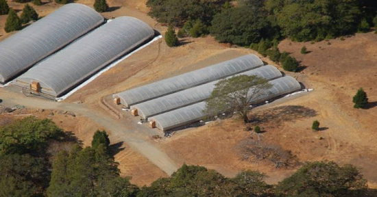
That’s where Weed or No Weed comes in. Gone are the days when growers carefully hid their crops underneath strategically pruned manzanita bushes, hoping to evade the notice of helicopters. Today’s grows are easily visible from outer space. With enough time – or enough people – we could easily count them all.
See “Five Giant Greenhouses Containing 3,500 Marijuana Plants Discovered on Salmon Creek Road,” Sept. 16, 2014
And that’s what we’re going to do.
Playing Weed or No Weed is its own reward. Everyone loves a treasure hunt. More than that, though, the Outpost hopes to use what we find to see what it tells us about a major sector of the Humboldt County economy, one that the public has surprisingly little hard information on. How many grows are there in the Humboldt County backwoods? Where are they, regionally? Can we count them by watershed? What percentage of them are on land zoned for agriculture, or timber production, or residential housing? How many are on parcels under five acres in size? How many on parcels over five acres? How many are untaxed? These are just some of the questions we’re looking to answer with this.
There are around 72,000 individual parcels of land in Humboldt County. This first iteration of Weed or No Weed looks at precisely 28,851 of those parcels – those that are larger than one acre. We’re going to check those parcels and see if they have weed – or if they have no weed.
So, yeah, we’re probably not going to find all the weed in Humboldt County. Some percentage of the industry still takes place in urban grow houses, and some percentage happens on parcels less than acre in size. But it’s a pretty good start.
When all is said and done – after we’ve all gone over all 28,851 parcels in the system several times, having clicked our Weed button or our No Weed button, as the case may be – we’ll start sorting out what it is we have found. The first question we’ll ask of the data is how reliable it is. After that, we’ll start asking the kind of systemic questions mentioned above, in the hope that the public might be better informed as we transition toward regulation and decriminalization.
CRITICAL NOTE: Weed or No Weed is not attempting to identify individual growers. In fact, we’ve put in a good deal of effort, here, to make this a completely non-useful tool for that sort of thing – far less useful than just browsing around on Google Maps. Here are two ways we’ve done that.
- No individual parcel is linkable in the Weed or No Weed world. You can’t find some hella huge grow and send it to all your Facebook friends. Weed or No Weed gives you a random parcel every time, and that’s all you get.
- When you look at a parcel on Weed or No Weed, the parcel is all you see. Everything surrounding a piece of property is painted over with electronic White-Out. You can’t zoom out to see your surroundings. You can’t pan around to find nearby landmarks. You get to see the land in question, and basically that is all you see. You won’t be able to determine where you are, precisely, unless you happen to be already familiar with the land in question.
To repeat: You get far less information with Weed or No Weed than you would browsing around Google Earth or whatever.
OK! Let’s get going! Click over to Weed or No Weed right now. Zoom in. Pan around. Determine if there is weed – or if there is no weed. If you have found weed, click the green “Found the Weed!” button. If you find no weed, click the red “No Weed Here” button. If you’re not sure, click the gray button that indicates your uncertainty. Repeat as necessary. If you need more help with this, a tutorial is available. But it is pretty self-explanatory, especially to longtime Humboldters.


CLICK TO MANAGE