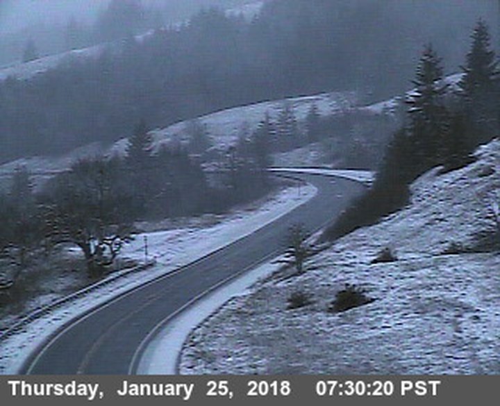
Berry Summit at 7:30 a.m. Photo: Caltrans.
Did a nice little flurry of hail pelt down on y’all’s homes and yards this morning? It blew through Eureka at about 6:30 a.m., and dropped enough to stick to the deck at LoCO HQ.
There’s snow up in the mountains. Caltrans briefly imposed chain controls on Highway 299 at Berry Summit this morning, but those have been lifted now. Might be a short respite, though, because more winter weather is on the way.
The current forecast calls forecast calls for snow levels to drop to between 2,000 and 2,500 feet today and tomorrow. Then another storm hits Saturday, before the rain starts to taper off for a while on Sunday.
The National Weather Service office on Woodley Island alerts us, via its Facebook page, that rain and thunderstorms are possible along the coast north of Cape Mendocino today.
Full forecast discussion from the National Weather Service below:
SYNOPSIS
Showery weather will continue into Friday before the next storm system arrives on Saturday. Drier weather should return on Sunday and may persist through next week.
DISCUSSION
An upper level trough will bring additional precipitation to northwest California today, which is already being observed this morning. Isolated thunderstorms are currently ongoing across the across ocean and along the immediate coast while rain and snow showers are occurring inland. Snow levels will continue to fall throughout the day and bottom out around 2,000 to 2,500 feet thus the Winter Weather Advisory remains for interior Del Norte, Humboldt, and Trinity counties through Friday morning. Precipitation will then briefly taper off on Friday before the next storm system arrives for Saturday. There is still some question about the timing, placement and strength of this system but it does appear likely that areas north of Cape Mendocino will see rain, with chances diminishing as you move south. Models are suggesting that we will see a stretch of drier weather starting Sunday, with Del Norte County possibly seeing some light mid week rain. .
AVIATION
Generally wet weather will persist throughout the day as multiple upper level shortwaves prolong shower activity across northwest California. Thunderstorms will be possible near coastal areas primarily through the mid to late morning hours. VFR conditions will be possible across much of the region, however, heavier showers will bring MVFR and possibly IFR throughout the day.
KML && .MARINE
Moderate and generally southwest/west winds will persist through Friday before a frontal boundary brings the next round of increasing south winds for late Friday night. Steep waves will gradually subside today, however, an incoming swell system will bring quite large seas. Expect 15 to 17 foot seas to develop by this afternoon. Seas will subside on Friday but remain near 10 to 12 feet into the early half of the weekend. Small craft advisories remain in effect through the weekend primarily for larger seas.
EKA WATCHES/WARNINGS/ADVISORIES
Winter Weather Advisory until 4 AM PST Friday for CAZ102-105>108- 111. NORTHWEST CALIFORNIA
COASTAL WATERS
Small Craft Advisory until 9 PM PST Saturday for PZZ455-475. Small Craft Advisory until 3 AM PST Sunday for PZZ450-470.
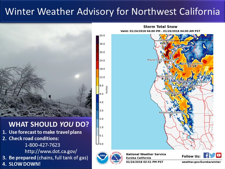
Graphic: National Weather Service, Eureka.
CLICK TO MANAGE