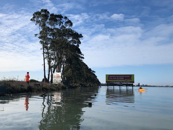
King tide on Humboldt Bay, Dec. 14, 2020 | Photo: Ryan Burns
The surf will be particularly high and dangerous over the next few days, leading up to king tides — extremely high tides that occur only a couple of times a year — on Monday Jan. 11 and Tuesday Jan. 12.
King tide events can provide an idea of what “normal” tide levels might look like in the future and help with planning for sea level rise. The City of Arcata is asking you to send in your king tide photos and the California Coastal Commission is also looking for pics to use for its King Tide Project. You can find a map of suggested places to view the king tide here.
Wherever you decide to view or document the water, make sure you do it safely! When large ocean swells coincide with high tides, the combination brings an increased change of damage and flooding. The U.S. National Weather Service and the Bureau of Land Management remind you to avoid climbing on coastal rocks and jetties over the next few days and to never turn your back on the ocean.
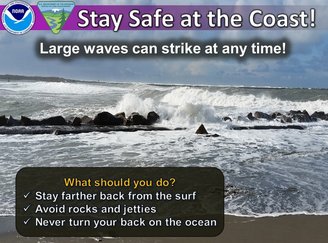
“Jetties are particularly dangerous and large waves can appear suddenly,” the National Weather Service Eureka posts on its Facebook page. “Don’t be fooled by rocks and jetties that seem to be too high to be overtopped by waves. It might just be a period of smaller waves. Larger waves can suddenly appear and wash over previously dry rocks and jetties.”
You can find more information about the king tides and how to send in your photos in this press release from the City of Arcata:
The City of Arcata is seeking community assistance with photo-documenting water levels on Arcata Bay and in local creeks and streams during the King Tide events occurring Monday, January 11 and Tuesday, January 12.
King Tide events show projections of what “normal” tide levels could look like in the future as a result of sea level rise, and a visual record of King Tide events from year to year provides valuable data used by City staff when planning for sea level rise.
On Monday, January 11 at 10:18 a.m. and Tuesday, January 12 at 11:08 a.m., all community members are invited to observe and photograph the highest tides at key locations of interest throughout Arcata. A “King Tide Guide ” map of the observation sites can be found at cityofarcata.org.
Photographs of the tides can be emailed to kingtide@cityofarcata.org to be added to the City’s King Tide GIS Storymap in the future. Images may also be shared with the California Coastal Commission’s statewide King Tide Project at coastal.ca.gov/kingtides. Photographs of the tides at locations in Humboldt County not included in the “King Tide Guide” are also welcome and encouraged.
In addition, on Tuesday, January 12, the City will host a virtual King Tide and Sea Level Rise Discussion at 2 p.m. The conversation will include information on how King Tide events can show effects of future sea level rise, photos of past King Tide events will be shared and Community Development Director, David Loya, will discuss how the City is approaching responses to sea level rise. A Zoom link to attend can be found at cityofarcata.org.
All community members who choose to observe the King Tides are urged to follow safety precautions around water and COVID-19, and more detailed information on how to safely observe the tides can be found at cityofarcata.org. For more information about KingTides and sea level rise, contact the Community Development Department at kingtide@cityofarcata.org.
CLICK TO MANAGE